Information and Reports Specialist
Office of the Associate Director for Ecosystems
Email:
shouse@usgs.gov
Office Phone:
619-225-6133
Fax:
619-225-6101
ORCID:
0000-0002-3398-4742
Location
San Diego State University
4165 Spruance Road
Suite 200
San Diego
, CA
92101
US
Supervisor:
Linda A Weir
|

In this project, we assessed the potential for twelve coastal wetland sites on the island of Molokaʻi, Hawaiʻi, to provide socio-cultural resources and habitat for flora and fauna following restoration. In April 2022, a rapid field assessment of hydrology, soils, and vegetation was carried out at each of the wetland sites. In this data release, all the vegetation data collected during the rapid field assessment are provided. The vegetation datasets consist of three spreadsheets found in the "Attached Files" section. Each dataset has its own description.
|
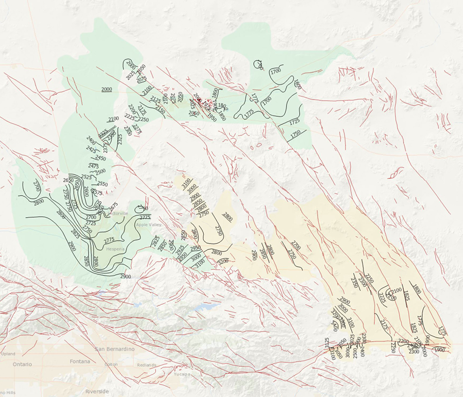
During 2014, the U.S. Geological Survey and other agencies made approximately 1,026 water-level measurements in the Mojave River and Morongo groundwater basins. These data document recent conditions and, when compared with previous data, changes in groundwater levels. A water-level contour map was drawn using data from about 610 wells, providing coverage for most of the basins. Twenty-four hydrographs show long-term (1930-2014) water-level conditions throughout the basins, and 9 short-term (1992 to 2014) hydrographs show the effects of recharge and discharge along the Mojave River. In addition, a water-level-change map was compiled to compare was compiled to compare the 2014 water levels to the 2012 water levels...
Categories: Data Release - Revised;
Tags: USGS,
USGS Science Data Catalog (SDC),
contours,
drainage basin,
ground water, All tags...
ground-water,
groundwater,
hydrology,
inland waters,
inlandWaters,
levels,
water level,
water table, Fewer tags
|

In this project, we assessed the potential for twelve coastal wetland sites on the island of Molokaʻi, Hawaiʻi, to provide socio-cultural resources and habitat for flora and fauna following restoration. In April 2022, a rapid field assessment of hydrology, soils, and vegetation was carried out at each of the wetland sites. The data provided here were collected in order to inform a prioritization protocol for ranking wetlands on Molokaʻi for restoration. Soil samples were collected at each of the sites at three different depth ranges (0-2, 24-26, and 48-50 cm). Samples from 0-2 cm and 24-26 cm were analyzed for % organic carbon and soil texture. These two measures provide a basic understanding of the status of coastal...
Tags: Ecology,
Molokai,
Soil Sciences,
USGS Science Data Catalog (SDC),
biota, All tags...
groundwater,
hydrology,
natural resource management,
soil chemistry,
vegetation,
wetlands, Fewer tags
|
Hawaiian coastal wetlands provide important habitat for federally endangered waterbirds and socio-cultural resources for Native Hawaiians. Currently, Hawaiian coastal wetlands are degraded by development, sedimentation, and invasive species and, thus, require restoration. Little is known about their original structure and function due to the large-scale alteration of the lowland landscape since European contact. Here, we used 1) rapid field assessments of hydrology, vegetation, soils, and birds, 2) a comprehensive analysis of endangered bird habitat value, 3) site spatial characteristics, 4) sea-level rise projections for 2050 and 2100 and wetland migration potential, and 5) preferences of the Native Hawaiian community...
|

In this project, we assessed the potential for twelve coastal wetland sites on the island of Molokaʻi, Hawaiʻi, to provide socio-cultural resources and habitat for flora and fauna following restoration. In April 2022, a rapid field assessment of hydrology, soils, and vegetation was carried out at each of the wetland sites. In this dataset, all the hydrologic data collected during the rapid field assessment are provided.
|
View more...
|