|
|

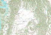
For a description of each map layer, select the Details tab, then select a Layer Name. This GIS dataset is part of a suite of wildlife habitat connectivity data produced by the Washington Wildlife Habitat Connectivity Working Group (WHCWG). The WHCWG is a voluntary public-private partnership between state and federal agencies, universities, tribes, and non-governmental organizations. The WHCWG is co-led by the Washington Department of Fish and Wildlife (WDFW) and the Washington Department of Transportation (WSDOT). This dataset quantifies current wildlife habitat connectivity patterns for the Columbia Plateau Ecoregion in Washington, Oregon, and Idaho. Available WHCWG raster data include model base layers, resistance,...
Tags: columbia plateau ecoregion,
core area,
cost-weighted distance,
idaho,
landscape integrity, All tags...
normalized least-cost corridor,
oregon,
pacific northwest,
usa,
washington, Fewer tags
|

For a description of each map layer, select the Details tab, then select a Layer Name. This GIS dataset is part of a suite of wildlife habitat connectivity data produced by the Washington Wildlife Habitat Connectivity Working Group (WHCWG). The WHCWG is a voluntary public-private partnership between state and federal agencies, universities, tribes, and non-governmental organizations. The WHCWG is co-led by the Washington Department of Fish and Wildlife (WDFW) and the Washington Department of Transportation (WSDOT). This dataset quantifies current wildlife habitat connectivity patterns for the Columbia Plateau Ecoregion in Washington, Oregon, and Idaho. Available WHCWG raster data include model base layers, resistance,...
Tags: columbia plateau ecoregion,
core area,
cost-weighted distance,
focal species,
habitat concentration area, All tags...
idaho,
least-cost corridor,
least-cost path,
oregon,
pacific northwest,
resistance,
stick map,
usa,
washington,
wildlife habitat connectivity, Fewer tags
|

For a description of each map layer, select the Details tab, then select a Layer Name.
|

For a description of each map layer, select the Details tab, then select a Layer Name.
|
View more...
|