|
|

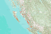
Priority Conservation Areas for the Willamette Valley - Puget Trough - Georgia Basin Ecoregion. October, 2003. The Willamette Valley-Puget Trough-Georgia Basin ecoregion is a long ribbon of broad valley lowlands and inland sea flanked by the rugged Cascade and coastal mountain ranges of British Columbia, Washington, and Oregon. It encompasses some 5,550,000 ha of Pacific inlet, coastal lowlands, islands, and intermontane lowland, and extends from the Sunshine Coast and eastern lowland of Vancouver Island along Georgia Strait, south through Puget Sound and the extensive plains and river floodplains in the Willamette Valley. Five expert technical teams collaborated on a series of analyses based on methods developed...
|

Conservation Area Name = portfolio sites selected by automation (the SITES algorithm) and expert input The Canadian Rocky Mountains ecoregion (CRM) covers approximately 27.1 million hectares (66.9 million acres) extending across three states and two provinces. The ecoregion extends over a large portion of the Rocky Mountains from southeastern British Columbia and southwestern Alberta to northern Idaho, northwestern Montana and a small part of northeastern Washington. Elevation ranges from 915 m to 3,954 m (3,000 ft to 12,972 ft), with Mt. Robson (BC) being the highest peak in the ecoregion. Geologically, this ecoregion is very complex, containing bedrock of sedimentary, igneous, and metamorphic origin; and is largely...
|

Ecoregional assessments provide a regional scale, biodiversity-based context for implementing conservation efforts. The intent of the assessments is to create a share division for agencies and other organizations at the regional, state and local levels to form partnerships and ensure efficient allocation of conservation resources. The assessments identify a portfolio of sites for conservation action with a goal of protecting representative biodiversity and ecologically significant populations. These assessments are the result of rigorous analysis, incorporating expert review, and are the most comprehensive and current efforts that support spatially explicit priority setting at an ecoregional scale. Biodiversity...
|

Ecoregional assessments provide a regional scale, biodiversity-based context forimplementing conservation efforts. The intent of the assessments is to create a sharedvision for agencies and other organizations at the regional, state and local levels to formpartnerships and ensure efficient allocation of conservation resources. The assessments identify a portfolio of sites for conservation action with a goal of protecting representativebiodiversity and ecologically significant populations. These assessments are the result ofrigorous analysis, incorporating expert review, and are the most comprehensive and currentefforts that support spatially explicit priority setting at an ecoregional scale. Biodiversityconservation...
|
This work represents a joint effort between Round River Conservation Studies (RRCS), The Nature Conservancy of Canada (NCC), The Nature Conservancy – Alaska (TNC), with assistance from the Coastal Information Team (CIT) Ecosystem Spatial Analysis Planning Team. This effort included a diverse group of researchers from non-governmental and government agencies and represents a collective of researchers and practitioners in the fields of conservation biology, ecology, zoology, Geographical Information Systems (GIS), and land-use planning. To assist the Central Coast Land and Resource Management Planning (Central Coast LRMP) in its decision-making, the Ecosystem Spatial Analysis team was asked to explore a number of...
|
View more...
|