|
|
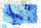
This dataset represents the average annual amount of water contributed to the stream network for each watershed, simulated by the model MC1 for the 30-year period 1971-2000. Simulated mean streamflow (stormflow + baseflow + runoff) was determined for each HUC5 watershed. Watersheds represent 5th level (HUC5, 10-digit) hydrologic unit boundaries and were acquired from the Natural Resources Conservation Service. Streamflow units are comparable to rainfall - millimeters of water per year. Background: The dynamic global vegetation model MC1 (see Bachelet et al. 2001) was used to simulate vegetation dynamics, associated carbon and nitrogen cycle, water budget, and wild fire impacts for OR, WA, AZ and NM, for a project...
Tags: arizona,
climate change,
dynamic global vegetation model,
huc5,
hydrologic units, All tags...
mc1,
new mexico,
simulation,
streamflow,
watersheds, Fewer tags
|

Change in the majority generalized vegetation type for each HUC5 watershed between historical (1971-2000) and future (2071-2100) time periods. The MC1 dynamic vegetation model was run under the CSIRO, MIROC, and Hadley climate change projections and the A2 anthropogenic emissions scenario. Majority generalized vegetation type was determined for each HUC5 watershed from from original ~ 4 km raster data. Generalized vegetation types were assigned by combining detailed MC1 vegetation classes into four general catagories: desert, grassland, shrubland, and forest. Watersheds represent 5th level (HUC5, 10-digit) hydrologic unit boundaries and were acquired from the Natural Resources Conservation Service. Background:...
Tags: climate change,
dynamic global vegetation model,
future vegetation type,
huc5,
hydrologic units, All tags...
mc1,
model,
oregon,
simulation,
washington,
watersheds, Fewer tags
|

Change in the majority generalized vegetation type for each HUC5 watershed between historical (1971-2000) and future (2071-2100) time periods. The MC1 dynamic vegetation model was run under the CSIRO, MIROC, and Hadley climate change projections and the A2 anthropogenic emissions scenario.Majority generalized vegetation type was determined for each HUC5 watershed from from original ~ 4 km raster data. Generalized vegetation types were assigned by combining detailed MC1 vegetation classes into four general catagories: desert, grassland, shrubland, and forest. Watersheds represent 5th level (HUC5, 10-digit) hydrologic unit boundaries and were acquired from the Natural Resources Conservation Service. Background:...
Tags: arizona,
climate change,
dynamic global vegetation model,
future vegetation type,
huc5, All tags...
hydrologic units,
mc1,
model,
new mexico,
simulation,
watersheds, Fewer tags
|

Percent change in the average C3 grass fraction (a biogeographic index based on the ratio of C3 to C4 grass) for each HUC5 watershed between historical (1971-2000) and future (2071-2100) time periods. The MC1 dynamic vegetation model was run under the CSIRO, MIROC, and Hadley climate change projections and the A2 anthropogenic emissions scenario.Simulated mean C3 grass fraction was determined for each HUC5 watershed. Watersheds represent 5th level (HUC5, 10-digit) hydrologic unit boundaries and were acquired from the Natural Resources Conservation Service. Background: The dynamic global vegetation model MC1 (see Bachelet et al. 2001) was used to simulate vegetation dynamics, associated carbon and nitrogen cycle,...
Tags: c3 to c4 grasses,
climate change,
dynamic global vegetation model,
grass fraction,
huc5, All tags...
hydrologic units,
mc1,
model,
oregon,
simulation,
washington,
watersheds, Fewer tags
|

This dataset represents the average amount of live tree carbon for each HUC5 watershed, simulated by the model MC1 for the 30-year period 1971-2000. Simulated mean live forest carbon (output variable C_Forestyr in MC1 version B60, which includes both above and below-ground tree carbon) was determined for each HUC5 watershed. Units are grams per square meter. Watersheds represent 5th level (HUC5, 10-digit) hydrologic unit boundaries and were acquired from the Natural Resources Conservation Service. Background: The dynamic global vegetation model MC1 (see Bachelet et al. 2001) was used to simulate vegetation dynamics, associated carbon and nitrogen cycle, water budget, and wild fire impacts for OR, WA, AZ and...
Tags: climate change,
dynamic global vegetation model,
huc5,
hydrologic units,
live forest carbon, All tags...
mc1,
model,
oregon,
simulation,
washington,
watersheds, Fewer tags
|
View more...
|