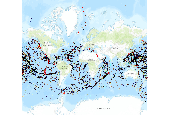
Seamounts and vents map citation: Kitchingman and Lai 2004, Ramirez-Llodra and Baker 2006. Map data source: Kitchingman, A. and S. Lai. 2004. âInferences on potential seamount locations from mid-resolution bathymetric data.â In: Morato T, Pauly D (eds) Seamounts: Biodiversity and Fisheries. Fisheries Centre, University of British Colombia, Vancouver, Canada, pp 7-12 Ramirez-Llodra, E. and M.C. Baker. 2006. Data on the location of hydrothermal vents. Biogeography of Chemosynthetic Ecosystems (ChEss) Project (www.noc.soton.ac.uk/chess). Map Technical Notes Locations of seamounts are from (Kitchingman and Lai 2004) and were developed from a global GIS based analysis, which identifies a total of 14,000 seamounts. There is no strict [...]
Summary
Seamounts and vents map citation: Kitchingman and Lai 2004, Ramirez-Llodra and Baker 2006. Map data source: Kitchingman, A. and S. Lai. 2004. âInferences on potential seamount locations from mid-resolution bathymetric data.â In: Morato T, Pauly D (eds) Seamounts: Biodiversity and Fisheries. Fisheries Centre, University of British Colombia, Vancouver, Canada, pp 7-12 Ramirez-Llodra, E. and M.C. Baker. 2006. Data on the location of hydrothermal vents. Biogeography of Chemosynthetic Ecosystems (ChEss) Project (www.noc.soton.ac.uk/chess). Map Technical Notes Locations of seamounts are from (Kitchingman and Lai 2004) and were developed from a global GIS based analysis, which identifies a total of 14,000 seamounts. There is no strict definition of what constitutes a seamount, but this dataset is conservative and excludes longer ridge-type formations or lower features. Some authors have suggested there may be a total of 50,000 or more. Locations of hydrothermal vents were generously provided by Eva Ramirez-Llodra and Maria C. Baker of the Biogeography of Chemosynthetic Ecosystems (ChEss) Project. The locations of many of these communities closely follow tectonic plate boundaries of spreading mid-ocean ridges and back-arc basins. The point on the map represent only known locations â thousands more such communities are yet to be discovered.
