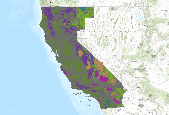
The LND_SurfaceEstate data is a geodatabase illustrating the location of Federal and State managed lands in California and portions northwest Nevada. The data is developed and maintained at the BLM California State Office in Sacramento. The focus of the data development efforts are on accurately depicting the locations of BLM managed lands. Private and non-governmental lands are categorized as unclassified. Other Federal agencies, the State of California , and numerous County governments contribute much of the information and data incorporated into this geodatabase.
Summary
The LND_SurfaceEstate data is a geodatabase illustrating the location of Federal and State managed lands in California and portions northwest Nevada. The data is developed and maintained at the BLM California State Office in Sacramento. The focus of the data development efforts are on accurately depicting the locations of BLM managed lands. Private and non-governmental lands are categorized as unclassified. Other Federal agencies, the State of California , and numerous County governments contribute much of the information and data incorporated into this geodatabase.
