Skip to main content
Toggle navigation
ScienceBase-Catalog
Communities
Help
About ScienceBase
ScienceBase Help
ScienceBase FAQs
Report a Problem
Developer Reference
Log in
Your browser does not have support for cookies enabled. Some features of this application will not work.
processing ...
ScienceBase Catalog
Data Basin
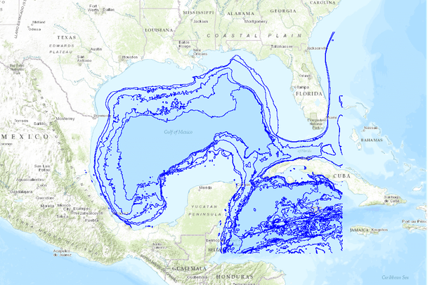
Bathymetric Contours - Gulf of Mexico (General)
View
Item View
Folder View
JSON
Bathymetric Contours - Gulf of Mexico (General)
Dates
Original Data Basin Creation Date
2013-03-15 12:05:16
Original Data Basin Modified Date
2013-03-15 12:05:16
Summary
Bathymetric contours based on digital elevation model of the Gulf of Mexico
Summary
Bathymetric contours based on digital elevation model of the Gulf of Mexico
Contacts
Data Owner :
SouthAtlantic LCC
Attached Files
sorting
Metadata First
Recent First
Alphabetical
Related External Resources
Type: Web Link
Original Item Location
http://databasin.org/datasets/e4021bad4cb6419f998395933d779c81
Owner Profile Page
http://databasin.org/people/SouthAtlanticLCC
Type: Thumbnail Preview Image
Thumbnail Preview Image
http://databasin2-filestore.s3.amazonaws.com/e4021bad4cb6419f998395933d779c81/images/thumbnail.png?v=1363370716
Type: Browse Image
Browse Image
http://databasin2-filestore.s3.amazonaws.com/e4021bad4cb6419f998395933d779c81/images/preview.png?v=1363370716
Preview Image
Map
Communities
Data Basin
Tags
Other
bathymetry
contours
seafloor topography
water depth
Provenance
Data source
DOC/NOAA/NESDIS/NGDC > National Geophysical Data Center, NESDIS, NOAA, U.S. Department of Commerce
Harvested on Fri May 23 09:36:24 MDT 2014 from Data Basin Service
Additional Information
Identifiers
Type
Scheme
Key
UniqueKey
Data Basin
e4021bad4cb6419f998395933d779c81
Item Actions
View Item as ...
JSON
ATOM
ISO XML
Save Item as ...
JSON
FGDC
MODS XML
ISO XML
View Item...
Metrics