US Forest Service Administrative Ranger District Boundaries
Dates
Original Data Basin Creation Date
2013-02-26 13:56:30
Original Data Basin Modified Date
2014-02-11 08:30:49
Summary
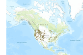
A map service on the www depicting the boundary that encompasses a Ranger District. This map service provides display, identification, and analysis tools for determining current boundary information for Forest Service managers, GIS Specialists, and others. Best available source with a target scale of 1:24000 for Continental U.S., Puerto Rico, and Hawaii and 1:63360 for Alaska.
Summary
A map service on the www depicting the boundary that encompasses a Ranger District. This map service provides display, identification, and analysis tools for determining current boundary information for Forest Service managers, GIS Specialists, and others. Best available source with a target scale of 1:24000 for Continental U.S., Puerto Rico, and Hawaii and 1:63360 for Alaska.
