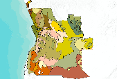
Project abstract: The objective of the National Botanical Institute's (NBI) vegetation mapping project was to map woody plant species to provide estimates of the fraction of individual species contributing to the peak leaf area index for designated vegetation types in southern Africa. The target was to account for 80% of the woody vegetation leaf area in terms of named species, for 80% of the surface area of Africa south of the equator.
The data sources are both published and unpublished species lists for vegetation types and individual sample plots, with the species contribution estimated by local experts in terms of dominants and subdominants. Source maps include: Low and Rebelo (1998) covering South Africa, Lesotho, and Swaziland; Giess (1971) covering Namibia; Wild and Barbosa (1968) covering Botswana, Zimbabwe, Zambia, Malawi, and Mozambique; Barbosa (1970) covering Angola; White (1983) covering Tanzania, Kenya, Uganda, and Somalia; and White (1983) covering Ruanda, Burundi, Congo, and Gabon. Each source map delineates of a wide variety of land cover categories that differ from region to region.
Because vegetation discontinuities exist along some of the regional borders and a perfectly continuous regional map could not be achieved within the timeframe and budget of the project, the final regional map is made up of six independent sub-regional maps. The data set also includes a cross-referenced database of woody plant species, in order of species dominance, associated with all mapped units.
The following areas and vegetation types were excluded according to the sub-project objectives, appearing as transparent in the map : areas north of the Equator, evergreen moist forests, pure grasslands, desert and arid regions, Fynbos. These areas are indicated as such on the final product map. Main water bodies are also mapped specifically.
Note: the database (in CSV format) of woody plant species is attached to this dataset under the "attachments" tab.
