MuleDeerLimitedUseArea is an ESRI SDE Feature Class showing an area within the overall range of mule deer that is only occasionally inhabited and/or contains only a small population of scattered mule deer. This information was derived from field personnel. A variety of data capture techniques were used including drawing on mylar overlays at 1:50,000 scale USGS county mapsheets and implementation of the SmartBoard Interactive Whiteboard using stand-up, real-time digitizing at various scales (Cowardin, M., M. Flenner. March 2003. Maximizing Mapping Resources. GeoWorld 16(3):32-35). Dataset was acquired from a third party distributor who obtained it from CDOW in January 2011. The authoritative data source is available on ArcGIS.com [...]
Summary
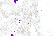
MuleDeerLimitedUseArea is an ESRI SDE Feature Class showing an area within the overall range of mule deer that is only occasionally inhabited and/or contains only a small population of scattered mule deer.
This information was derived from field personnel. A variety of data capture techniques were used including drawing on mylar overlays at 1:50,000 scale USGS county mapsheets and implementation of the SmartBoard Interactive Whiteboard using stand-up, real-time digitizing at various scales (Cowardin, M., M. Flenner. March 2003. Maximizing Mapping Resources. GeoWorld 16(3):32-35).
Dataset was acquired from a third party distributor who obtained it from CDOW in January 2011. The authoritative data source is available on ArcGIS.com (http://www.arcgis.com/home/item.html?id=e10b0db0167a4dde909357b5c13354f1) and will be updated from that location.
