Canada Land Inventory - Land Capability for Forestry, Newfoundland
Dates
Original Data Basin Creation Date
2010-07-09 10:40:17
Original Data Basin Modified Date
2010-07-09 10:46:24
Summary
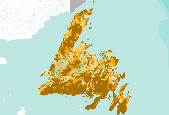
The mapping of land capability for forestry is based on a national classification system comparable with the other Canada Land Inventory sectors. Land is rated according to seven classes on its capability to grow commercial timber in areas stocked with the optimum number and species of trees. This rating considers the land in its natural state, without improvements such as fertilization, drainage, or amelioration practices. This dataset contains Land Capability Ratings for the surveyed portions of the province of Newfoundland. Land ratings and classes may change, however, significant changes will only be achieved through costly and continuing practices. The best lands for tree growth are Class 1 while Class 7 land can not yield timber [...]
Summary
The mapping of land capability for forestry is based on a national classification system comparable with the other Canada Land Inventory sectors. Land is rated according to seven classes on its capability to grow commercial timber in areas stocked with the optimum number and species of trees. This rating considers the land in its natural state, without improvements such as fertilization, drainage, or amelioration practices. This dataset contains Land Capability Ratings for the surveyed portions of the province of Newfoundland.
Land ratings and classes may change, however, significant changes will only be achieved through costly and continuing practices. The best lands for tree growth are Class 1 while Class 7 land can not yield timber in commercial quantities, these represent the extremes. Sub-class attributes explain the specific limitations of the area, using a series of codes. Explanation of these codes is found at: http://geogratis.cgdi.gc.ca/cgi-bin/geogratis/cli/forestry.pl
The capability mappings have a scale of 1:250,000 and are accomplished through interpretation of air photographs and field surveys.
