USGS Alaska IfSAR and DEM Acquisition Plan Objectives for FY15 - FY17 from The National Map 3D Elevation Program (3DEP) - National Geospatial Data Asset (NGDA) National Elevation Data Set (NED)
Dates
Publication Date
2016
Time Period
2015
File Modification Date
2016-09-27 12:18:00
Citation
U.S. Geological Survey, 2016, USGS Alaska IfSAR and DEM Acquisition Plan Objectives for FY15 - FY17 from The National Map 3D Elevation Program (3DEP) - National Geospatial Data Asset (NGDA) National Elevation Data Set (NED): USGS - National Geospatial Technical Operations Center (NGTOC).
Summary
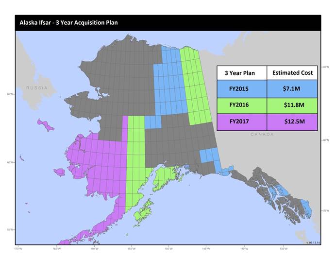
U.S. Geological Survey, Department of the Interior - The annual Alaska IfSAR and DEM acquisition plan is part of the 3DEP initiative to collect high-quality elevation data in the form of interferometric synthetic aperture radar (IfSAR) and light detection and ranging (lidar) data over Alaska. This acquisition plan addresses concerns raised in GAO Report 13-94 regarding geospatial coordination, and supports FGDC data coordination initiatives led by the Department of Interior's Geospatial Information Officer. Mapping a State the size and complexity of Alaska through a partnered effort such as the Alaska Mapping Initiative requires dedicated collaboration and coordination across multiple levels of government. State efforts for the collection [...]
Summary
U.S. Geological Survey, Department of the Interior - The annual Alaska IfSAR and DEM acquisition plan is part of the 3DEP initiative to collect high-quality elevation data in the form of interferometric synthetic aperture radar (IfSAR) and light detection and ranging (lidar) data over Alaska. This acquisition plan addresses concerns raised in GAO Report 13-94 regarding geospatial coordination, and supports FGDC data coordination initiatives led by the Department of Interior's Geospatial Information Officer. Mapping a State the size and complexity of Alaska through a partnered effort such as the Alaska Mapping Initiative requires dedicated collaboration and coordination across multiple levels of government. State efforts for the collection of IfSAR data are being coordinated through Alaska's Statewide Digital Mapping Initiative (SDMI), a cooperative program implemented across six State of Alaska departments and the University of Alaska. Federal efforts are coordinated through the Alaska Mapping Executive Committee (AMEC), chaired by the Department of the Interior with membership from 15 Federal agencies and representatives from the State of Alaska (Charter can be found at http://nationalmap.gov/alaska/amec_charter.html ). The FY17 acquisition plan currently anticipates collecting 16,000 sq. mi. or more depending on partnerships and other contributions to the plan. Interested parties who wish to become a funding partner with the USGS in FY17 or in future years should contact Becci Anderson, USGS Geospatial Liaison, rdanderson@usgs.gov. Products will include: 5M DEM/DSM, Orthorectified IfSAR Intensity Image (ORII), and other standard derived NED datasets. To find out more about the Alaska IfSAR Acquisition for 3DEP initiative go to http://nationalmap.gov/alaska/ami_partners.html