USGS Elevation Availability (NED) Overlay Map Service from The National Map - National Geospatial Data Asset (NGDA) National Elevation Data Set (NED)
Dates
Publication Date
2016
Time Period
2016
File Modification Date
2016-09-26 15:19:00
Citation
U.S. Geological Survey, 2016, USGS Elevation Availability (NED) Overlay Map Service from The National Map - National Geospatial Data Asset (NGDA) National Elevation Data Set (NED): USGS - National Geospatial Technical Operations Center (NGTOC).
Summary
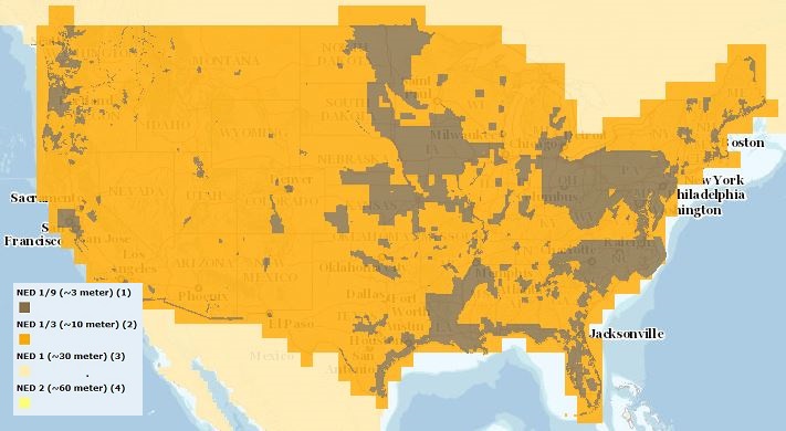
The USGS Elevation Availability service from The National Map (TNM) shows the best available resolution of downloadable elevation data, and is updated approximately every two weeks with National Elevation Dataset (NED) releases. NED 2- (in Alaska only), 1-, and 1/3-arc-second data are staged for download by 1x1 degree tiles in ArcGrid, GridFloat, or IMG formats in The National Map viewer, while NED 1/9 arc-second data is staged by 15x15 minute tiles in IMG format only. For additional information on the NED, go to http://ned.usgs.gov/.
Summary
The USGS Elevation Availability service from The National Map (TNM) shows the best available resolution of downloadable elevation data, and is updated approximately every two weeks with National Elevation Dataset (NED) releases. NED 2- (in Alaska only), 1-, and 1/3-arc-second data are staged for download by 1x1 degree tiles in ArcGrid, GridFloat, or IMG formats in The National Map viewer, while NED 1/9 arc-second data is staged by 15x15 minute tiles in IMG format only. For additional information on the NED, go to http://ned.usgs.gov/.
This dynamic overlay map service provides visualization of the free data that is available for download from The National Map at http://viewer.nationalmap.gov/viewer.
Preview Image
Browse graphic showing availability over Topo base map with legend.