Lidar Point Cloud - USGS National Map 3DEP Downloadable Data Collection
Dates
Publication Date
2023
Start Date
2004
Citation
U.S. Geological Survey, 2023, Lidar Point Cloud - USGS National Map 3DEP Downloadable Data Collection: U.S. Geological Survey.
Summary
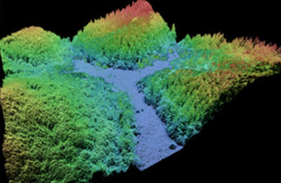
This data collection of the 3D Elevation Program (3DEP) consists of Lidar Point Cloud (LPC) projects as provided to the USGS. These point cloud files contain all the original lidar points collected, with the original spatial reference and units preserved. These data may have been used as the source of updates to the 1/3-arcsecond, 1-arcsecond, and 2-arcsecond seamless 3DEP Digital Elevation Models (DEMs). The 3DEP data holdings serve as the elevation layer of The National Map, and provide foundational elevation information for earth science studies and mapping applications in the United States. Lidar (Light detection and ranging) discrete-return point cloud data are available in LAZ format. The LAZ format is a lossless compressed version [...]
Summary
This data collection of the 3D Elevation Program (3DEP) consists of Lidar Point Cloud (LPC) projects as provided to the USGS. These point cloud files contain all the original lidar points collected, with the original spatial reference and units preserved. These data may have been used as the source of updates to the 1/3-arcsecond, 1-arcsecond, and 2-arcsecond seamless 3DEP Digital Elevation Models (DEMs). The 3DEP data holdings serve as the elevation layer of The National Map, and provide foundational elevation information for earth science studies and mapping applications in the United States. Lidar (Light detection and ranging) discrete-return point cloud data are available in LAZ format. The LAZ format is a lossless compressed version of the American Society for Photogrammetry and Remote Sensing (ASPRS) LAS format. Point Cloud data can be converted from LAZ to LAS or LAS to LAZ without the loss of any information. Either format stores 3-dimensional point cloud data and point attributes along with header information and variable length records specific to the data. Millions of data points are stored as a 3-dimensional data cloud as a series of geo-referenced x, y coordinates and z (elevation), as well as other attributes for each point. Please refer to https://www.asprs.org/Committee-General/LASer-LAS-File-Format-Exchange-Activities.html for additional information on the .LAS file format. All 3DEP products are public domain.
High-resolution digital elevation data generated by airborne lidar have led to significant advances in geomorphology, the branch of geoscience concerned with the origin and evolution of Earth's surface topography. Lidar provides unique characteristics relative to other remotely sensed data sources by providing three-dimensional feature information that cannot be derived from traditional imaging sensors. Lidar data serves as a source of data for the elevation layer of The National Map, and provides surface information for earth science studies and mapping applications in the United States. The data are utilized by the scientific and resource management communities for global change research, hydrologic modeling, resource monitoring, visualization, and other applications.