This dataset contains generalized landcover data for the Prairie Farm Rehabilitation Administration (PFRA) determined agricultural extent of Manitoba and Saskatchewan. This dataset was subset into two shapefiles. The other half of this dataset covers PFRA agricultural areas of Alberta and British Columbia. The Landcover Generalization process was undertaken to solve rendering problems of the original vectorized landcover data due to its unwieldy/overwhelming size. LANDSAT 7 imagery used in the process was collected during the WGTPP. This landcover imagery has a 30 meter resolution and is stored in over 1,100 vectorized 1:50,000 map sheet tiles. The data requires over seven gigabytes of disc space. If the user wishes to view a specific [...]
Summary
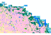
This dataset contains generalized landcover data for the Prairie Farm Rehabilitation Administration (PFRA) determined agricultural extent of Manitoba and Saskatchewan. This dataset was subset into two shapefiles. The other half of this dataset covers PFRA agricultural areas of Alberta and British Columbia.
The Landcover Generalization process was undertaken to solve rendering problems of the original vectorized landcover data due to its unwieldy/overwhelming size. LANDSAT 7 imagery used in the process was collected during the WGTPP. This landcover imagery has a 30 meter resolution and is stored in over 1,100 vectorized 1:50,000 map sheet tiles. The data requires over seven gigabytes of disc space. If the user wishes to view a specific area, they must identify the 1:50,000 map sheet, then browse to the desired mapsheet. Due to the great detail, this vector product (l02 in GIS_LIB) becomes computationally impossible on the desktop computer when multiple mapsheets are drawn. Spatial analysis and modeling at provincial or western Canada extents are also impossible in the mapsheet format.
The WGTPP Generalized Landcover is a seamless vector coverage, covering the agricultural extent of Western Canada. The generalized vector coverage is 124 MB in size, and requires roughly 60 times less space than the mapsheet tiles, thus making it easily used with desktop GIS applications. An algorithm was created using the processing tools of the ArcINFO GRID module. A series of AMLs and digital rules have been implemented in the event that new satellite imagery is acquired.
