2014 Water-Table Contours of the Mojave River and the Morongo Groundwater Basins, San Bernardino County, California (ver. 1.2, August 2020)
Dates
Publication Date
2016-06-28
Start Date
2014-01-01
End Date
2014-12-31
Revision
2017-04-17
Last Revision
2020-09-02
Citation
Teague, N.F., 2016, 2014 Water-Table Contours of the Mojave River and the Morongo Groundwater Basins, San Bernardino County, California (ver. 1.2, September 2020): U.S. Geological Survey data release, https://doi.org/10.5066/F7P848ZZ.
Summary
During 2014, the U.S. Geological Survey and other agencies made approximately 1,026 water-level measurements in the Mojave River and Morongo groundwater basins. These data document recent conditions and, when compared with previous data, changes in groundwater levels. A water-level contour map was drawn using data from about 610 wells, providing coverage for most of the basins. Twenty-four hydrographs show long-term (1930-2014) water-level conditions throughout the basins, and 9 short-term (1992 to 2014) hydrographs show the effects of recharge and discharge along the Mojave River. In addition, a water-level-change map was compiled to compare was compiled to compare the 2014 water levels to the 2012 water levels throughout the basins [...]
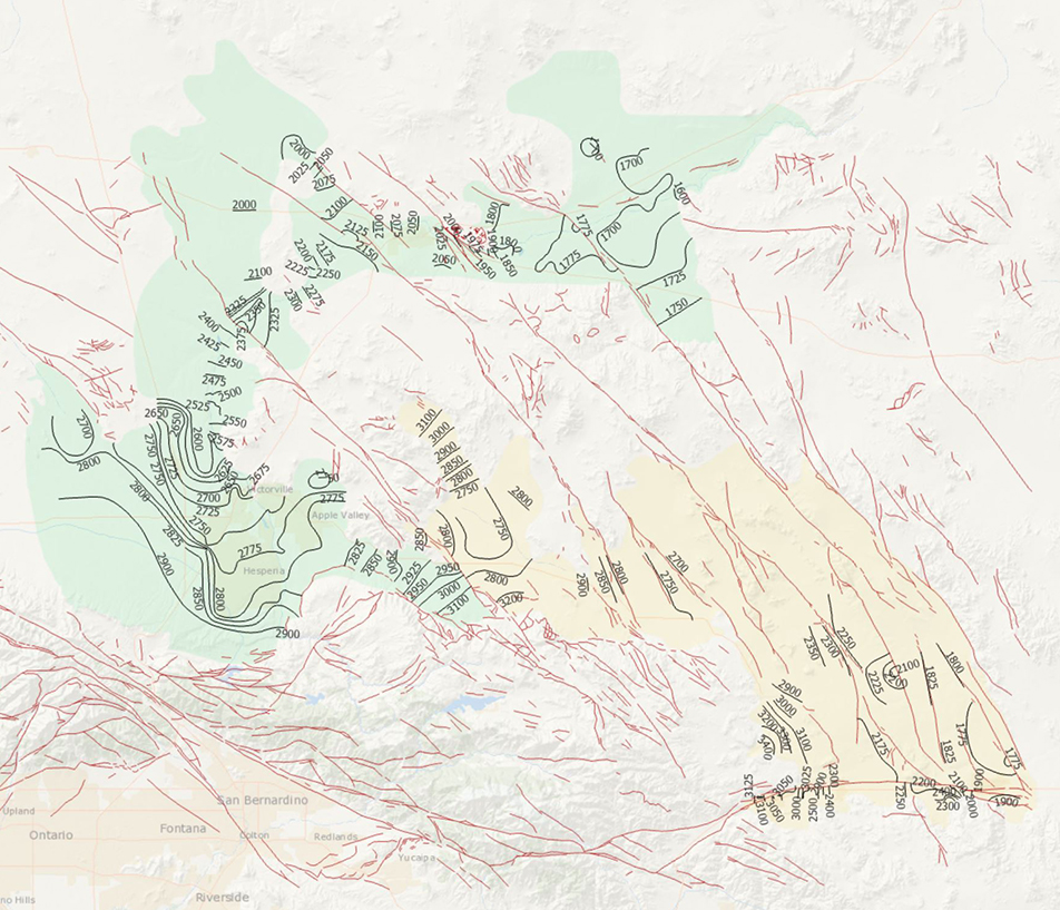
Summary
During 2014, the U.S. Geological Survey and other agencies made approximately 1,026 water-level measurements in the Mojave River and Morongo groundwater basins. These data document recent conditions and, when compared with previous data, changes in groundwater levels. A water-level contour map was drawn using data from about 610 wells, providing coverage for most of the basins. Twenty-four hydrographs show long-term (1930-2014) water-level conditions throughout the basins, and 9 short-term (1992 to 2014) hydrographs show the effects of recharge and discharge along the Mojave River. In addition, a water-level-change map was compiled to compare was compiled to compare the 2014 water levels to the 2012 water levels throughout the basins (479 wells).
This data set is a digital representation of the 2014 contours presented on Plate 1 of Regional Water Table (2014) in the Mojave River and Morongo Groundwater Basins, Southwestern Mojave Desert, California: U.S. Geological Survey Data Set, doi:10.5066/F7P848ZZ, published by Nick F. Teague, Christina L. Stamos, Sally F. House, and Dennis A. Clark. It is a continuation of a study first published in 2007. The initial version of the SIR includes data for 1992 to 2008 (SIR 2007-5097).
Preview Image
2014 Mojave Region Water Level Contours (browse graphic)
Revision 1.2 by Meghan Dick on September 2, 2020. To review the changes that were made, see “2014 Contours v3 Data Release revisions” in the attached files section.