Filters: Contacts: {oldPartyId:10255} (X)
4 results (43ms)|
Filters
Date Range
Types Contacts
Categories Tag Types Tag Schemes |
The Air Force Research Laboratory (AFRL) is about 7 kilometers southwest of Boron, California, and covers 320 square kilometers of Edwards Air Force Base. The AFRL consists of 12 facilities for testing full-size rocket engines, engine components, and liquid and solid propellants. The historical release of contaminants from rocket test stands, evaporation ponds, burn pits, catch basins, and leaking waste-collection tanks has contaminated groundwater in the AFRL. Groundwater aquifers near the AFRL are mostly restricted to fractured granitic bedrock, but previous studies indicate that groundwater and associated contaminants have moved into alluvium to the north and northwest. The U.S. Geological Survey (USGS) and the...
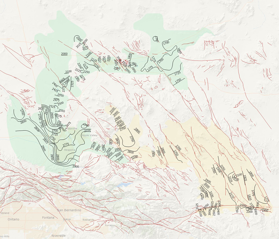
During 2014, the U.S. Geological Survey and other agencies made approximately 1,026 water-level measurements in the Mojave River and Morongo groundwater basins. These data document recent conditions and, when compared with previous data, changes in groundwater levels. A water-level contour map was drawn using data from about 610 wells, providing coverage for most of the basins. Twenty-four hydrographs show long-term (1930-2014) water-level conditions throughout the basins, and 9 short-term (1992 to 2014) hydrographs show the effects of recharge and discharge along the Mojave River. In addition, a water-level-change map was compiled to compare was compiled to compare the 2014 water levels to the 2012 water levels...
Categories: Data Release - Revised;
Tags: USGS,
USGS Science Data Catalog (SDC),
contours,
drainage basin,
ground water,
Water levels were measured during March 2014 in wells in the Antelope Valley and Fremont Valley groundwater basins, southwestern Mojave Desert, California, in cooperation with the Antelope Valley-East Kern Water District, Palmdale Water District, and Littlerock Creek Irrigation District. These data document recent conditions and, when compared with previous data, changes in groundwater levels. A regional water-table map was constructed using data from about 200 wells.
This data release contains appendix C1 and appendix C2 for the USGS Scientific Investigations Report (SIR) titled Hydrologic and Geochemical Characterization of the Petaluma River Watershed, Sonoma County, California. Appendix C1 contains selected chemical and physical properties and inorganic constituents in samples from selected springs, and wells, Petaluma Valley watershed, Sonoma County, California, 1959-2015. Samples are presented from 66 groundwater wells, 3 springs, and 2 surface-water sites. Data samples were collected by the U.S. Geological Survey (USGS), California Department of Water Resources (CDWR), California Department of Health Services (CDPH), and the City of Petaluma as part of the study.
Categories: Data;
Tags: Hydrology,
Petaluma,
Petaluma River,
USGS Science Data Catalog (SDC),
Water Quality,
|

|
