Filters: Contacts: Nathaniel Roth (X)
8 results (51ms)|
Filters
Date Range
Contacts Tag Schemes |
Farmland Mapping and Monitoring Program data product for 2010 with all counties in the San Joaquin Valley, and available bordering counties.
Saline Soils with at least slightly saline conditions. Based on SSURGO data.

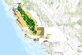
Hardwood forests of the San Joaquin Valley and surroundings

In late 1996, the Dept of Conservation (DOC) surveyed state and federal agencies about the county boundary coverage they used. As a result, DOC adopted the 1:24,000 (24K) scale U.S. Bureau of Reclamation (USBR) dataset (USGS source) for their Farmland Mapping and Monitoring Program (FMMP) but with several modifications. Detailed documentation of these changes is provided by FMMP and included in the lineage section of the metadata. A dataset named cnty24k97_1 was made available (approximately 2004) through the California Department of Forestry and Fire Protection - Fire and Resource Assessment Program (CDF - FRAP) and the California Spatial Information Library (CaSIL).In late 2006, the Department of Fish and Game...

These data identify the areas (in general) where final critical habitat for the species listed under the ESA occur

Individually displayed land use classes from the 2010 Farmland Mapping and Monitoring Program dataset.

Groundwater Rechargeable Soils based on NRCS soil data

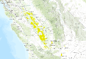
San Joaquin Valley Vernal Pool Complexes
|

|
