Filters: Categories: NOT Data (X) > Date Range: {"choice":"week"} (X)
39 results (136ms)|
Filters
Date Types (for Date Range)
Types Contacts
Categories Tag Types
|
We investigated the relative importance of groundwater (GW) and other local heat budget processes on downstream annual stream temperature signal characteristics using deterministic heat budget model (HFLUX) scenarios within an idealized stream reach representative of mountainous forested conditions. The purpose of this data release is to provide additional supplemental information for a published manuscript (Johnson et al., 2024). In this data release, we include (i) example input spreadsheets and an R script demonstrating how to read-in, edit, and export spreadsheet files without the need for a proprietary license, and (ii) MATLAB scripts necessary to run the HFLUX model and an example MATLAB script for developing...
This data release contains the concentration results for basic water-quality constituent class parameters (water temperature, pH, turbidity, and specific conductance), total nitrogen, total phosphorous, chloride, and trace elements in surface-water samples collected from two subsites within two vernal pools near Pleasant Grove, New Jersey in 2022-23. In the winter (December 2022 and February 2023) samples were collected at opposing ends of the ponds, or wherever ponding was sufficient for a sample to be taken. An additional sample was collected in July 2023 during the amphibian breeding season. The number of samples collected during each sampling event varied based on water availability and in July 2023 only one...
The Central Valley covers about 20,000 square miles and is one of the most productive agricultural regions in the world. Because the valley is semi-arid, surface-water availability varies substantially. Agricultural demand for irrigation is heavily reliant on surface water and groundwater. In the last few decades, land-use changes and limitations to surface-water availability—including drought and environmental flows—have increased pumping, causing groundwater-level and groundwater-storage declines, renewed subsidence, decreased stream flows, and changes to ecosystems. As these recent trends continue, monitoring, data compilation, and modeling are critical to understanding the dynamics of groundwater use and developing...
Categories: Project;
Types: Map Service,
OGC WFS Layer,
OGC WMS Layer,
OGC WMS Service;
Tags: Agricultural,
CVHM,
CVHM2,
California,
Central Valley,
This digital dataset includes three sets of observational data (groundwater level, streamflow, subsidence) used to calibrate the updated Central Valley Hydrologic Model (CVHM2)
Categories: Data Release - Revised;
Tags: California,
Central Valley,
Observation,
Streamflow,
Subsidence,
The data in this release were used to help evaluate and understand the distribution of fish and invertebrates as well as ecological response to streamflow, water temperature, and water chemistry within the Fountain Creek Basin. This data release consists of invertebrate data collected between 1985 and 2022, fish data collected between 2003 and 2022, as well as the data neccesary to recreate the tables and figures in the associated U.S. Geological Survey Scientific Investigations Report (http://dx.doi.org/10.3133/sirXXXXXXXX). See Zuellig and others (2022) for sampling methodology and site information.
Categories: Data Release - In Progress;
Tags: Aquatic biology,
Benthic environments,
Colorado,
Community ecology,
Ecology,

This model has been superseded by an updated version of the model. The new model can be found at: https://doi.org/10.5066/P99KJ1U1, https://doi.org/10.5066/P9FTZ5RW, https://doi.org/10.5066/P9NBWLYX, https://doi.org/10.5066/P97XBULI, https://doi.org/10.5066/P980EHWV, https://doi.org/10.5066/P95XLBB5, https://doi.org/10.5066/P9ICSZWF, https://doi.org/10.5066/P96LJ01V, and https://doi.org/10.5066/P9IZRO3V. A three-dimensional groundwater flow model (MODFLOW200-FMP1_1) of the Central Valley in California was developed to aid water managers in understanding how water moves through the aquifer system, to predict water-supply scenarios, and to address issues related to water competition. The USGS Groundwater Resources...
Categories: pre-SM502.8;
Tags: California,
Central Valley,
Corcoran Clay,
Groundwater,
Groundwater Model,
The U.S. Geological Survey (USGS), in cooperation with the Oklahoma Water Resources Board (OWRB), constructed a finite-difference numerical groundwater-flow model of the Washita River aquifer by using MODFLOW-2005 (Harbaugh, 2005) with the Newton formulation solver (MODFLOW-NWT). The 1973 Oklahoma Groundwater Law requires that the OWRB conduct hydrologic investigations of the State’s aquifers to determine the maximum annual yield (MAY) for each groundwater basin. The MAY is defined as the total amount of fresh groundwater that can be annually withdrawn while allowing a minimum 20-year life of that groundwater basin. For alluvium and terrace groundwater basins, the life requirement is satisfied if, after 20 years...
Model Inputs: Midwest Climate Change Vulnerability Assessment for the U.S. Fish and Wildlife Service
This data release contains the climate change model inputs and Soil and Water Assessment Tool (SWAT) model outputs from 360 HUC-8 watersheds in the Midwest United States (Illinois, Indiana, Iowa, Michigan, Minnesota, Ohio, and Wisconsin), that were generated using the HAWQS (Hydrologic and Water Quality System) platform (https://hawqs.tamu.edu). The summarized data for a watershed-based climate change vulnerability assessment for U.S. Fish and Wildlife Service is also provided, along with the R code used to summarize the raw outputs. Watershed-based Midwest Climate Change Vulnerability Assessment Tool: https://rconnect.usgs.gov/CC_Vulnerabi
The Central Valley, and particularly the San Joaquin Valley, has a long history of land subsidence caused by groundwater development. The extensive withdrawal of groundwater from the unconsolidated deposits of the San Joaquin Valley lowered groundwater levels and caused widespread land subsidence—reaching 9 meters by 1981. More than half of the thickness of the aquifer system is composed of fine-grained sediments, including clays, silts, and sandy or silty clays that are susceptible to compaction. In an effort to aid water managers in understanding how water moves through the aquifer system, predicting water-supply scenarios, and addressing issues related to water competition, the United States Geological Survey...

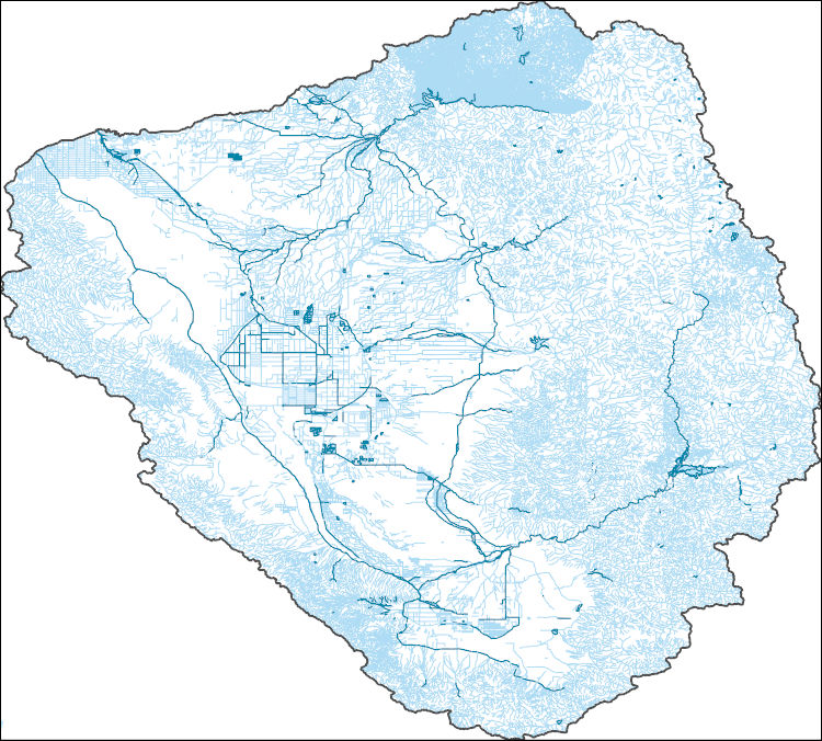
The High Resolution National Hydrography Dataset Plus (NHDPlus HR) is an integrated set of geospatial data layers, including the best available National Hydrography Dataset (NHD), the 10-meter 3D Elevation Program Digital Elevation Model (3DEP DEM), and the National Watershed Boundary Dataset (WBD). The NHDPlus HR combines the NHD, 3DEP DEMs, and WBD to create a stream network with linear referencing, feature naming, "value added attributes" (VAAs), elevation-derived catchments, and other features for hydrologic data analysis. The stream network with linear referencing is a system of data relationships applied to hydrographic systems so that one stream reach "flows" into another and "events" can be tied to and traced...

The High Resolution National Hydrography Dataset Plus (NHDPlus HR) is an integrated set of geospatial data layers, including the best available National Hydrography Dataset (NHD), the 10-meter 3D Elevation Program Digital Elevation Model (3DEP DEM), and the National Watershed Boundary Dataset (WBD). The NHDPlus HR combines the NHD, 3DEP DEMs, and WBD to create a stream network with linear referencing, feature naming, "value added attributes" (VAAs), elevation-derived catchments, and other features for hydrologic data analysis. The stream network with linear referencing is a system of data relationships applied to hydrographic systems so that one stream reach "flows" into another and "events" can be tied to and traced...

The High Resolution National Hydrography Dataset Plus (NHDPlus HR) is an integrated set of geospatial data layers, including the best available National Hydrography Dataset (NHD), the 10-meter 3D Elevation Program Digital Elevation Model (3DEP DEM), and the National Watershed Boundary Dataset (WBD). The NHDPlus HR combines the NHD, 3DEP DEMs, and WBD to create a stream network with linear referencing, feature naming, "value added attributes" (VAAs), elevation-derived catchments, and other features for hydrologic data analysis. The stream network with linear referencing is a system of data relationships applied to hydrographic systems so that one stream reach "flows" into another and "events" can be tied to and traced...

The High Resolution National Hydrography Dataset Plus (NHDPlus HR) is an integrated set of geospatial data layers, including the best available National Hydrography Dataset (NHD), the 10-meter 3D Elevation Program Digital Elevation Model (3DEP DEM), and the National Watershed Boundary Dataset (WBD). The NHDPlus HR combines the NHD, 3DEP DEMs, and WBD to create a stream network with linear referencing, feature naming, "value added attributes" (VAAs), elevation-derived catchments, and other features for hydrologic data analysis. The stream network with linear referencing is a system of data relationships applied to hydrographic systems so that one stream reach "flows" into another and "events" can be tied to and traced...
Wind speed, wind direction (3D) and gas concentrations are measured at 10 Hz and statistically processed using the eddy covariance technique to half-hour estimates of flux rates of gas exchange between the ecosystem and atmosphere. Three gases were measured: carbon dioxide, methane and water vapor. Simultaneous measurements of environmental drivers are also measured and recorded as half-hourly values: photosynthetic photon flux density, downwelling and upwelling short and long wave radiation, air temperature, relative humidity and precipitation. Variable names and units follow AmeriFlux and FLUXNET standards. This site is a flotant herbaceous freshwater marsh in Salvador Wildlife Management Area near Luling, LA.

The High Resolution National Hydrography Dataset Plus (NHDPlus HR) is an integrated set of geospatial data layers, including the best available National Hydrography Dataset (NHD), the 10-meter 3D Elevation Program Digital Elevation Model (3DEP DEM), and the National Watershed Boundary Dataset (WBD). The NHDPlus HR combines the NHD, 3DEP DEMs, and WBD to create a stream network with linear referencing, feature naming, "value added attributes" (VAAs), elevation-derived catchments, and other features for hydrologic data analysis. The stream network with linear referencing is a system of data relationships applied to hydrographic systems so that one stream reach "flows" into another and "events" can be tied to and traced...
Wind speed, wind direction (3D) and gas concentrations are measured at 10 Hz and statistically processed using the eddy covariance technique to half-hour estimates of flux rates of gas exchange between the ecosystem and atmosphere. Three gases were measured: carbon dioxide, methane and water vapor. Simultaneous measurements of environmental drivers are also measured and recorded as half-hourly values: photosynthetic photon flux density, downwelling and upwelling short and long wave radiation, air temperature, relative humidity and precipitation. Variable names and units follow AmeriFlux and FLUXNET standards. This site is a saltwater herbaceous marsh near Lake Hermitage, LA and Barataria Bay.
The High Resolution National Hydrography Dataset Plus (NHDPlus HR) is an integrated set of geospatial data layers, including the best available National Hydrography Dataset (NHD), the 10-meter 3D Elevation Program Digital Elevation Model (3DEP DEM), and the National Watershed Boundary Dataset (WBD). The NHDPlus HR combines the NHD, 3DEP DEMs, and WBD to create a stream network with linear referencing, feature naming, "value added attributes" (VAAs), elevation-derived catchments, and other features for hydrologic data analysis. The stream network with linear referencing is a system of data relationships applied to hydrographic systems so that one stream reach "flows" into another and "events" can be tied to and traced...
The High Resolution National Hydrography Dataset Plus (NHDPlus HR) is an integrated set of geospatial data layers, including the best available National Hydrography Dataset (NHD), the 10-meter 3D Elevation Program Digital Elevation Model (3DEP DEM), and the National Watershed Boundary Dataset (WBD). The NHDPlus HR combines the NHD, 3DEP DEMs, and WBD to create a stream network with linear referencing, feature naming, "value added attributes" (VAAs), elevation-derived catchments, and other features for hydrologic data analysis. The stream network with linear referencing is a system of data relationships applied to hydrographic systems so that one stream reach "flows" into another and "events" can be tied to and traced...
Climate adaptation planning provides a framework for Tribes to exercise sovereignty over wild resources important for the subsistence way of life and economic and cultural activities that are being impacted by climate change. The climate adaptation planning process includes identifying key resources that are currently being impacted by climate change, or that may be impacted in the future, as well as identifying practical and strategic steps that can be taken to mitigate or adapt to the changing circumstances. Through a partnership among the Ketchikan Indian Community, the Metlakatla Indian Community, OceansAlaska, and the University of Alaska Fairbanks this project will support Tribal- and Alaska Native-led...
Categories: Project;
Types: Map Service,
OGC WFS Layer,
OGC WMS Layer,
OGC WMS Service;
Tags: 2022,
Alaska,
Alaska CASC,
Alaska Natives and Corporations,
Alaska Natives and Corporations,

The High Resolution National Hydrography Dataset Plus (NHDPlus HR) is an integrated set of geospatial data layers, including the best available National Hydrography Dataset (NHD), the 10-meter 3D Elevation Program Digital Elevation Model (3DEP DEM), and the National Watershed Boundary Dataset (WBD). The NHDPlus HR combines the NHD, 3DEP DEMs, and WBD to create a stream network with linear referencing, feature naming, "value added attributes" (VAAs), elevation-derived catchments, and other features for hydrologic data analysis. The stream network with linear referencing is a system of data relationships applied to hydrographic systems so that one stream reach "flows" into another and "events" can be tied to and traced...
|

|
