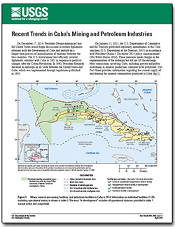
Filters: Categories: Publication (X) > partyWithName: U.S. Geological Survey (X)
412 results (130ms)|
Filters
|

U.S. GEOLOGICAL SURVEY Fact Sheet 94-074 Una traducción de este informe está disponible en español Accounting for Consumptive Use of Lower Colorado River Water in Arizona, California, Nevada, and Utah By Sandra J. Owen-Joyce and Richard P. Wilson LOWER COLORADO RIVER In the Colorado River valley between the east end of Lake Mead and the international boundary with Mexico (see figure), the river is the principal source of water for agricultural, domestic, municipal, industrial, hydroelectric-power generation, and recreational purposes. Water is stored in surface reservoirs and in the river aquifer---permeable sediments and sedimentary rocks that fill the lower Colorado River valley and adjacent tributary valleys....
Categories: Publication;
Tags: Consumptive use of Lower Colorado River
Categories: Publication;
Types: Citation

Groundwater resources in Cape Verde provide water for agriculture, industry, and human consumption. These resources are limited and susceptible to contamination. Additional groundwater resources are needed for continued agricultural development, particularly during times of drought, but increased use and (or) climatic change may have adverse effects on the quantity and quality of freshwater available. In volcanic island aquifers such as those of Cape Verde, a lens of fresh groundwater typically ?floats? upon a layer of brackish water at the freshwater/saltwater boundary, and increased pumping may cause salt water intrusion or other contamination. A recent U.S. Geological Survey study assessed baseline groundwater...
Categories: Publication;
Types: Citation
Categories: Publication;
Types: Citation
Ground-water flow was simulated using variable-direction anisotropy in hydraulic conductivity to represent the folded, fractured sedimentary rocks that underlie the Shenandoah Valley in Virginia and West Virginia. The anisotropy is a consequence of the orientations of fractures that provide preferential flow paths through the rock, such that the direction of maximum hydraulic conductivity is oriented within bedding planes, which generally strike N30 deg E; the direction of minimum hydraulic conductivity is perpendicular to the bedding. The finite-element model SUTRA was used to specify variable directions of the hydraulic-conductivity tensor in order to represent changes in the strike and dip of the bedding throughout...
Categories: Publication;
Types: Citation
In 1983, a snowmelt energy budget study was initiated by the U.S. Geological Survey on a small watershed near Rabbit Ears Pass, Colorado, to better understand snowmelt processes. The study included data collection from hydrological and meteorological instrumentation. Interest in long term, high-altitude meteorological sites has increased recently due to the increased awareness of global climate change. The meteorological data collected near Rabbit Ears Pass may aid researchers involved in global climate change studies. Meteorological data from 1984 to 2008 are presented.
Categories: Publication;
Types: Citation
Groundwater resources in the United States are under ever-increasing demands for potable, irrigation, and recreational uses. Additionally, aquifer systems are being used or targeted for use as storage areas for treated surface waters and (or) groundwaters via injection (for example, aquifer storage and recovery). To date, the influence that the nutrients, including carbon, in the injected water have on native microbial communities and the biogeochemistry in the subsurface zones used for storage of the injectate has not been determined. In this report, we describe a series of experiments that establishes a baseline dataset for the quantity and quality of organic and inorganic carbon and nutrients in the Biscayne...
Categories: Publication;
Types: Citation
The U.S. Geological Survey (USGS) investigated the natural attenuation of subsurface petroleum hydrocarbons leaked over an unknown number of years from an oil pipeline under the Enbridge Energy Limited Partnership South Cass Lake Pumping Station, in Cass Lake, Minnesota. Three weeks of field work conducted between May 2007 and July 2008 delineated a dissolved plume of aromatic hydrocarbons and characterized the biodegradation processes of the petroleum. Field activities included installing monitoring wells, collecting sediment cores, sampling water from wells, and measuring water-table elevations. Geochemical measurements included concentrations of constituents in both spilled and pipeline oil, dissolved alkylbenzenes...
Categories: Publication;
Types: Citation
Waste byproducts associated with operations at the Idaho Nuclear Technology and Engineering Center (INTEC) have the potential to contaminate the eastern Snake River Plain (ESRP) aquifer. Recharge to the ESRP aquifer is controlled largely by the alternating stratigraphy of fractured volcanic rocks and sedimentary interbeds within the overlying vadose zone and by the availability of water at the surface. Beneath the INTEC facilities, localized zones of saturation perched on the sedimentary interbeds are of particular concern because they may facilitate accelerated transport of contaminants. The sources and timing of natural and anthropogenic recharge to the perched zones are poorly understood. Simple approaches for...
Categories: Publication;
Types: Citation
The purpose of the Reston Stable Isotope Laboratory (RSIL) lab code 1949 is to determine the δ(34S/32S), abbreviated as δ34S, of dissolved sulfate having a concentration less than 20 milligrams per liter. Dissolved sulfate is collected on an anion-exchange resin in the field, eluted in the laboratory with 3 M KCl, and precipitated with BaCl2 at pH 3 to 4 as BaSO4. The precipitated BaSO4 is filtered and dried before introduction into an elemental analyzer (EA) Carlo Erba NC 2500. The EA is used to convert sulfur in a BaSO4 solid sample into SO2 gas, and the EA is connected to a continuous flow isotope-ratio mass spectrometer (CF-IRMS), which determines differences in the isotope-amount ratios of stable sulfur isotopes...
Categories: Publication;
Types: Citation
This report presents surface water and surface (top 0-2 cm) sediment geochemical data collected during 2005-2006, as part of a larger study of mercury (Hg) dynamics in seasonal and permanently flooded wetland habitats within the lower Sacramento River basin, Yolo County, California. The study was conducted in two phases. Phase I represented reconnaissance sampling and included three locations within the Cache Creek drainage basin; two within the Cache Creek Nature Preserve (CCNP) and one in the Cache Creek Settling Basin (CCSB) within the creek‘s main channel near the southeast outlet to the Yolo Bypass. Two additional downstream sites within the Yolo Bypass Wildlife Area (YBWA) were also sampled during Phase I,...
Categories: Publication;
Types: Citation
A study by the U.S. Geological Survey (USGS) evaluated the hydrologic response to different projected carbon emission scenarios of the 21st century using a hydrologic simulation model. This study involved five major steps: (1) setup, calibrate and evaluated the Precipitation Runoff Modeling System (PRMS) model in 14 basins across the United States by local USGS personnel; (2) acquire selected simulated carbon emission scenarios from the World Climate Research Programme‘s Coupled Model Intercomparison Project; (3) statistical downscaling of these scenarios to create PRMS input files which reflect the future climatic conditions of these scenarios; (4) generate PRMS projections for the carbon emission scenarios for...
Categories: Publication;
Types: Citation
Whooping cranes (Grus americana) of the Aransas-Wood Buffalo population migrate twice each year through the Great Plains in North America. Recovery activities for this endangered species include providing adequate places to stop and rest during migration, which are generally referred to as stopover sites. To assist in recovery efforts, initial estimates of stopover site use intensity are presented, which provide opportunity to identify areas across the migration range used more intensively by whooping cranes. We used location data acquired from 58 unique individuals fitted with platform transmitting terminals that collected global position system locations. Radio-tagged birds provided 2,158 stopover sites over 10...
Categories: Data,
Publication;
Types: Citation,
Downloadable,
GeoTIFF,
Map Service,
Raster;
Tags: North America,
biota,
birds,
endangered species,
migratory birds,

Categories: Publication;
Types: Citation,
Map Service,
OGC WFS Layer,
OGC WMS Layer,
OGC WMS Service;
Tags: Data Series
Raw data were collected in Shenandoah National Park during summer 2012. Air and temperature data were collected using temperature loggers at several stations throughout the park. These data were used in the publication of the manuscript "Accounting for groundwater influence on headwater stream thermal sensitivity to climate change" through the journal Ecological Applications. Water temperature data were collected at all 78 reach locations during the summer of 2012 (23 June–7 September). Temperature was measured every hour with a logger.
Categories: Data,
Publication;
Types: Citation,
Downloadable,
Map Service,
OGC WFS Layer,
OGC WMS Layer,
Shapefile;
Tags: Climatic change,
Ecological evaluation,
Fish habitats,
Ground water,
Shenandoah National Park,
Remote camera data on snow presence, snow depth, and wildlife detections on Moscow Mountain in Latah County, ID, USA. Reconyx Hyperfire I and Hyperfire II cameras were used and set to take hourly timelapse images and motion-triggered images. The cameras were deployed from October 2020 - May 2021. Snow presence was assessed up to 15 m from the camera. Snow depth was measured using virtual snow stakes created with the edger R package created by the author. Wildlife were marked as present in all photos in which they appear, and new individuals were counted. Snow density was collected using a federal or prairie snow sampler. Snow hardness was collected using a ram penetrometer. Solar radiation was calculated using hemispherical...
Categories: Data,
Publication;
Types: Citation;
Tags: Idaho,
Latah,
Moscow Mountain,
Odocoileus hemionus,
Odocoileus virginianus,
|

|
