Filters: Tags: {"scheme":"GCMD Science keywords"} (X)
12 results (96ms)|
Filters
Date Range
Types (Less) Contacts (Less)
Tag Types Tags (with Scheme=GCMD Science keywords) |

This map layer shows elevation contour lines for Hawaii. The map layer was derived from the 100-meter resolution elevation data set which is published by the National Atlas of the United States, and is in the same Albers Equal-area Conic projection as that source data set. Contour intervals match the steps used in the National Atlas Color-Sliced Elevation data sets. Contours were adjusted so that they are in the proper relationship to National Atlas 1:1,000,000-scale lakes, reservoirs, and wide (double-line) streams.

This map layer shows elevation contour lines for Alaska. The map layer was derived from the 100-meter resolution elevation data set which is published by the National Atlas of the United States, and is in the same Albers Equal-area Conic projection as that source data set. Contour intervals match the steps used in the National Atlas Color-Sliced Elevation data sets. Contours were adjusted so that they are in the proper relationship to National Atlas 1:1,000,000-scale lakes, reservoirs, and wide (double-line) streams.
The 2020 North American Land Cover 30-meter dataset was produced as part of the North American Land Change Monitoring System (NALCMS), a trilateral effort between Natural Resources Canada, the United States Geological Survey, and three Mexican organizations including the National Institute of Statistics and Geography (Instituto Nacional de Estadística y Geografía), National Commission for the Knowledge and Use of the Biodiversity (Comisión Nacional Para el Conocimiento y Uso de la Biodiversidad), and the National Forestry Commission of Mexico (Comisión Nacional Forestal). The collaboration is facilitated by the Commission for Environmental Cooperation, an international organization created by the Canada, Mexico,...
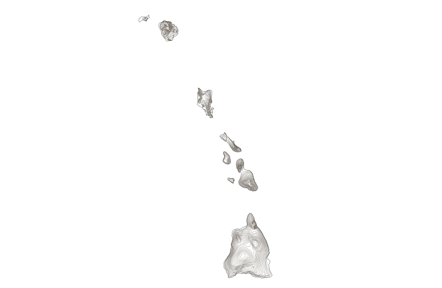
This map layer shows elevation contour lines for Hawaii. The map layer was derived from the 100-meter resolution elevation data set which is published by the National Atlas of the United States, and is in the same Albers Equal-area Conic projection as that source data set. Contour intervals match the steps used in the National Atlas Color-Sliced Elevation data sets. Contours were adjusted so that they are in the proper relationship to National Atlas 1:1,000,000-scale lakes, reservoirs, and wide (double-line) streams.
This data set replaces the 2010 edition (Edition 1.0) of the 2005 Land Cover of North America. Following the release of the first 2005 land cover data, several errors were identified in the data, including both errors in labeling and misinterpretation of thematic classes. To correct the labeling errors, each country focused on its national territory and corrected the errors which it considered most critical or misleading. For the continental data sets (including surrounding water fringe) 17440830 pixels (4.33% of the area) changed in the update. The following national counts exclude the water fringe: Canada, 10223412 pixels changed (6.44%); Mexico, 141142 pixels changed (0.45%), and U.S., 6878656 pixels changed...

This map layer shows elevation contour lines for the conterminous United States. The map layer was derived from the 100-meter resolution elevation data set which is published by the National Atlas of the United States, and is in the same Albers Equal-area Conic projection as that source data set. Contour intervals match the steps used in the National Atlas Color-Sliced Elevation data sets. Contours were adjusted so that they are in the proper relationship to National Atlas 1:1,000,000-scale lakes, reservoirs, and wide (double-line) streams.
This data set shows areas where the land cover classification changed between 2005and 2010. The 2005-2010 Land Cover Change of North America at 250 meters wasproduced as part of the North American Land Change Monitoring System (NALCMS), atrilateral effort between the Canada Centre for Remote Sensing, the United StatesGeological Survey, and three Mexican organizations including the National Instituteof Statistics and Geography (Instituto Nacional de Estadistica y Geografia),National Commission for the Knowledge and Use of the Biodiversity (ComisiónNacional Para el Conocimiento y Uso de la Biodiversidad), and the National ForestryCommission of Mexico (Comisión Nacional Forestal). The collaboration isfacilitated by...
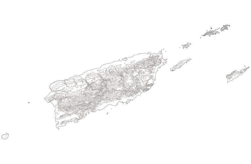
This map layer shows elevation contour lines for Puerto Rico and the U.S. Virgin Islands. The map layer was derived from the 100-meter resolution elevation data set which is published by the National Atlas of the United States, and is in the same Albers Equal-area Conic projection as that source data set. Contour intervals match the steps used in the National Atlas Color-Sliced Elevation data sets. Contours were adjusted so that they are in the proper relationship to National Atlas 1:1,000,000-scale lakes, reservoirs, and wide (double-line) streams.

This map layer shows elevation contour lines for the conterminous United States. The map layer was derived from the 100-meter resolution elevation data set which is published by the National Atlas of the United States, and is in the same Albers Equal-area Conic projection as that source data set. Contour intervals match the steps used in the National Atlas Color-Sliced Elevation data sets. Contours were adjusted so that they are in the proper relationship to National Atlas 1:1,000,000-scale lakes, reservoirs, and wide (double-line) streams.
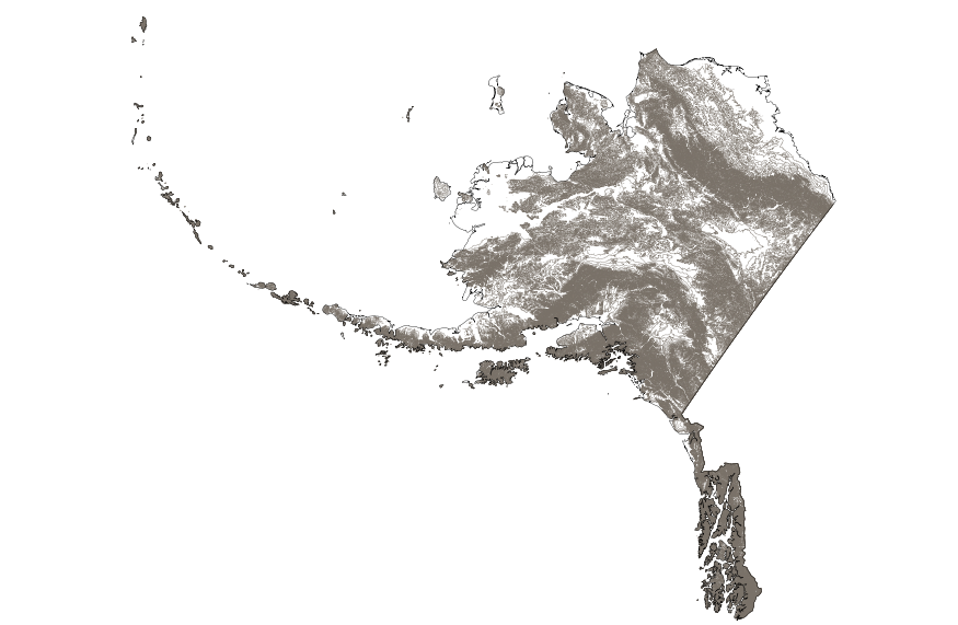
This map layer shows elevation contour lines for Alaska. The map layer was derived from the 100-meter resolution elevation data set which is published by the National Atlas of the United States, and is in the same Albers Equal-area Conic projection as that source data set. Contour intervals match the steps used in the National Atlas Color-Sliced Elevation data sets. Contours were adjusted so that they are in the proper relationship to National Atlas 1:1,000,000-scale lakes, reservoirs, and wide (double-line) streams.
The 2010 North American Land Cover data set was produced as part of the NorthAmerican Land Change Monitoring System (NALCMS), a trilateral effort between theCanada Centre for Remote Sensing, the United States Geological Survey, and threeMexican organizations including the National Institute of Statistics and Geography(Instituto Nacional de Estadistica y Geografia), National Commission for theKnowledge and Use of the Biodiversity (Comisión Nacional Para el Conocimiento yUso de la Biodiversidad), and the National Forestry Commission of Mexico (ComisiónNacional Forestal). The collaboration is facilitated by the Commission forEnvironmental Cooperation, an international organization created by the Canada,Mexico, and...

This map layer shows elevation contour lines for Puerto Rico and the U.S. Virgin Islands. The map layer was derived from the 100-meter resolution elevation data set which is published by the National Atlas of the United States, and is in the same Albers Equal-area Conic projection as that source data set. Contour intervals match the steps used in the National Atlas Color-Sliced Elevation data sets. Contours were adjusted so that they are in the proper relationship to National Atlas 1:1,000,000-scale lakes, reservoirs, and wide (double-line) streams.
|

|
