Filters: Tags: {"scheme":"USGS Publications Warehouse"} (X) > Categories: Publication (X)
119 results (130ms)|
Filters
Date Range
Extensions Types
Contacts
Categories Tag Types Tags (with Scheme=USGS Publications Warehouse) |


Categories: Publication;
Types: Citation,
Map Service,
OGC WFS Layer,
OGC WMS Layer,
OGC WMS Service;
Tags: Scientific Investigations Report

Categories: Publication;
Types: Citation,
Map Service,
OGC WFS Layer,
OGC WMS Layer,
OGC WMS Service;
Tags: Data Series
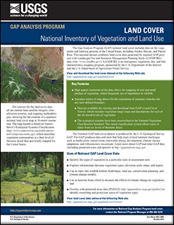
The Gap Analysis Program (GAP) produces data and tools that help meet critical national challenges such as biodiversity conservation, renewable energy development, climate change adaptation, and infrastructure investment. The GAP national land cover includes data on the vegetation and land-use patterns of the United States, including Alaska, Hawaii, and Puerto Rico. This national dataset combines land cover data generated by regional GAP projects with Landscape Fire and Resource Management Planning Tools (LANDFIRE) data. LANDFIRE is an interagency vegetation, fire, and fuel characteristics mapping program, sponsored by the U.S. Department of the Interior and the U.S. Department of Agriculture Forest Service.
Categories: Publication;
Types: Citation,
Map Service,
OGC WFS Layer,
OGC WMS Layer,
OGC WMS Service;
Tags: Data Series
Categories: Publication;
Types: Citation,
Map Service,
OGC WFS Layer,
OGC WMS Layer,
OGC WMS Service;
Tags: Scientific Investigations Report
|

|
