Filters: Tags: 10000 x 10000 meter (X) > Date Range: {"choice":"day"} (X)
1,020 results (70ms)|
Filters
Date Types (for Date Range)
Tag Types Tag Schemes |

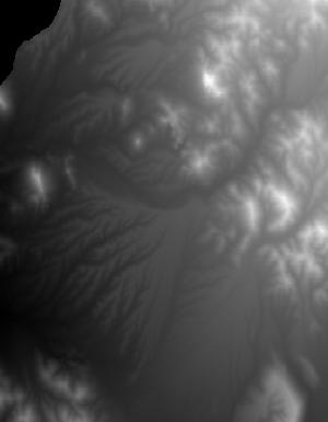
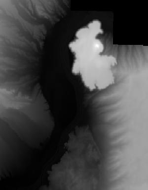
This is a tile of the standard one-meter resolution digital elevation model (DEM) produced through the 3D Elevation Program (3DEP) . The elevations in this DEM represent the topographic bare-earth surface. USGS standard one-meter DEMs are produced exclusively from high resolution light detection and ranging (lidar) source data of one-meter or higher resolution. One-meter DEM surfaces are seamless within collection projects, but, not necessarily seamless across projects. The spatial reference used for tiles of the one-meter DEM within the conterminous United States (CONUS) is Universal Transverse Mercator (UTM) in units of meters, and in conformance with the North American Datum of 1983 (NAD83). All bare earth elevation...

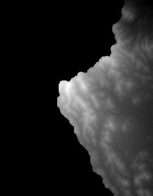
This is a tile of the standard one-meter resolution digital elevation model (DEM) produced through the 3D Elevation Program (3DEP) . The elevations in this DEM represent the topographic bare-earth surface. USGS standard one-meter DEMs are produced exclusively from high resolution light detection and ranging (lidar) source data of one-meter or higher resolution. One-meter DEM surfaces are seamless within collection projects, but, not necessarily seamless across projects. The spatial reference used for tiles of the one-meter DEM within the conterminous United States (CONUS) is Universal Transverse Mercator (UTM) in units of meters, and in conformance with the North American Datum of 1983 (NAD83). All bare earth elevation...

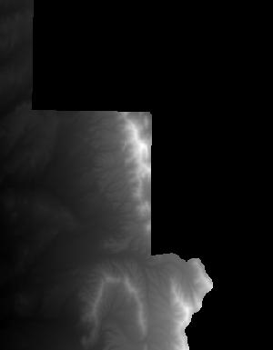
This is a tile of the standard one-meter resolution digital elevation model (DEM) produced through the 3D Elevation Program (3DEP) . The elevations in this DEM represent the topographic bare-earth surface. USGS standard one-meter DEMs are produced exclusively from high resolution light detection and ranging (lidar) source data of one-meter or higher resolution. One-meter DEM surfaces are seamless within collection projects, but, not necessarily seamless across projects. The spatial reference used for tiles of the one-meter DEM within the conterminous United States (CONUS) is Universal Transverse Mercator (UTM) in units of meters, and in conformance with the North American Datum of 1983 (NAD83). All bare earth elevation...

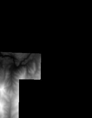
This is a tile of the standard one-meter resolution digital elevation model (DEM) produced through the 3D Elevation Program (3DEP) . The elevations in this DEM represent the topographic bare-earth surface. USGS standard one-meter DEMs are produced exclusively from high resolution light detection and ranging (lidar) source data of one-meter or higher resolution. One-meter DEM surfaces are seamless within collection projects, but, not necessarily seamless across projects. The spatial reference used for tiles of the one-meter DEM within the conterminous United States (CONUS) is Universal Transverse Mercator (UTM) in units of meters, and in conformance with the North American Datum of 1983 (NAD83). All bare earth elevation...
This is a tile of the standard one-meter resolution digital elevation model (DEM) produced through the 3D Elevation Program (3DEP) . The elevations in this DEM represent the topographic bare-earth surface. USGS standard one-meter DEMs are produced exclusively from high resolution light detection and ranging (lidar) source data of one-meter or higher resolution. One-meter DEM surfaces are seamless within collection projects, but, not necessarily seamless across projects. The spatial reference used for tiles of the one-meter DEM within the conterminous United States (CONUS) is Universal Transverse Mercator (UTM) in units of meters, and in conformance with the North American Datum of 1983 (NAD83). All bare earth elevation...

This is a tile of the standard one-meter resolution digital elevation model (DEM) produced through the 3D Elevation Program (3DEP) . The elevations in this DEM represent the topographic bare-earth surface. USGS standard one-meter DEMs are produced exclusively from high resolution light detection and ranging (lidar) source data of one-meter or higher resolution. One-meter DEM surfaces are seamless within collection projects, but, not necessarily seamless across projects. The spatial reference used for tiles of the one-meter DEM within the conterminous United States (CONUS) is Universal Transverse Mercator (UTM) in units of meters, and in conformance with the North American Datum of 1983 (NAD83). All bare earth elevation...

This is a tile of the standard one-meter resolution digital elevation model (DEM) produced through the 3D Elevation Program (3DEP) . The elevations in this DEM represent the topographic bare-earth surface. USGS standard one-meter DEMs are produced exclusively from high resolution light detection and ranging (lidar) source data of one-meter or higher resolution. One-meter DEM surfaces are seamless within collection projects, but, not necessarily seamless across projects. The spatial reference used for tiles of the one-meter DEM within the conterminous United States (CONUS) is Universal Transverse Mercator (UTM) in units of meters, and in conformance with the North American Datum of 1983 (NAD83). All bare earth elevation...
This is a tile of the standard one-meter resolution digital elevation model (DEM) produced through the 3D Elevation Program (3DEP) . The elevations in this DEM represent the topographic bare-earth surface. USGS standard one-meter DEMs are produced exclusively from high resolution light detection and ranging (lidar) source data of one-meter or higher resolution. One-meter DEM surfaces are seamless within collection projects, but, not necessarily seamless across projects. The spatial reference used for tiles of the one-meter DEM within the conterminous United States (CONUS) is Universal Transverse Mercator (UTM) in units of meters, and in conformance with the North American Datum of 1983 (NAD83). All bare earth elevation...

This is a tile of the standard one-meter resolution digital elevation model (DEM) produced through the 3D Elevation Program (3DEP) . The elevations in this DEM represent the topographic bare-earth surface. USGS standard one-meter DEMs are produced exclusively from high resolution light detection and ranging (lidar) source data of one-meter or higher resolution. One-meter DEM surfaces are seamless within collection projects, but, not necessarily seamless across projects. The spatial reference used for tiles of the one-meter DEM within the conterminous United States (CONUS) is Universal Transverse Mercator (UTM) in units of meters, and in conformance with the North American Datum of 1983 (NAD83). All bare earth elevation...

This is a tile of the standard one-meter resolution digital elevation model (DEM) produced through the 3D Elevation Program (3DEP) . The elevations in this DEM represent the topographic bare-earth surface. USGS standard one-meter DEMs are produced exclusively from high resolution light detection and ranging (lidar) source data of one-meter or higher resolution. One-meter DEM surfaces are seamless within collection projects, but, not necessarily seamless across projects. The spatial reference used for tiles of the one-meter DEM within the conterminous United States (CONUS) is Universal Transverse Mercator (UTM) in units of meters, and in conformance with the North American Datum of 1983 (NAD83). All bare earth elevation...

This is a tile of the standard one-meter resolution digital elevation model (DEM) produced through the 3D Elevation Program (3DEP) . The elevations in this DEM represent the topographic bare-earth surface. USGS standard one-meter DEMs are produced exclusively from high resolution light detection and ranging (lidar) source data of one-meter or higher resolution. One-meter DEM surfaces are seamless within collection projects, but, not necessarily seamless across projects. The spatial reference used for tiles of the one-meter DEM within the conterminous United States (CONUS) is Universal Transverse Mercator (UTM) in units of meters, and in conformance with the North American Datum of 1983 (NAD83). All bare earth elevation...
This is a tile of the standard one-meter resolution digital elevation model (DEM) produced through the 3D Elevation Program (3DEP) . The elevations in this DEM represent the topographic bare-earth surface. USGS standard one-meter DEMs are produced exclusively from high resolution light detection and ranging (lidar) source data of one-meter or higher resolution. One-meter DEM surfaces are seamless within collection projects, but, not necessarily seamless across projects. The spatial reference used for tiles of the one-meter DEM within the conterminous United States (CONUS) is Universal Transverse Mercator (UTM) in units of meters, and in conformance with the North American Datum of 1983 (NAD83). All bare earth elevation...
This is a tile of the standard one-meter resolution digital elevation model (DEM) produced through the 3D Elevation Program (3DEP) . The elevations in this DEM represent the topographic bare-earth surface. USGS standard one-meter DEMs are produced exclusively from high resolution light detection and ranging (lidar) source data of one-meter or higher resolution. One-meter DEM surfaces are seamless within collection projects, but, not necessarily seamless across projects. The spatial reference used for tiles of the one-meter DEM within the conterminous United States (CONUS) is Universal Transverse Mercator (UTM) in units of meters, and in conformance with the North American Datum of 1983 (NAD83). All bare earth elevation...

This is a tile of the standard one-meter resolution digital elevation model (DEM) produced through the 3D Elevation Program (3DEP) . The elevations in this DEM represent the topographic bare-earth surface. USGS standard one-meter DEMs are produced exclusively from high resolution light detection and ranging (lidar) source data of one-meter or higher resolution. One-meter DEM surfaces are seamless within collection projects, but, not necessarily seamless across projects. The spatial reference used for tiles of the one-meter DEM within the conterminous United States (CONUS) is Universal Transverse Mercator (UTM) in units of meters, and in conformance with the North American Datum of 1983 (NAD83). All bare earth elevation...

This is a tile of the standard one-meter resolution digital elevation model (DEM) produced through the 3D Elevation Program (3DEP) . The elevations in this DEM represent the topographic bare-earth surface. USGS standard one-meter DEMs are produced exclusively from high resolution light detection and ranging (lidar) source data of one-meter or higher resolution. One-meter DEM surfaces are seamless within collection projects, but, not necessarily seamless across projects. The spatial reference used for tiles of the one-meter DEM within the conterminous United States (CONUS) is Universal Transverse Mercator (UTM) in units of meters, and in conformance with the North American Datum of 1983 (NAD83). All bare earth elevation...

This is a tile of the standard one-meter resolution digital elevation model (DEM) produced through the 3D Elevation Program (3DEP) . The elevations in this DEM represent the topographic bare-earth surface. USGS standard one-meter DEMs are produced exclusively from high resolution light detection and ranging (lidar) source data of one-meter or higher resolution. One-meter DEM surfaces are seamless within collection projects, but, not necessarily seamless across projects. The spatial reference used for tiles of the one-meter DEM within the conterminous United States (CONUS) is Universal Transverse Mercator (UTM) in units of meters, and in conformance with the North American Datum of 1983 (NAD83). All bare earth elevation...

This is a tile of the standard one-meter resolution digital elevation model (DEM) produced through the 3D Elevation Program (3DEP) . The elevations in this DEM represent the topographic bare-earth surface. USGS standard one-meter DEMs are produced exclusively from high resolution light detection and ranging (lidar) source data of one-meter or higher resolution. One-meter DEM surfaces are seamless within collection projects, but, not necessarily seamless across projects. The spatial reference used for tiles of the one-meter DEM within the conterminous United States (CONUS) is Universal Transverse Mercator (UTM) in units of meters, and in conformance with the North American Datum of 1983 (NAD83). All bare earth elevation...
This is a tile of the standard one-meter resolution digital elevation model (DEM) produced through the 3D Elevation Program (3DEP) . The elevations in this DEM represent the topographic bare-earth surface. USGS standard one-meter DEMs are produced exclusively from high resolution light detection and ranging (lidar) source data of one-meter or higher resolution. One-meter DEM surfaces are seamless within collection projects, but, not necessarily seamless across projects. The spatial reference used for tiles of the one-meter DEM within the conterminous United States (CONUS) is Universal Transverse Mercator (UTM) in units of meters, and in conformance with the North American Datum of 1983 (NAD83). All bare earth elevation...

This is a tile of the standard one-meter resolution digital elevation model (DEM) produced through the 3D Elevation Program (3DEP) . The elevations in this DEM represent the topographic bare-earth surface. USGS standard one-meter DEMs are produced exclusively from high resolution light detection and ranging (lidar) source data of one-meter or higher resolution. One-meter DEM surfaces are seamless within collection projects, but, not necessarily seamless across projects. The spatial reference used for tiles of the one-meter DEM within the conterminous United States (CONUS) is Universal Transverse Mercator (UTM) in units of meters, and in conformance with the North American Datum of 1983 (NAD83). All bare earth elevation...

This is a tile of the standard one-meter resolution digital elevation model (DEM) produced through the 3D Elevation Program (3DEP) . The elevations in this DEM represent the topographic bare-earth surface. USGS standard one-meter DEMs are produced exclusively from high resolution light detection and ranging (lidar) source data of one-meter or higher resolution. One-meter DEM surfaces are seamless within collection projects, but, not necessarily seamless across projects. The spatial reference used for tiles of the one-meter DEM within the conterminous United States (CONUS) is Universal Transverse Mercator (UTM) in units of meters, and in conformance with the North American Datum of 1983 (NAD83). All bare earth elevation...
|

|
