Filters: Tags: 303d (X)
22 results (9ms)|
Filters
|

Vector file of 305b listed streams
The 303(d) Listed Impaired Waters program system provides impaired water data and impaired water features reflecting river segments, lakes, and estuaries designated under Section 303(d) of the Clean Water Act. Each State will establish Total Maximum Daily Loads (TMDLs) for these waters. Note the CWA Section 303(d) list of impaired waters does not represent waters that are impaired but have an EPA-approved TMDL established, impaired waters for which other pollution control mechanisms are in place and expected to attain water quality standards, or waters impaired as a result of pollution and is not caused by a pollutant. Therefore, the "Impaired Waters" layers do not represent all impaired waters reported in a state's...

The 303(d) Listed Impaired Waters program system provides impaired water data and impaired water features reflecting river segments, lakes, and estuaries designated under Section 303(d) of the Clean Water Act. Each State will establish Total Maximum Daily Loads (TMDLs) for these waters. Note the CWA Section 303(d) list of impaired waters does not represent waters that are impaired but have an EPA-approved TMDL established, impaired waters for which other pollution control mechanisms are in place and expected to attain water quality standards, or waters impaired as a result of pollution and is not caused by a pollutant; therefore, the "Impaired Waters" layers do not represent all impaired waters reported in a state's...
The 303(d) Listed Impaired Waters program system provides impaired water data and impaired water features reflecting river segments, lakes, and estuaries designated under Section 303(d) of the Clean Water Act. Each State will establish Total Maximum Daily Loads (TMDLs) for these waters. Note the CWA Section 303(d) list of impaired waters does not represent waters that are impaired but have an EPA-approved TMDL established, impaired waters for which other pollution control mechanisms are in place and expected to attain water quality standards, or waters impaired as a result of pollution and is not caused by a pollutant; therefore, the "Impaired Waters" layers do not represent all impaired waters reported in a state's...
The 303(d) Listed Impaired Waters program system provides impaired water data and impaired water features reflecting river segments, lakes, and estuaries designated under Section 303(d) of the Clean Water Act. Each State will establish Total Maximum Daily Loads (TMDLs) for these waters. Note the CWA Section 303(d) list of impaired waters does not represent waters that are impaired but have an EPA-approved TMDL established, impaired waters for which other pollution control mechanisms are in place and expected to attain water quality standards, or waters impaired as a result of pollution and is not caused by a pollutant; therefore, the "Impaired Waters" layers do not represent all impaired waters reported in a state's...
The 303(d) Listed Impaired Waters program provides impaired water data and impaired water features reflecting river segments, lakes, and estuaries designated under Section 303(d) of the Clean Water Act (CWA). Each State will establish Total Maximum Daily Loads (TMDLs) for these waters. Note the CWA Section 303(d) list of impaired waters does not represent waters that are impaired but have an established TMDL, impaired waters for which other pollution control mechanisms are in place and expected to attain water quality standards, or waters impaired as a result of pollution. Therefore, the "Impaired Waters" layers do not represent all impaired waters reported in a state's Integrated Report, but only the waters comprised...
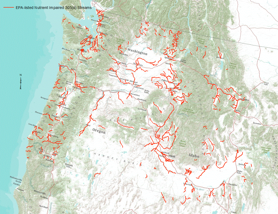
“Under section 303(d) of the 1972 Clean Water Act, states, territories, and authorized tribes are required to develop lists of impaired waters. These impaired waters do not meet water quality standards that states, territories, and authorized tribes have set for them, even after point sources of pollution have installed the minimum required levels of pollution control technology. The law requires that these jurisdictions establish priority rankings for waters on the lists and develop TMDLs for these waters” (U.S. Environmental Protection Agency, 2011). Waterways represented in this data set are a subset of these EPA 303 (d) listed streams that were classified as nutrient impaired. Nutrient impaired streams include...
The 303(d) Listed Impaired Waters program system provides impaired water data and impaired water features reflecting river segments, lakes, and estuaries designated under Section 303(d) of the Clean Water Act. Each State will establish Total Maximum Daily Loads (TMDLs) for these waters. Note the CWA Section 303(d) list of impaired waters does not represent waters that are impaired but have an EPA-approved TMDL established, impaired waters for which other pollution control mechanisms are in place and expected to attain water quality standards, or waters impaired as a result of pollution and is not caused by a pollutant; therefore, the "Impaired Waters" layers do not represent all impaired waters reported in a state's...
This map contains the data layers and layout showing the amount of 303d waterways per HUC 12 analysis unit. These data are provided by Bureau of Land Management (BLM) "as is" and may contain errors or omissions. The User assumes the entire risk associated with its use of these data and bears all responsibility in determining whether these data are fit for the User's intended use. These data may not have the accuracy, resolution, completeness, timeliness, or other characteristics appropriate for applications that potential users of the data may contemplate. The User is encouraged to carefully consider the content of the metadata file associated with these data. The BLM should be cited as the data source in any products...
The 303(d) Listed Impaired Waters program system provides impaired water data and impaired water features reflecting river segments, lakes, and estuaries designated under Section 303(d) of the Clean Water Act. Each State will establish Total Maximum Daily Loads (TMDLs) for these waters. Note the CWA Section 303(d) list of impaired waters does not represent waters that are impaired but have an EPA-approved TMDL established, impaired waters for which other pollution control mechanisms are in place and expected to attain water quality standards, or waters impaired as a result of pollution and is not caused by a pollutant. Therefore, the "Impaired Waters" layers do not represent all impaired waters reported in a state's...

These data were released prior to the October 1, 2016 effective date for the USGS’s policy dictating the review, approval, and release of scientific data as referenced in USGS Survey Manual Chapter 502.8 Fundamental Science Practices: Review and Approval of Scientific Data for Release. Under section 303(d) of the 1972 Clean Water Act, states, territories, and authorized tribes are required to develop lists of impaired waters. These impaired waters do not meet water quality standards that states, territories, and authorized tribes have set for them, even after point sources of pollution have installed the minimum required levels of pollution control technology. The law requires that these jurisdictions establish...

This map service contains GIS data from the EPA Office of Water 303(d) Program in Web Mercator. It is available as a WMS, KML and REST service as well as the native MapServer service.
The 303(d) Listed Impaired Waters program system provides impaired water data and impaired water features reflecting river segments, lakes, and estuaries designated under Section 303(d) of the Clean Water Act. Each State will establish Total Maximum Daily Loads (TMDLs) for these waters. Note the CWA Section 303(d) list of impaired waters does not represent waters that are impaired but have an EPA-approved TMDL established, impaired waters for which other pollution control mechanisms are in place and expected to attain water quality standards, or waters impaired as a result of pollution and is not caused by a pollutant. Therefore, the "Impaired Waters" layers do not represent all impaired waters reported in a state's...
The 303(d) Listed Impaired Waters program system provides impaired water data and impaired water features reflecting river segments, lakes, and estuaries designated under Section 303(d) of the Clean Water Act. Each State will establish Total Maximum Daily Loads (TMDLs) for these waters. Note the CWA Section 303(d) list of impaired waters does not represent waters that are impaired but have an EPA-approved TMDL established, impaired waters for which other pollution control mechanisms are in place and expected to attain water quality standards, or waters impaired as a result of pollution and is not caused by a pollutant; therefore, the "Impaired Waters" layers do not represent all impaired waters reported in a state's...
This map contains the data layers and layout showing the amount of 303d waterways per 4km analysis unit. These data are provided by Bureau of Land Management (BLM) "as is" and may contain errors or omissions. The User assumes the entire risk associated with its use of these data and bears all responsibility in determining whether these data are fit for the User's intended use. These data may not have the accuracy, resolution, completeness, timeliness, or other characteristics appropriate for applications that potential users of the data may contemplate. The User is encouraged to carefully consider the content of the metadata file associated with these data. The BLM should be cited as the data source in any products...
This map shows EPA 303(d) waterbodies and streams. These data are provided by Bureau of Land Management (BLM) "as is" and may contain errors or omissions. The User assumes the entire risk associated with its use of these data and bears all responsibility in determining whether these data are fit for the User's intended use. These data may not have the accuracy, resolution, completeness, timeliness, or other characteristics appropriate for applications that potential users of the data may contemplate. The User is encouraged to carefully consider the content of the metadata file associated with these data. The BLM should be cited as the data source in any products derived from these data.
The 303(d) Listed Impaired Waters program system provides impaired water data and impaired water features reflecting river segments, lakes, and estuaries designated under Section 303(d) of the Clean Water Act. Each State will establish Total Maximum Daily Loads (TMDLs) for these waters. Note the CWA Section 303(d) list of impaired waters does not represent waters that are impaired but have an EPA-approved TMDL established, impaired waters for which other pollution control mechanisms are in place and expected to attain water quality standards, or waters impaired as a result of pollution and is not caused by a pollutant. Therefore, the "Impaired Waters" layers do not represent all impaired waters reported in a state's...
The 303(d) Listed Impaired Waters program system provides impaired water data and impaired water features reflecting river segments, lakes, and estuaries designated under Section 303(d) of the Clean Water Act. Each State will establish Total Maximum Daily Loads (TMDLs) for these waters. Note the CWA Section 303(d) list of impaired waters does not represent waters that are impaired but have an EPA-approved TMDL established, impaired waters for which other pollution control mechanisms are in place and expected to attain water quality standards, or waters impaired as a result of pollution and is not caused by a pollutant. Therefore, the "Impaired Waters" layers do not represent all impaired waters reported in a state's...
The 303(d) Listed Impaired Waters program system provides impaired water data and impaired water features reflecting river segments, lakes, and estuaries designated under Section 303(d) of the Clean Water Act. Each State will establish Total Maximum Daily Loads (TMDLs) for these waters. Note the CWA Section 303(d) list of impaired waters does not represent waters that are impaired but have an EPA-approved TMDL established, impaired waters for which other pollution control mechanisms are in place and expected to attain water quality standards, or waters impaired as a result of pollution and is not caused by a pollutant; therefore, the "Impaired Waters" layers do not represent all impaired waters reported in a state's...
The 303(d) Listed Impaired Waters program system provides impaired water data and impaired water features reflecting river segments, lakes, and estuaries designated under Section 303(d) of the Clean Water Act. Each State will establish Total Maximum Daily Loads (TMDLs) for these waters. Note the CWA Section 303(d) list of impaired waters does not represent waters that are impaired but have an EPA-approved TMDL established, impaired waters for which other pollution control mechanisms are in place and expected to attain water quality standards, or waters impaired as a result of pollution and is not caused by a pollutant; therefore, the "Impaired Waters" layers do not represent all impaired waters reported in a state's...
|

|
