Filters
Date Range
Contacts
Tag Types
Tag Schemes
|
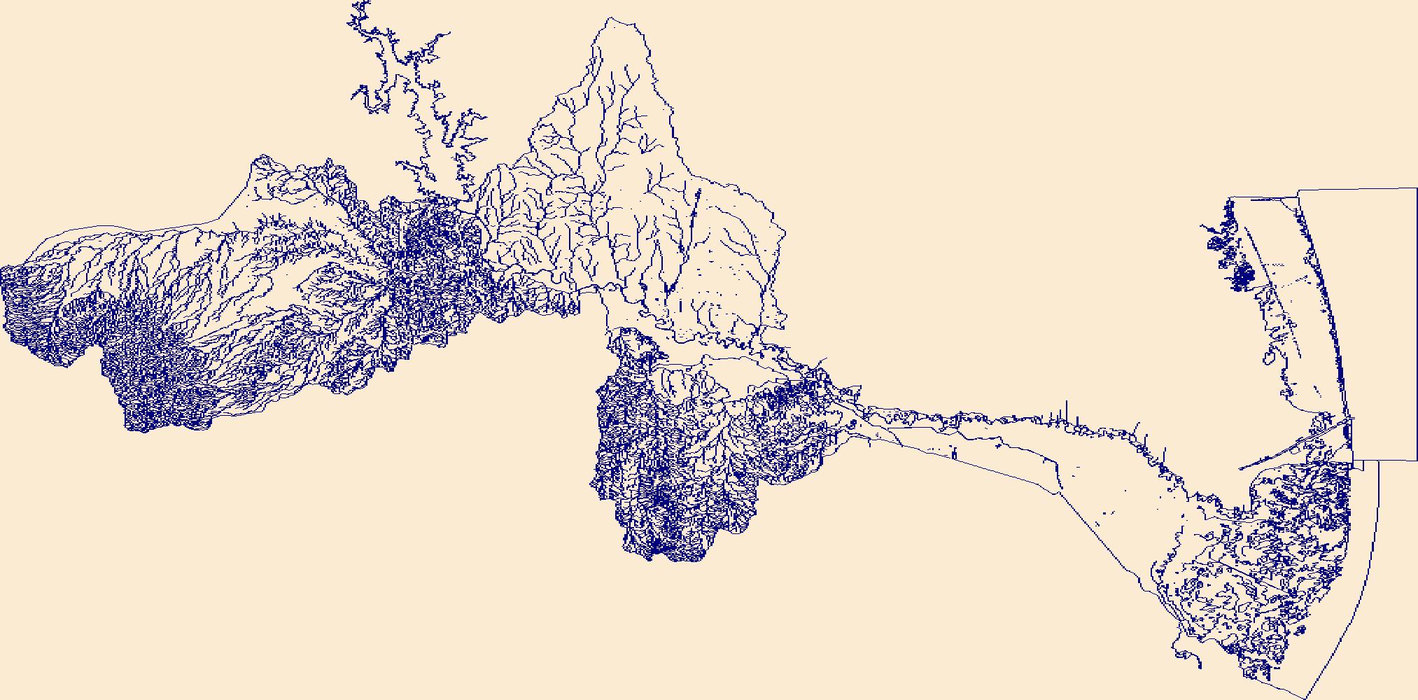
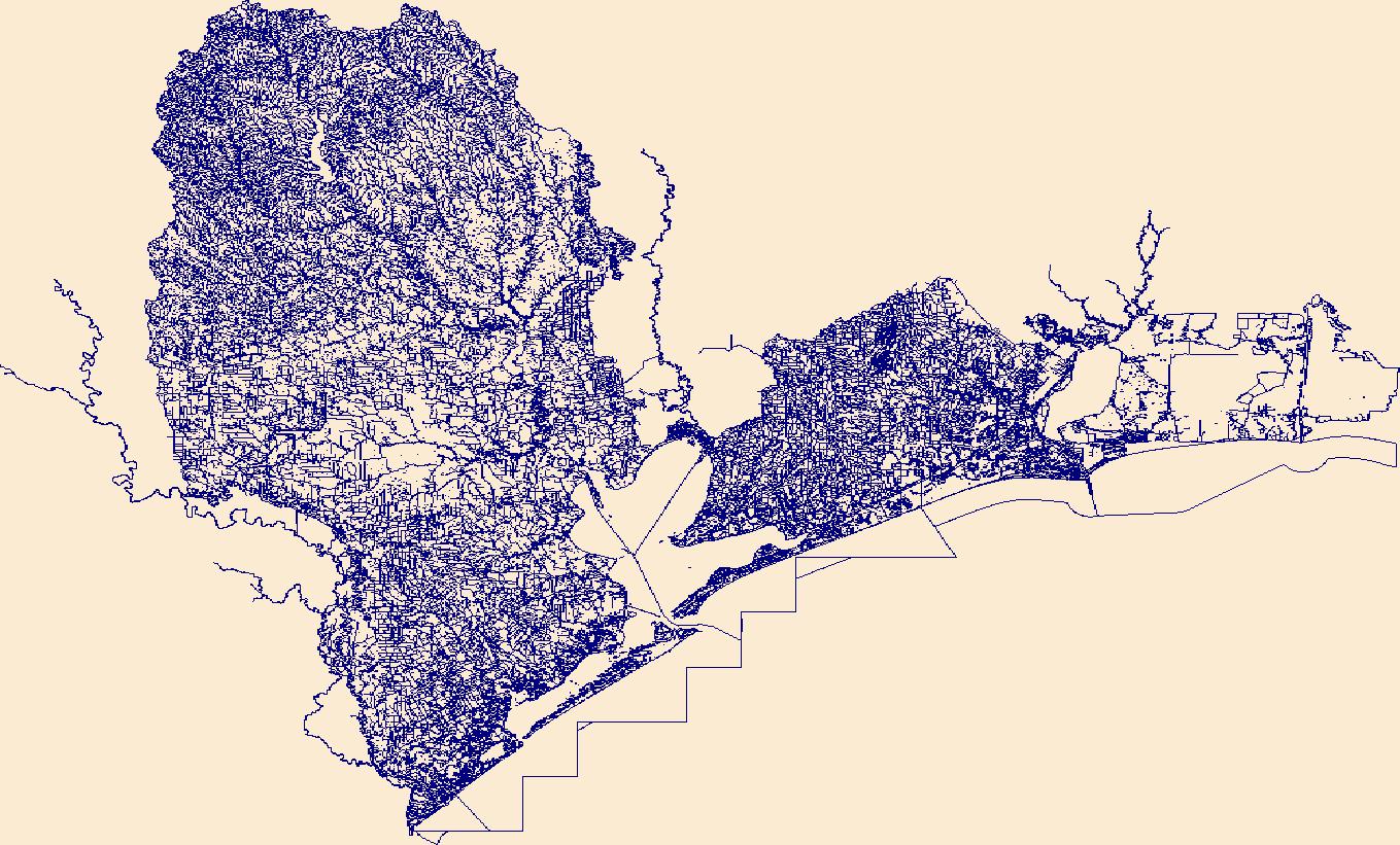
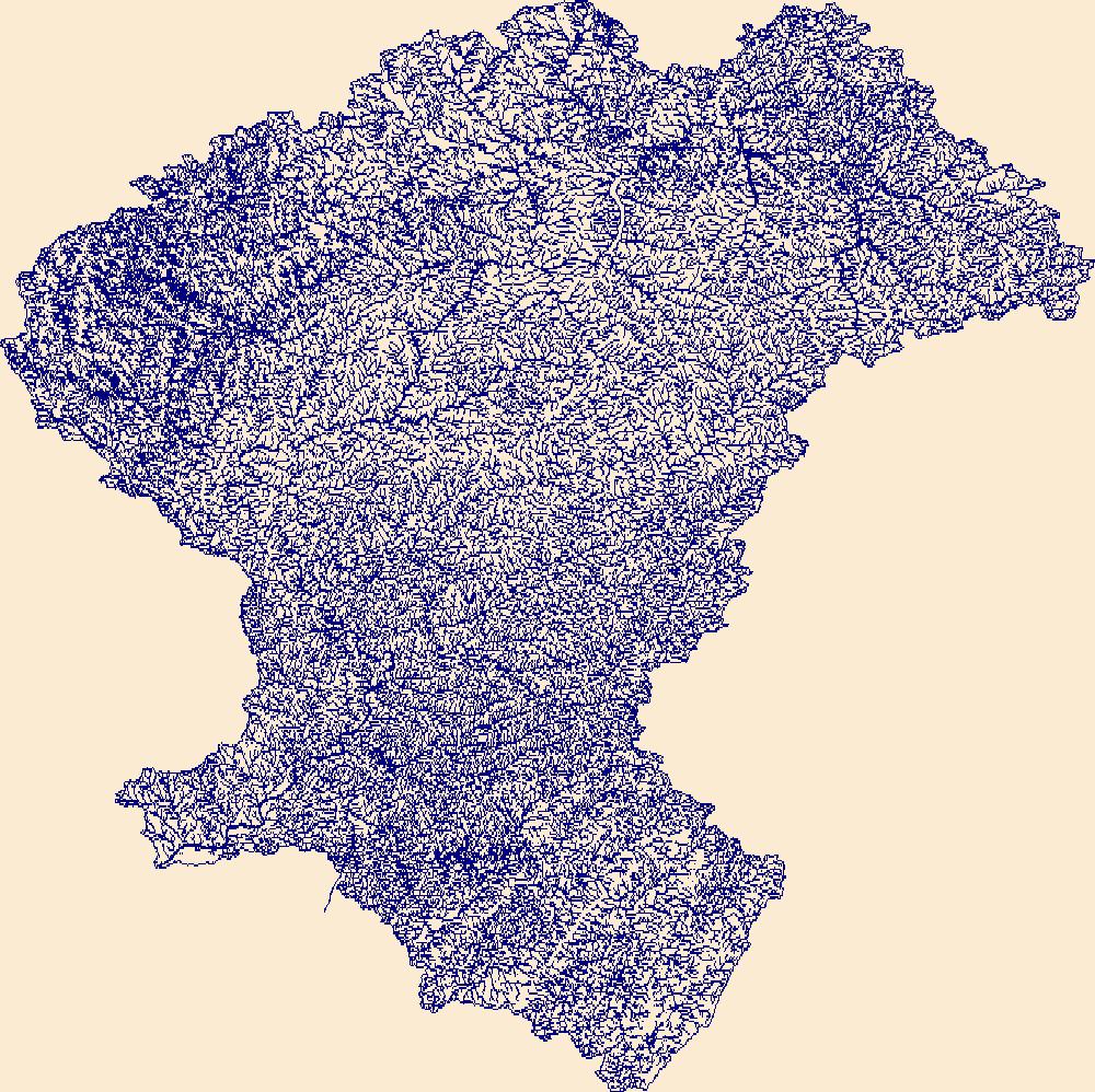
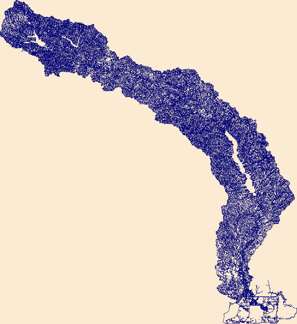
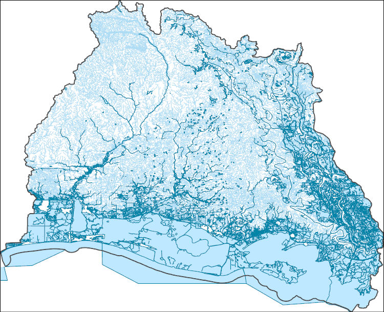
The High Resolution National Hydrography Dataset Plus (NHDPlus HR) is an integrated set of geospatial data layers, including the best available National Hydrography Dataset (NHD), the 10-meter 3D Elevation Program Digital Elevation Model (3DEP DEM), and the National Watershed Boundary Dataset (WBD). The NHDPlus HR combines the NHD, 3DEP DEMs, and WBD to create a stream network with linear referencing, feature naming, "value added attributes" (VAAs), elevation-derived catchments, and other features for hydrologic data analysis. The stream network with linear referencing is a system of data relationships applied to hydrographic systems so that one stream reach "flows" into another and "events" can be tied to and traced...
Tags: Cameron County,
Downloadable Data,
FileGDB,
FileGDB 10.1,
HU-4 Subregion, All tags...
HU-4 Subregion,
HU4_1309,
Hidalgo County,
Hydrography,
Jim Hogg County,
NHDPlus HR Rasters,
NHDPlus High Resolution (NHDPlus HR),
National Hydrography Dataset (NHD),
National Hydrography Dataset Plus High Resolution (NHDPlus HR),
National Hydrography Dataset Plus High Resolution (NHDPlus HR) Current,
Starr County,
TX,
Texas,
US,
United States,
Zapata County,
base maps,
cartography,
catchments,
channels,
digital elevation models,
drainage basins,
earth sciences,
elevation,
environment,
geographic information systems,
geoscientific,
geospatial analysis,
hydrographic datasets,
hydrographic features,
hydrology,
imagery,
inland waters,
lakes,
land surface characteristics,
reservoirs,
river reaches,
rivers,
streamflow,
streamflow data,
streams,
topography,
water bodies,
water quality,
water resources,
watersheds, Fewer tags
The High Resolution National Hydrography Dataset Plus (NHDPlus HR) is an integrated set of geospatial data layers, including the best available National Hydrography Dataset (NHD), the 10-meter 3D Elevation Program Digital Elevation Model (3DEP DEM), and the National Watershed Boundary Dataset (WBD). The NHDPlus HR combines the NHD, 3DEP DEMs, and WBD to create a stream network with linear referencing, feature naming, "value added attributes" (VAAs), elevation-derived catchments, and other features for hydrologic data analysis. The stream network with linear referencing is a system of data relationships applied to hydrographic systems so that one stream reach "flows" into another and "events" can be tied to and traced...
Tags: Brazoria County,
Cameron County,
Chambers County,
Downloadable Data,
FileGDB, All tags...
FileGDB 10.1,
Fort Bend County,
Galveston County,
Grimes County,
HU-4 Subregion,
HU-4 Subregion,
HU4_1204,
Harris County,
Hydrography,
Jefferson County,
LA,
Liberty County,
Louisiana,
Montgomery County,
NHDPlus HR Rasters,
NHDPlus High Resolution (NHDPlus HR),
National Hydrography Dataset (NHD),
National Hydrography Dataset Plus High Resolution (NHDPlus HR),
National Hydrography Dataset Plus High Resolution (NHDPlus HR) Current,
Orange County,
San Jacinto County,
TX,
Texas,
US,
United States,
Walker County,
Waller County,
base maps,
cartography,
catchments,
channels,
digital elevation models,
drainage basins,
earth sciences,
elevation,
environment,
geographic information systems,
geoscientific,
geospatial analysis,
hydrographic datasets,
hydrographic features,
hydrology,
imagery,
inland waters,
lakes,
land surface characteristics,
reservoirs,
river reaches,
rivers,
streamflow,
streamflow data,
streams,
topography,
water bodies,
water quality,
water resources,
watersheds, Fewer tags
The High Resolution National Hydrography Dataset Plus (NHDPlus HR) is an integrated set of geospatial data layers, including the best available National Hydrography Dataset (NHD), the 10-meter 3D Elevation Program Digital Elevation Model (3DEP DEM), and the National Watershed Boundary Dataset (WBD). The NHDPlus HR combines the NHD, 3DEP DEMs, and WBD to create a stream network with linear referencing, feature naming, "value added attributes" (VAAs), elevation-derived catchments, and other features for hydrologic data analysis. The stream network with linear referencing is a system of data relationships applied to hydrographic systems so that one stream reach "flows" into another and "events" can be tied to and traced...
Tags: Allegany County,
Allegheny County,
Armstrong County,
Bedford County,
Blair County, All tags...
Butler County,
Cambria County,
Cameron County,
Cattaraugus County,
Chautauqua County,
Clarion County,
Clearfield County,
Crawford County,
Downloadable Data,
Elk County,
Erie County,
FileGDB,
FileGDB 10.1,
Forest County,
HU-4 Subregion,
HU-4 Subregion,
HU4_0501,
Hydrography,
Indiana County,
Jefferson County,
McKean County,
Mercer County,
NHDPlus HR Rasters,
NHDPlus High Resolution (NHDPlus HR),
NY,
National Hydrography Dataset (NHD),
National Hydrography Dataset Plus High Resolution (NHDPlus HR),
National Hydrography Dataset Plus High Resolution (NHDPlus HR) Current,
New York,
PA,
Pennsylvania,
Potter County,
Somerset County,
US,
United States,
Venango County,
Warren County,
Westmoreland County,
base maps,
cartography,
catchments,
channels,
digital elevation models,
drainage basins,
earth sciences,
elevation,
environment,
geographic information systems,
geoscientific,
geospatial analysis,
hydrographic datasets,
hydrographic features,
hydrology,
imagery,
inland waters,
lakes,
land surface characteristics,
reservoirs,
river reaches,
rivers,
streamflow,
streamflow data,
streams,
topography,
water bodies,
water quality,
water resources,
watersheds, Fewer tags
The High Resolution National Hydrography Dataset Plus (NHDPlus HR) is an integrated set of geospatial data layers, including the best available National Hydrography Dataset (NHD), the 10-meter 3D Elevation Program Digital Elevation Model (3DEP DEM), and the National Watershed Boundary Dataset (WBD). The NHDPlus HR combines the NHD, 3DEP DEMs, and WBD to create a stream network with linear referencing, feature naming, "value added attributes" (VAAs), elevation-derived catchments, and other features for hydrologic data analysis. The stream network with linear referencing is a system of data relationships applied to hydrographic systems so that one stream reach "flows" into another and "events" can be tied to and traced...
Tags: Beauregard County,
Caddo County,
Calcasieu County,
Cameron County,
Collin County, All tags...
De Soto County,
Downloadable Data,
FileGDB,
FileGDB 10.1,
Franklin County,
Gregg County,
HU-4 Subregion,
HU-4 Subregion,
HU4_1201,
Harrison County,
Hopkins County,
Hunt County,
Hydrography,
Jasper County,
Kaufman County,
LA,
Louisiana,
NHDPlus HR Rasters,
NHDPlus High Resolution (NHDPlus HR),
Natchitoches County,
National Hydrography Dataset (NHD),
National Hydrography Dataset Plus High Resolution (NHDPlus HR),
National Hydrography Dataset Plus High Resolution (NHDPlus HR) Current,
Newton County,
Orange County,
Panola County,
Rains County,
Rockwall County,
Rusk County,
Sabine County,
Sabine County,
San Augustine County,
Shelby County,
Smith County,
TX,
Texas,
US,
United States,
Upshur County,
Van Zandt County,
Vernon County,
Wood County,
base maps,
cartography,
catchments,
channels,
digital elevation models,
drainage basins,
earth sciences,
elevation,
environment,
geographic information systems,
geoscientific,
geospatial analysis,
hydrographic datasets,
hydrographic features,
hydrology,
imagery,
inland waters,
lakes,
land surface characteristics,
reservoirs,
river reaches,
rivers,
streamflow,
streamflow data,
streams,
topography,
water bodies,
water quality,
water resources,
watersheds, Fewer tags
The High Resolution National Hydrography Dataset Plus (NHDPlus HR) is an integrated set of geospatial data layers, including the best available National Hydrography Dataset (NHD), the 10-meter 3D Elevation Program Digital Elevation Model (3DEP DEM), and the National Watershed Boundary Dataset (WBD). The NHDPlus HR combines the NHD, 3DEP DEMs, and WBD to create a stream network with linear referencing, feature naming, "value added attributes" (VAAs), elevation-derived catchments, and other features for hydrologic data analysis. The stream network with linear referencing is a system of data relationships applied to hydrographic systems so that one stream reach "flows" into another and "events" can be tied to and traced...
Tags: Acadia County,
Allen County,
Avoyelles County,
Beauregard County,
Calcasieu County, All tags...
Cameron County,
Downloadable Data,
Evangeline County,
FileGDB,
FileGDB 10.1,
HU-4 Subregion,
HU-4 Subregion,
HU4_0808,
Hydrography,
Iberia County,
Iberville County,
Jefferson Davis County,
LA,
Lafayette County,
Louisiana,
NHDPlus HR Rasters,
NHDPlus High Resolution (NHDPlus HR),
Natchitoches County,
National Hydrography Dataset (NHD),
National Hydrography Dataset Plus High Resolution (NHDPlus HR),
National Hydrography Dataset Plus High Resolution (NHDPlus HR) Current,
Pointe Coupee County,
Rapides County,
St. Landry County,
St. Martin County,
St. Mary County,
Terrebonne County,
US,
United States,
Vermilion County,
Vernon County,
base maps,
cartography,
catchments,
channels,
digital elevation models,
drainage basins,
earth sciences,
elevation,
environment,
geographic information systems,
geoscientific,
geospatial analysis,
hydrographic datasets,
hydrographic features,
hydrology,
imagery,
inland waters,
lakes,
land surface characteristics,
reservoirs,
river reaches,
rivers,
streamflow,
streamflow data,
streams,
topography,
water bodies,
water quality,
water resources,
watersheds, Fewer tags
The High Resolution National Hydrography Dataset Plus (NHDPlus HR) is an integrated set of geospatial data layers, including the best available National Hydrography Dataset (NHD), the 10-meter 3D Elevation Program Digital Elevation Model (3DEP DEM), and the National Watershed Boundary Dataset (WBD). The NHDPlus HR combines the NHD, 3DEP DEMs, and WBD to create a stream network with linear referencing, feature naming, "value added attributes" (VAAs), elevation-derived catchments, and other features for hydrologic data analysis. The stream network with linear referencing is a system of data relationships applied to hydrographic systems so that one stream reach "flows" into another and "events" can be tied to and traced...
Tags: Aransas County,
Atascosa County,
Bandera County,
Bee County,
Bexar County, All tags...
Brooks County,
Cameron County,
Dimmit County,
Downloadable Data,
Duval County,
Edwards County,
FileGDB,
FileGDB 10.1,
Frio County,
HU-4 Subregion,
HU-4 Subregion,
HU4_1211,
Hidalgo County,
Hydrography,
Jim Hogg County,
Jim Wells County,
Karnes County,
Kenedy County,
Kerr County,
Kinney County,
Kleberg County,
La Salle County,
Live Oak County,
Maverick County,
McMullen County,
Medina County,
NHDPlus HR Rasters,
NHDPlus High Resolution (NHDPlus HR),
National Hydrography Dataset (NHD),
National Hydrography Dataset Plus High Resolution (NHDPlus HR),
National Hydrography Dataset Plus High Resolution (NHDPlus HR) Current,
Nueces County,
Real County,
San Patricio County,
Starr County,
TX,
Texas,
US,
United States,
Uvalde County,
Webb County,
Willacy County,
Wilson County,
Zavala County,
base maps,
cartography,
catchments,
channels,
digital elevation models,
drainage basins,
earth sciences,
elevation,
environment,
geographic information systems,
geoscientific,
geospatial analysis,
hydrographic datasets,
hydrographic features,
hydrology,
imagery,
inland waters,
lakes,
land surface characteristics,
reservoirs,
river reaches,
rivers,
streamflow,
streamflow data,
streams,
topography,
water bodies,
water quality,
water resources,
watersheds, Fewer tags

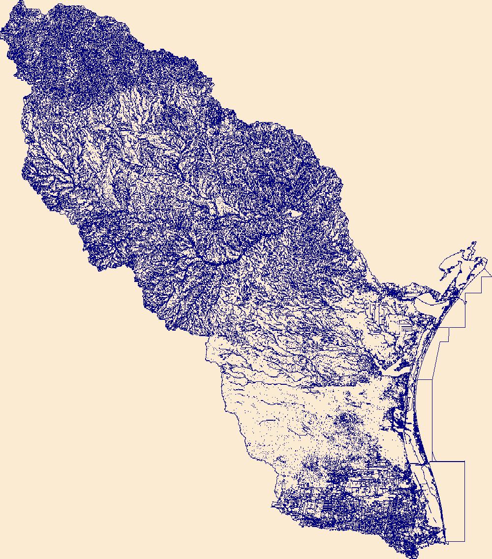
The High Resolution National Hydrography Dataset Plus (NHDPlus HR) is an integrated set of geospatial data layers, including the National Hydrography Dataset (NHD), National Watershed Boundary Dataset (WBD), and 3D Elevation Program Digital Elevation Model (3DEP DEM). The NHDPlus HR combines the NHD, 3DEP DEMs, and WBD to a data suite that includes the NHD stream network with linear referencing functionality, the WBD hydrologic units, elevation-derived catchment areas for each stream segment, "value added attributes" (VAAs), and other features that enhance hydrologic data analysis and routing.
Tags: 4-digit hydrologic unit,
Adams County,
Allegany County,
Baltimore County,
Bedford County, All tags...
Berks County,
Blair County,
Bradford County,
Broome County,
Cambria County,
Cameron County,
Carbon County,
Carroll County,
Cecil County,
Centre County,
Chemung County,
Chenango County,
Chester County,
Clearfield County,
Clinton County,
Columbia County,
Cortland County,
Cumberland County,
Dauphin County,
Delaware County,
Downloadable Data,
Elk County,
FileGDB,
Franklin County,
Fulton County,
HU-4 Subregion,
HU4,
HU4_0205,
Harford County,
Herkimer County,
Huntingdon County,
Hydrography,
Indiana County,
Jefferson County,
Juniata County,
Lackawanna County,
Lancaster County,
Lebanon County,
Livingston County,
Luzerne County,
Lycoming County,
MD,
Madison County,
Maryland,
McKean County,
Mifflin County,
Montgomery County,
Montour County,
NHDPlus HR Rasters,
NHDPlus High Resolution (NHDPlus HR),
NY,
National Hydrography Dataset (NHD),
National Hydrography Dataset Plus High Resolution (NHDPlus HR),
National Hydrography Dataset Plus High Resolution (NHDPlus HR) Current,
New York,
Northumberland County,
Oneida County,
Onondaga County,
Ontario County,
Otsego County,
PA,
Pennsylvania,
Perry County,
Potter County,
Schoharie County,
Schuyler County,
Schuylkill County,
Snyder County,
Somerset County,
Steuben County,
Sullivan County,
Susquehanna County,
Tioga County,
Tompkins County,
US,
Union County,
United States,
Wayne County,
Wyoming County,
Yates County,
York County,
base maps,
cartography,
catchments,
channels,
digital elevation models,
drainage basins,
earthsciences,
environment,
geographic information systems,
geoscientificInformation,
geospatial analysis,
hydrographic datasets,
hydrographic features,
hydrology,
inlandWaters,
lakes,
land surface characteristics,
reservoirs,
river reaches,
rivers,
streamflow,
streamflow data,
streams,
surface water quality,
topography,
water resources,
waterbodies,
watersheds, Fewer tags
|
|

