Filters
Date Types (for Date Range)
Contacts
Tag Types
Tag Schemes
|

The High Resolution National Hydrography Dataset Plus (NHDPlus HR) is an integrated set of geospatial data layers, including the best available National Hydrography Dataset (NHD), the 10-meter 3D Elevation Program Digital Elevation Model (3DEP DEM), and the National Watershed Boundary Dataset (WBD). The NHDPlus HR combines the NHD, 3DEP DEMs, and WBD to create a stream network with linear referencing, feature naming, "value added attributes" (VAAs), elevation-derived catchments, and other features for hydrologic data analysis. The stream network with linear referencing is a system of data relationships applied to hydrographic systems so that one stream reach "flows" into another and "events" can be tied to and traced...
Tags: Atoka County,
Blaine County,
Caddo County,
Canadian County,
Carson County, All tags...
Cimarron County,
Cleveland County,
Colfax County,
Curry County,
Custer County,
Dallam County,
Deaf Smith County,
Dewey County,
Downloadable Data,
Ellis County,
FileGDB,
FileGDB 10.1,
Garvin County,
Grady County,
Gray County,
HU-4 Subregion,
HU-4 Subregion,
HU4_1109,
Hansford County,
Harding County,
Hartley County,
Haskell County,
Hemphill County,
Hughes County,
Hutchinson County,
Hydrography,
Latimer County,
Lipscomb County,
McClain County,
McIntosh County,
Moore County,
Muskogee County,
NHDPlus HR Rasters,
NHDPlus High Resolution (NHDPlus HR),
NM,
National Hydrography Dataset (NHD),
National Hydrography Dataset Plus High Resolution (NHDPlus HR),
National Hydrography Dataset Plus High Resolution (NHDPlus HR) Current,
New Mexico,
OK,
Ochiltree County,
Oklahoma,
Oklahoma County,
Oldham County,
Pittsburg County,
Pontotoc County,
Pottawatomie County,
Potter County,
Quay County,
Randall County,
Roberts County,
Roger Mills County,
Seminole County,
TX,
Texas,
US,
Union County,
United States,
Woodward County,
base maps,
cartography,
catchments,
channels,
digital elevation models,
drainage basins,
earth sciences,
elevation,
environment,
geographic information systems,
geoscientific,
geospatial analysis,
hydrographic datasets,
hydrographic features,
hydrology,
imagery,
inland waters,
lakes,
land surface characteristics,
reservoirs,
river reaches,
rivers,
streamflow,
streamflow data,
streams,
topography,
water bodies,
water quality,
water resources,
watersheds, Fewer tags

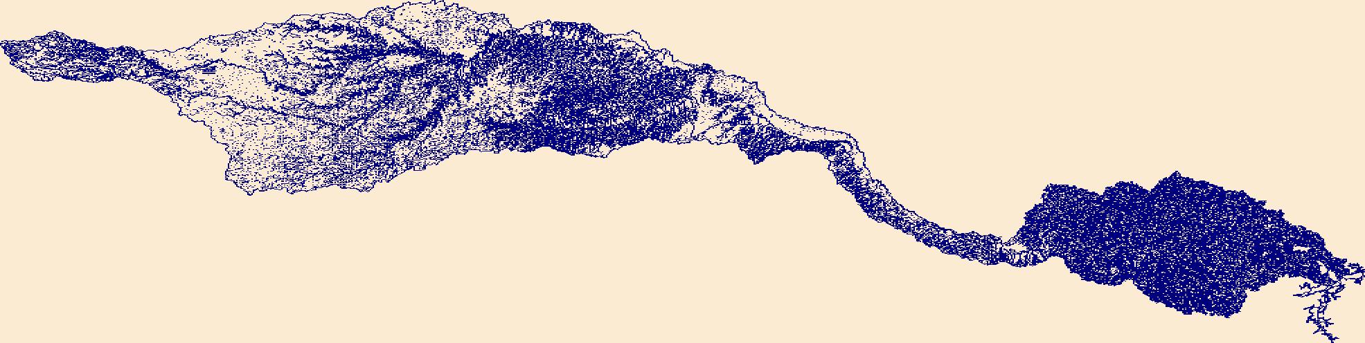
The High Resolution National Hydrography Dataset Plus (NHDPlus HR) is an integrated set of geospatial data layers, including the best available National Hydrography Dataset (NHD), the 10-meter 3D Elevation Program Digital Elevation Model (3DEP DEM), and the National Watershed Boundary Dataset (WBD). The NHDPlus HR combines the NHD, 3DEP DEMs, and WBD to create a stream network with linear referencing, feature naming, "value added attributes" (VAAs), elevation-derived catchments, and other features for hydrologic data analysis. The stream network with linear referencing is a system of data relationships applied to hydrographic systems so that one stream reach "flows" into another and "events" can be tied to and traced...
Tags: Abbeville County,
Aiken County,
Alexander County,
Allendale County,
Anderson County, All tags...
Avery County,
Bamberg County,
Barnwell County,
Beaufort County,
Berkeley County,
Buncombe County,
Burke County,
Caldwell County,
Calhoun County,
Catawba County,
Charleston County,
Cherokee County,
Chester County,
Clarendon County,
Cleveland County,
Colleton County,
Dorchester County,
Downloadable Data,
Edgefield County,
Fairfield County,
FileGDB,
FileGDB 10.1,
Gaston County,
Georgetown County,
Greenville County,
Greenwood County,
HU-4 Subregion,
HU-4 Subregion,
HU4_0305,
Hampton County,
Henderson County,
Hydrography,
Iredell County,
Jasper County,
Kershaw County,
Lancaster County,
Laurens County,
Lee County,
Lexington County,
Lincoln County,
McDowell County,
Mecklenburg County,
Mitchell County,
NC,
NHDPlus HR Rasters,
NHDPlus High Resolution (NHDPlus HR),
National Hydrography Dataset (NHD),
National Hydrography Dataset Plus High Resolution (NHDPlus HR),
National Hydrography Dataset Plus High Resolution (NHDPlus HR) Current,
Newberry County,
North Carolina,
Orangeburg County,
Pickens County,
Polk County,
Richland County,
Rutherford County,
SC,
Saluda County,
South Carolina,
Spartanburg County,
Sumter County,
Transylvania County,
US,
Union County,
Union County,
United States,
Watauga County,
Wilkes County,
Williamsburg County,
Yancey County,
York County,
base maps,
cartography,
catchments,
channels,
digital elevation models,
drainage basins,
earth sciences,
elevation,
environment,
geographic information systems,
geoscientific,
geospatial analysis,
hydrographic datasets,
hydrographic features,
hydrology,
imagery,
inland waters,
lakes,
land surface characteristics,
reservoirs,
river reaches,
rivers,
streamflow,
streamflow data,
streams,
topography,
water bodies,
water quality,
water resources,
watersheds, Fewer tags
The High Resolution National Hydrography Dataset Plus (NHDPlus HR) is an integrated set of geospatial data layers, including the best available National Hydrography Dataset (NHD), the 10-meter 3D Elevation Program Digital Elevation Model (3DEP DEM), and the National Watershed Boundary Dataset (WBD). The NHDPlus HR combines the NHD, 3DEP DEMs, and WBD to create a stream network with linear referencing, feature naming, "value added attributes" (VAAs), elevation-derived catchments, and other features for hydrologic data analysis. The stream network with linear referencing is a system of data relationships applied to hydrographic systems so that one stream reach "flows" into another and "events" can be tied to and traced...
Tags: Beaver County,
Blaine County,
Canadian County,
Cimarron County,
Cleveland County, All tags...
Creek County,
Dallam County,
Dewey County,
Downloadable Data,
Ellis County,
FileGDB,
FileGDB 10.1,
HU-4 Subregion,
HU-4 Subregion,
HU4_1110,
Hansford County,
Harper County,
Hartley County,
Hemphill County,
Hughes County,
Hutchinson County,
Hydrography,
KS,
Kansas,
Lincoln County,
Lipscomb County,
Logan County,
Major County,
McIntosh County,
Moore County,
Muskogee County,
NHDPlus HR Rasters,
NHDPlus High Resolution (NHDPlus HR),
NM,
National Hydrography Dataset (NHD),
National Hydrography Dataset Plus High Resolution (NHDPlus HR),
National Hydrography Dataset Plus High Resolution (NHDPlus HR) Current,
New Mexico,
OK,
Ochiltree County,
Okfuskee County,
Oklahoma,
Oklahoma County,
Okmulgee County,
Pottawatomie County,
Seminole County,
Seward County,
Sherman County,
Stevens County,
TX,
Texas,
Texas County,
US,
Union County,
United States,
Woodward County,
base maps,
cartography,
catchments,
channels,
digital elevation models,
drainage basins,
earth sciences,
elevation,
environment,
geographic information systems,
geoscientific,
geospatial analysis,
hydrographic datasets,
hydrographic features,
hydrology,
imagery,
inland waters,
lakes,
land surface characteristics,
reservoirs,
river reaches,
rivers,
streamflow,
streamflow data,
streams,
topography,
water bodies,
water quality,
water resources,
watersheds, Fewer tags
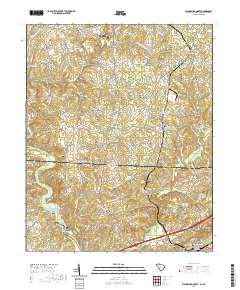
Layered geospatial PDF 7.5 Minute Quadrangle Map. Layers of geospatial data include orthoimagery, roads, grids, geographic names, elevation contours, hydrography, and other selected map features. This map is derived from GIS (geospatial information system) data. It represents a repackaging of GIS data in traditional map form, not creation of new information. The geospatial data in this map are from selected National Map data holdings and other government sources.
Tags: 7.5 x 7.5 minute,
Blacksburg North, SC,NC,
Cherokee County,
Cleveland County,
Downloadable Data, All tags...
EarthCover,
Geospatial PDF,
Imagery and Base Maps,
Map,
Public Land Survey System,
South Carolina,
U.S. National Grid,
US,
US Topo,
US Topo Historical,
boundary,
contour,
geographic names,
hydrography,
imageryBaseMapsEarthCover,
orthoimage,
structures,
topographic,
transportation,
woodland, Fewer tags
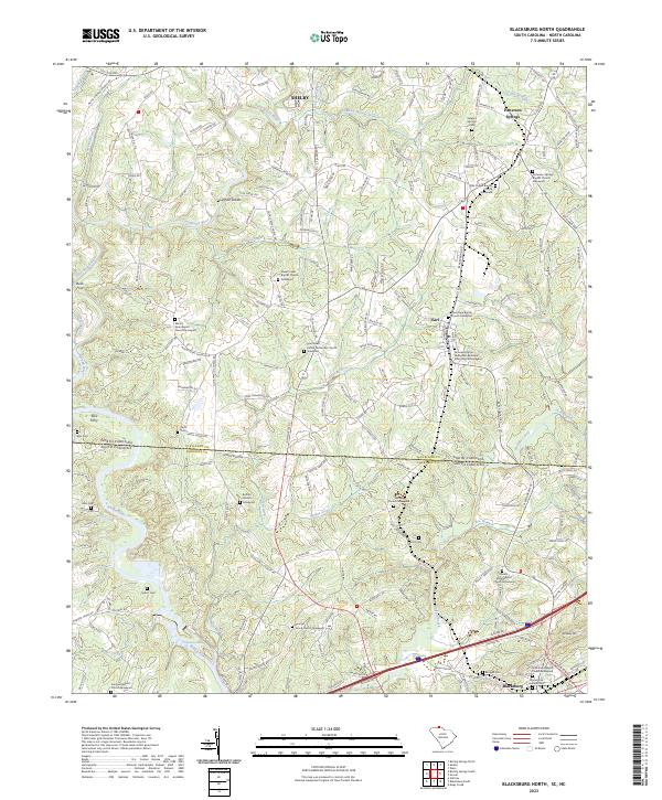
Layered geospatial PDF 7.5 Minute Quadrangle Map. Layers of geospatial data include orthoimagery, roads, grids, geographic names, elevation contours, hydrography, and other selected map features. This map is derived from GIS (geospatial information system) data. It represents a repackaging of GIS data in traditional map form, not creation of new information. The geospatial data in this map are from selected National Map data holdings and other government sources.
Tags: 7.5 x 7.5 minute,
Cherokee County,
Cleveland County,
Downloadable Data,
EarthCover, All tags...
Geospatial PDF,
Imagery and Base Maps,
Map,
Public Land Survey System,
South Carolina,
U.S. National Grid,
US,
US Topo,
US Topo Current,
boundary,
contour,
geographic names,
hydrography,
imageryBaseMapsEarthCover,
orthoimage,
structures,
topographic,
transportation,
woodland, Fewer tags

The High Resolution National Hydrography Dataset Plus (NHDPlus HR) is an integrated set of geospatial data layers, including the best available National Hydrography Dataset (NHD), the 10-meter 3D Elevation Program Digital Elevation Model (3DEP DEM), and the National Watershed Boundary Dataset (WBD). The NHDPlus HR combines the NHD, 3DEP DEMs, and WBD to create a stream network with linear referencing, feature naming, "value added attributes" (VAAs), elevation-derived catchments, and other features for hydrologic data analysis. The stream network with linear referencing is a system of data relationships applied to hydrographic systems so that one stream reach "flows" into another and "events" can be tied to and traced...
Tags: AR,
Arkansas,
Ashley County,
Avoyelles County,
Bienville County, All tags...
Bradley County,
Caldwell County,
Calhoun County,
Catahoula County,
Chicot County,
Claiborne County,
Clark County,
Cleveland County,
Columbia County,
Concordia County,
Dallas County,
Desha County,
Downloadable Data,
Drew County,
FileGDB,
FileGDB 10.1,
Garland County,
Grant County,
Grant County,
HU-4 Subregion,
HU-4 Subregion,
HU4_0804,
Hempstead County,
Hot Spring County,
Howard County,
Hydrography,
Jackson County,
Jefferson County,
LA,
LaSalle County,
Lincoln County,
Lincoln County,
Louisiana,
Montgomery County,
Morehouse County,
NHDPlus HR Rasters,
NHDPlus High Resolution (NHDPlus HR),
National Hydrography Dataset (NHD),
National Hydrography Dataset Plus High Resolution (NHDPlus HR),
National Hydrography Dataset Plus High Resolution (NHDPlus HR) Current,
Nevada County,
Ouachita County,
Ouachita County,
Perry County,
Pike County,
Pointe Coupee County,
Polk County,
Pulaski County,
Rapides County,
Saline County,
Scott County,
Tensas County,
US,
Union County,
Union County,
United States,
West Feliciana County,
Winn County,
Yell County,
base maps,
cartography,
catchments,
channels,
digital elevation models,
drainage basins,
earth sciences,
elevation,
environment,
geographic information systems,
geoscientific,
geospatial analysis,
hydrographic datasets,
hydrographic features,
hydrology,
imagery,
inland waters,
lakes,
land surface characteristics,
reservoirs,
river reaches,
rivers,
streamflow,
streamflow data,
streams,
topography,
water bodies,
water quality,
water resources,
watersheds, Fewer tags
|
|

