Filters: Tags: Conservation easement (X)
114 results (20ms)|
Filters
Date Range
Extensions (Less) Types (Less)
Contacts (Less)
Categories (Less) Tag Types
|

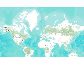
Protected areas are cornerstones of national and international conservation strategies. By way of these designations, lands and waters are set-aside in-perpetuity to preserve functioning natural ecosystems, act as refuges for species, and maintain ecological processes. Complementary conservation strategies preserve land for the sustainable use of natural resources, or for the protection of significant geologic and cultural features or open space. PAD-US 1.1 (CBI Edition) attempts to include all available spatial data on these places. It is our goal to publish the most comprehensive geospatial data set of U. S. protected areas to date. PAD-US 1.1 (CBI Edition) is limited to the continental U.S., Alaska, and Hawaii....

Protected areas are cornerstones of national and international conservation strategies. By way of these designations, lands and waters are set-aside in-perpetuity to preserve functioning natural ecosystems, act as refuges for species, and maintain ecological processes. Complementary conservation strategies preserve land for the sustainable use of natural resources, or for the protection of significant geologic and cultural features or open space. PAD-US 1.1 (CBI Edition) attempts to include all available spatial data on these places. It is our goal to publish the most comprehensive geospatial data set of U. S. protected areas to date. PAD-US 1.1 (CBI Edition) is limited to the continental U.S., Alaska, and Hawaii....
This dataset is an extraction from PAD-US 1.1 (CBI Edition), by National Parks management designation. The PAD-US 1.1 (CBI Edition) data set portrays the nation's protected areas with a standardized spatial geometry and numerous valuable attributes on land ownership, management designations, and conservation status (using national GAP and international IUCN coding systems). The PAD-US 1.1 (CBI Edition) defines protected areas to include all lands dedicated to the preservation of biological diversity and to other natural, recreation and cultural uses, and managed for these purposes through legal or other effective means (adapted from IUCN definition). The database represents the full range of conservation designations...
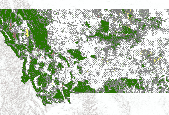
(A newer version of these data is now available, Protected Areas - Montana, October 2012 ) This dataset is an extraction from PAD-US 1.1 (CBI Edition), by state. The PAD-US 1.1 (CBI Edition) data set portrays the nation's protected areas with a standardized spatial geometry and numerous valuable attributes on land ownership, management designations, and conservation status (using national GAP and international IUCN coding systems). The PAD-US 1.1 (CBI Edition) defines protected areas to include all lands dedicated to the preservation of biological diversity and to other natural, recreation and cultural uses, and managed for these purposes through legal or other effective means (adapted from IUCN definition). The...
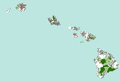
(A newer version of these data is now available, Protected Areas - Hawaii, October 2012 ) This dataset is an extraction from PAD-US 1.1 (CBI Edition), by state. The PAD-US 1.1 (CBI Edition) data set portrays the nation's protected areas with a standardized spatial geometry and numerous valuable attributes on land ownership, management designations, and conservation status (using national GAP and international IUCN coding systems). The PAD-US 1.1 (CBI Edition) defines protected areas to include all lands dedicated to the preservation of biological diversity and to other natural, recreation and cultural uses, and managed for these purposes through legal or other effective means (adapted from IUCN definition). The...

This dataset is extracted from PAD-US 1.1 (CBI Edition), and the original metadata has been included here, below. These protected areas were roughly identified by the Conservation Biology Institute as being secondarily threatened by the Deepwater Horizon oil spill in the Gulf of Mexico. The probability of being affected was determined using the University of South Florida's Deepwater Horizon oil spill trajectory forecast from the WFS ROMS numerical model, as projected for 06/11/2010 at 00h UTC (http://ocg6.marine.usf.edu/~liu/oil_spill_ensemble_forecast.html). For more information, please see the Oil Spill in the Gulf of Mexico page at Data Basin (http://www.databasin.org/aquatic-center/features/oil-spill or http://www.databasin.org)....

(A newer version of these data is now available, Protected Areas - Minnesota, October 2012 ) This dataset is an extraction from PAD-US 1.1 (CBI Edition), by state. The PAD-US 1.1 (CBI Edition) data set portrays the nation's protected areas with a standardized spatial geometry and numerous valuable attributes on land ownership, management designations, and conservation status (using national GAP and international IUCN coding systems). The PAD-US 1.1 (CBI Edition) defines protected areas to include all lands dedicated to the preservation of biological diversity and to other natural, recreation and cultural uses, and managed for these purposes through legal or other effective means (adapted from IUCN definition)....

(A newer version of these data is now available, Protected Areas - Maine, October 2012 ) This dataset is an extraction from PAD-US 1.1 (CBI Edition), by state. The PAD-US 1.1 (CBI Edition) data set portrays the nation's protected areas with a standardized spatial geometry and numerous valuable attributes on land ownership, management designations, and conservation status (using national GAP and international IUCN coding systems). The PAD-US 1.1 (CBI Edition) defines protected areas to include all lands dedicated to the preservation of biological diversity and to other natural, recreation and cultural uses, and managed for these purposes through legal or other effective means (adapted from IUCN definition). The...

This dataset is an extraction from PAD-US 1.1 (CBI Edition), by state. The PAD-US 1.1 (CBI Edition) data set portrays the nation's protected areas with a standardized spatial geometry and numerous valuable attributes on land ownership, management designations, and conservation status (using national GAP and international IUCN coding systems). The PAD-US 1.1 (CBI Edition) defines protected areas to include all lands dedicated to the preservation of biological diversity and to other natural, recreation and cultural uses, and managed for these purposes through legal or other effective means (adapted from IUCN definition). The database represents the full range of conservation designations that preserve these...
Protected areas are cornerstones of national and international conservation strategies. By way of these designations, lands and waters are set-aside in-perpetuity to preserve functioning natural ecosystems, act as refuges for species, and maintain ecological processes. Complementary conservation strategies preserve land for the sustainable use of natural resources, or for the protection of significant geologic and cultural features or open space. PAD-US 1.1 (CBI Edition) attempts to include all available spatial data on these places. It is our goal to publish the most comprehensive geospatial data set of U. S. protected areas to date. PAD-US 1.1 (CBI Edition) is limited to the continental U.S., Alaska, and Hawaii....
Background information.—Historically, the Powell River supported abundant and diverse populations of freshwater mussels. In recent decades, mussel density and species richness have declined and many freshwater mussel species are listed as either State or Federally threatened or endangered species. Environmental degradation from coal mining has been identified as one of the drivers of this decline. An example is the 1996 Lone Mountain slurry spill that directly affected mussel populations, as well as their host fish species. Freshwater mussels feed by filtering small particles from water, thereby improving water quality and providing an essential ecosystem service in rivers and streams. Mussels also serve as a food...
Categories: Project;
Types: Map Service,
OGC WFS Layer,
OGC WMS Layer,
OGC WMS Service;
Tags: Aquatic,
Aquatic species propagation,
Bank stabilization/erosion control,
Broadleaf,
Conservation easement,

(A newer version of these data is now available, Protected Areas - Arkansas, October 2012 ) This dataset is an extraction from PAD-US 1.1 (CBI Edition), by state. The PAD-US 1.1 (CBI Edition) data set portrays the nation's protected areas with a standardized spatial geometry and numerous valuable attributes on land ownership, management designations, and conservation status (using national GAP and international IUCN coding systems). The PAD-US 1.1 (CBI Edition) defines protected areas to include all lands dedicated to the preservation of biological diversity and to other natural, recreation and cultural uses, and managed for these purposes through legal or other effective means (adapted from IUCN definition). The...

(A newer version of these data is now available, Protected Areas - Florida, October 2012 ) The Florida Natural Areas Inventory (FNAI) is the primary source of protected areas data within the PAD-US 1.1 (CBI Edition) dataset for Florida. FNAI serves as Florida's central repository for conservation lands data and makes quarterly updates available on its web site. A shape file of the most current data on Florida conservation lands can be downloaded at: http://www.fnai.org/conservationlands.cfm. The PAD-US 1.1 (CBI Edition) utilizes the June 2009 version of FNAI data. This dataset is an extraction from PAD-US 1.1 (CBI Edition), by state. The PAD-US 1.1 (CBI Edition) data set portrays the nation's protected areas...

Protected areas are cornerstones of national and international conservation strategies. By way of these designations, lands and waters are set-aside in-perpetuity to preserve functioning natural ecosystems, act as refuges for species, and maintain ecological processes. Complementary conservation strategies preserve land for the sustainable use of natural resources, or for the protection of significant geologic and cultural features or open space. PAD-US 1.1 (CBI Edition) attempts to include all available spatial data on these places. It is our goal to publish the most comprehensive geospatial data set of U. S. protected areas to date. PAD-US 1.1 (CBI Edition) is limited to the continental U.S., Alaska, and Hawaii....
These protected areas were estimated by the Conservation Biology Institute as being secondarily threatened by the corresponding Deepwater Horizon oil spill trajectory forecast in the Gulf of Mexico. This dataset is extracted from PAD-US 1.1 (CBI Edition), and the original metadata has been included here, below. First, protected areas within 1 mile of the entire study area coastline (TX to NJ), or that intersect hydrological feature polygons from the NHDPlus National Hydrography Dataset within the 1-mile coastline buffer, were extracted from PAD-US 1.1 (CBI Edition). Then, protected areas were identified as being under primary, secondary, or tertiary threat from the oil spill. The probability of being affected...

This dataset is extracted from PAD-US 1.1 (CBI Edition), and the original metadata has been included here, below. These protected areas were roughly identified by the Conservation Biology Institute as being Secondarily threatened by the Deepwater Horizon oil spill in the Gulf of Mexico. The probability of being affected was determined using the University of South Florida's Deepwater Horizon oil spill trajectory forecast from the WFS ROMS numerical model, as projected for 06/11/2010 at 00h UTC (http://ocg6.marine.usf.edu/~liu/oil_spill_ensemble_forecast.html ). For more information, please see the Oil Spill in the Gulf of Mexico page at Data Basin (http://www.databasin.org/aquatic-center/features/oil-spill or...

This dataset is extracted from PAD-US 1.1 (CBI Edition), and the original metadata has been included here. These protected areas were roughly identified by the Conservation Biology Institute as being the "most immediately" threatened by the Deepwater Horizon oil spill in the Gulf of Mexico. The probability of being affected was determined using the University of South Florida's Deepwater Horizon oil spill trajectory forecast from the WFS ROMS numerical model, as projected for 06/03/2010 at 00h UTC (http://ocg6.marine.usf.edu/~liu/oil_spill_ensemble_forecast.html). For more information, please see the Oil Spill in the Gulf of Mexico page at Data Basin (http://www.databasin.org/aquatic-center/features/oil-spill...

(A newer version of these data is now available, Protected Areas - Oregon, October 2012 ) This dataset is an extraction from PAD-US 1.1 (CBI Edition), by state. The PAD-US 1.1 (CBI Edition) data set portrays the nation's protected areas with a standardized spatial geometry and numerous valuable attributes on land ownership, management designations, and conservation status (using national GAP and international IUCN coding systems). The PAD-US 1.1 (CBI Edition) defines protected areas to include all lands dedicated to the preservation of biological diversity and to other natural, recreation and cultural uses, and managed for these purposes through legal or other effective means (adapted from IUCN definition). The...

(A newer version of these data is now available, Protected Areas - Georgia, October 2012 ) This dataset is an extraction from PAD-US 1.1 (CBI Edition), by state. The PAD-US 1.1 (CBI Edition) data set portrays the nation's protected areas with a standardized spatial geometry and numerous valuable attributes on land ownership, management designations, and conservation status (using national GAP and international IUCN coding systems). The PAD-US 1.1 (CBI Edition) defines protected areas to include all lands dedicated to the preservation of biological diversity and to other natural, recreation and cultural uses, and managed for these purposes through legal or other effective means (adapted from IUCN definition). The...

(A newer version of these data is now available, Protected Areas - Connecticut, October 2012 ) This dataset is an extraction from PAD-US 1.1 (CBI Edition), by state. The PAD-US 1.1 (CBI Edition) data set portrays the nation's protected areas with a standardized spatial geometry and numerous valuable attributes on land ownership, management designations, and conservation status (using national GAP and international IUCN coding systems). The PAD-US 1.1 (CBI Edition) defines protected areas to include all lands dedicated to the preservation of biological diversity and to other natural, recreation and cultural uses, and managed for these purposes through legal or other effective means (adapted from IUCN definition)....
|

|
