Filters: Tags: Damage (X) > partyWithName: Conservation Biology Institute (X)
50 results (81ms)|
Filters
Date Range
Tag Schemes |

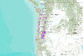
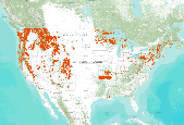
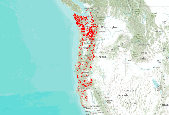
This dataset is a compilation of forest insect, disease and abiotic damage mapped by aerial detection surveys on forested areas in the United States. At this time, the National Aerial Survey Data Standards require only mortality and defoliation data be collected and reported. However, many cooperators collect data on other types of damage and therefore, the national database has been designed to accommodate these data. Low-level flights, typically 1,000 to 2,000 feet above ground level, are used to map forest damage. Observers use paper maps, typically 1:100,000 scale USGS maps, upon which they record the damage. There is also a digital sketchmap system that may be used. The digital system uses GPS to display the...

This dataset is a compilation of forest insect, disease and abiotic damage mapped by aerial detection surveys on forested areas in the United States. At this time, the National Aerial Survey Data Standards require only mortality and defoliation data be collected and reported. However, many cooperators collect data on other types of damage and therefore, the national database has been designed to accommodate these data. Low-level flights, typically 1,000 to 2,000 feet above ground level, are used to map forest damage. Observers use paper maps, typically 1:100,000 scale USGS maps, upon which they record the damage. There is also a digital sketchmap system that may be used. The digital system uses GPS to display the...
This dataset is a compilation of forest insect, disease and abiotic damage mapped by aerial detection surveys on forested areas in the United States. At this time, the National Aerial Survey Data Standards require only mortality and defoliation data be collected and reported. However, many cooperators collect data on other types of damage and therefore, the national database has been designed to accommodate these data. Low-level flights, typically 1,000 to 2,000 feet above ground level, are used to map forest damage. Observers use paper maps, typically 1:100,000 scale USGS maps, upon which they record the damage. There is also a digital sketchmap system that may be used. The digital system uses GPS to display the...
This dataset is a compilation of forest insect, disease and abiotic damage mapped by aerial detection surveys on forested areas in the United States. At this time, the National Aerial Survey Data Standards require only mortality and defoliation data be collected and reported. However, many cooperators collect data on other types of damage and therefore, the national database has been designed to accommodate these data. Low-level flights, typically 1,000 to 2,000 feet above ground level, are used to map forest damage. Observers use paper maps, typically 1:100,000 scale USGS maps, upon which they record the damage. There is also a digital sketchmap system that may be used. The digital system uses GPS to display the...

This dataset is a compilation of forest insect, disease and abiotic damage mapped by aerial detection surveys on forested areas in the United States. At this time, the National Aerial Survey Data Standards require only mortality and defoliation data be collected and reported. However, many cooperators collect data on other types of damage and therefore, the national database has been designed to accommodate these data. Low-level flights, typically 1,000 to 2,000 feet above ground level, are used to map forest damage. Observers use paper maps, typically 1:100,000 scale USGS maps, upon which they record the damage. There is also a digital sketchmap system that may be used. The digital system uses GPS to display the...

This data represents areas of forest damage due to insect infestation, fire, flood, landslides, windthrow and other mortalities. The information was collected by aerial surveys by both the USFS and ADNR, Div. of Forestry in cooperation with the Forest Health Protection (FHP) project. Surveys are conducted in July and August so that pest "signatures" may be obtained during the optimal period for symptom development of ocular estimation. The aerial survey is coordinated with known pest outbreaks so that the maximum extent of recent bark beetle damage (fading trees) and insect defoliation (discoloration, foliage loss) patterns may be determined. Aerial survey flights are termed as "local" if they can be completed...

This data represents areas of forest damage due to insect infestation, fire, flood, landslides, windthrow and other mortalities. The information was collected by aerial surveys by both the USFS and ADNR, Div. of Forestry in cooperation with the Forest Health Protection (FHP) project. Surveys are conducted in July and August so that pest "signatures" may be obtained during the optimal period for symptom development of ocular estimation. The aerial survey is coordinated with known pest outbreaks so that the maximum extent of recent bark beetle damage (fading trees) and insect defoliation (discoloration, foliage loss) patterns may be determined. Aerial survey flights are termed as "local" if they can be completed...
This dataset is a compilation of forest insect, disease and abiotic damage mapped by aerial detection surveys on forested areas in the United States. At this time, the National Aerial Survey Data Standards require only mortality and defoliation data be collected and reported. However, many cooperators collect data on other types of damage and therefore, the national database has been designed to accommodate these data. Low-level flights, typically 1,000 to 2,000 feet above ground level, are used to map forest damage. Observers use paper maps, typically 1:100,000 scale USGS maps, upon which they record the damage. There is also a digital sketchmap system that may be used. The digital system uses GPS to display the...

This data represents areas of forest damage due to insect infestation, fire, flood, landslides, windthrow and other mortalities. The information was collected by aerial surveys by both the USFS and ADNR, Div. of Forestry in cooperation with the Forest Health Protection (FHP) project. Surveys are conducted in July and August so that pest "signatures" may be obtained during the optimal period for symptom development of ocular estimation. The aerial survey is coordinated with known pest outbreaks so that the maximum extent of recent bark beetle damage (fading trees) and insect defoliation (discoloration, foliage loss) patterns may be determined. Aerial survey flights are termed as "local" if they can be completed...

This data represents areas of forest damage due to insect infestation, fire, flood, landslides, and windthrow. The information was collected by aerial surveys by both the USFS and ADNR, Div. of Forestry in cooperation with the Forest Health Protection (FHP) project. Surveys are conducted primarily in July and August so that pest signatures may be identified during the optimal period for symptom development of ocular estimation. The aerial survey is coordinated with known pest outbreaks so that the maximum extent of recent bark beetle damage (fading trees) and insect defoliation (discoloration, foliage loss) patterns may be determined. Aerial survey flights are termed as local if they can be completed within 1 day...

This dataset is a compilation of forest insect, disease and abiotic damage mapped by aerial detection surveys on forested areas in the United States. At this time, the National Aerial Survey Data Standards require only mortality and defoliation data be collected and reported. However, many cooperators collect data on other types of damage and therefore, the national database has been designed to accommodate these data. Low-level flights, typically 1,000 to 2,000 feet above ground level, are used to map forest damage. Observers use paper maps, typically 1:100,000 scale USGS maps, upon which they record the damage. There is also a digital sketchmap system that may be used. The digital system uses GPS to display the...

This dataset is a compilation of forest insect, disease and abiotic damage mapped by aerial detection surveys on forested areas in the United States. At this time, the National Aerial Survey Data Standards require only mortality and defoliation data be collected and reported. However, many cooperators collect data on other types of damage and therefore, the national database has been designed to accommodate these data. Low-level flights, typically 1,000 to 2,000 feet above ground level, are used to map forest damage. Observers use paper maps, typically 1:100,000 scale USGS maps, upon which they record the damage. There is also a digital sketchmap system that may be used. The digital system uses GPS to display the...

This data represents areas of forest damage due to insect infestation, fire, flood, landslides, windthrow and other mortalities. The information was collected by aerial surveys by both the USFS and ADNR, Div. of Forestry in cooperation with the Forest Health Protection (FHP) project. Surveys are conducted in July and August so that pest "signatures" may be obtained during the optimal period for symptom development of ocular estimation. The aerial survey is coordinated with known pest outbreaks so that the maximum extent of recent bark beetle damage (fading trees) and insect defoliation (discoloration, foliage loss) patterns may be determined. Aerial survey flights are termed as "local" if they can be completed...

This dataset is a compilation of forest insect, disease and abiotic damage mapped by aerial detection surveys on forested areas in the United States. At this time, the National Aerial Survey Data Standards require only mortality and defoliation data be collected and reported. However, many cooperators collect data on other types of damage and therefore, the national database has been designed to accommodate these data. Low-level flights, typically 1,000 to 2,000 feet above ground level, are used to map forest damage. Observers use paper maps, typically 1:100,000 scale USGS maps, upon which they record the damage. There is also a digital sketchmap system that may be used. The digital system uses GPS to display the...

This dataset is a compilation of forest insect, disease and abiotic damage mapped by aerial detection surveys on forested areas in the United States. At this time, the National Aerial Survey Data Standards require only mortality and defoliation data be collected and reported. However, many cooperators collect data on other types of damage and therefore, the national database has been designed to accommodate these data. Low-level flights, typically 1,000 to 2,000 feet above ground level, are used to map forest damage. Observers use paper maps, typically 1:100,000 scale USGS maps, upon which they record the damage. There is also a digital sketchmap system that may be used. The digital system uses GPS to display the...

This data represents areas of forest damage due to insect infestation, fire, flood, landslides, windthrow and other mortalities. The information was collected by aerial surveys by both the USFS and ADNR, Div. of Forestry in cooperation with the Forest Health Protection (FHP) project. Surveys are conducted in July and August so that pest "signatures" may be obtained during the optimal period for symptom development of ocular estimation. The aerial survey is coordinated with known pest outbreaks so that the maximum extent of recent bark beetle damage (fading trees) and insect defoliation (discoloration, foliage loss) patterns may be determined. Aerial survey flights are termed as "local" if they can be completed...

This data represents areas of forest damage due to insect infestation, fire, flood, landslides, and windthrow. The information was collected by aerial surveys by both the USFS and ADNR, Div. of Forestry in cooperation with the Forest Health Protection (FHP) project. Surveys are conducted primarily in July and August so that pest "signatures" may be identified during the optimal period for symptom development of ocular estimation. The aerial survey is coordinated with known pest outbreaks so that the maximum extent of recent bark beetle damage (fading trees) and insect defoliation (discoloration, foliage loss) patterns may be determined. Aerial survey flights are termed as "local" if they can be completed within...

This data represents areas of forest damage due to insect infestation, fire, flood, landslides, windthrow and other mortalities. The information was collected by aerial surveys by both the USFS and ADNR, Div. of Forestry in cooperation with the Forest Health Protection (FHP) project. Surveys are conducted in July and August so that pest "signatures" may be obtained during the optimal period for symptom development of ocular estimation. The aerial survey is coordinated with known pest outbreaks so that the maximum extent of recent bark beetle damage (fading trees) and insect defoliation (discoloration, foliage loss) patterns may be determined. Aerial survey flights are termed as "local" if they can be completed...
|

|
