Filters: Tags: Death Valley (X) > Date Range: {"choice":"year"} (X)
96 results (18ms)|
Filters
Date Types (for Date Range)
Categories Tag Types Tag Schemes |

These data were released prior to the October 1, 2016 effective date for the USGS’s policy dictating the review, approval, and release of scientific data as referenced in USGS Survey Manual Chapter 502.8 Fundamental Science Practices: Review and Approval of Scientific Data for Release. This digital data set defines the altitudes of the tops of 16 model layers simulated in the Death Valley regional ground-water flow system (DVRFS) transient flow model. The area simulated by the DVRFS transient ground-water flow model is an approximately 45,000 square-kilometer region of southern Nevada and California. The thickness of model layers is derived by sequentially subtracting the altitudes of the uppermost to the lowermost...

These data were released prior to the October 1, 2016 effective date for the USGS’s policy dictating the review, approval, and release of scientific data as referenced in USGS Survey Manual Chapter 502.8 Fundamental Science Practices: Review and Approval of Scientific Data for Release. This digital data set defines the boundary of the area contributing ground-water flow to the Death Valley regional ground-water flow-system (DVRFS) model domain. The boundary encompasses an approximate 112,000 square-kilometer region and was based on a map of regional potential developed by Bedinger and Harrill (2004). Where possible, the amount of lateral flow across the segments of the DVRFS model boundary from (or to) the contributing...

These data were released prior to the October 1, 2016 effective date for the USGS’s policy dictating the review, approval, and release of scientific data as referenced in USGS Survey Manual Chapter 502.8 Fundamental Science Practices: Review and Approval of Scientific Data for Release. Recharge in the Death Valley regional ground-water flow system (DVRFS) was estimated from net infiltration simulated by Hevesi and others (2003) using a deterministic mass-balance method. Hevesi and others (2003) estimated potential recharge for the DVRFS, an approximately 100,000 square- kilometer region of southern Nevada and California, using the net-infiltration model, INFILv3. Net infiltration, estimated on a cell-by-cell basis,...

These data were released prior to the October 1, 2016 effective date for the USGS’s policy dictating the review, approval, and release of scientific data as referenced in USGS Survey Manual Chapter 502.8 Fundamental Science Practices: Review and Approval of Scientific Data for Release. Recharge in the Death Valley regional ground-water flow system (DVRFS) was estimated from net infiltration simulated by Hevesi and others (2003) using a deterministic mass-balance method. Hevesi and others (2003) estimated potential recharge for the DVRFS, an approximately 100,000 square-kilometer region of southern Nevada and California, using the net-infiltration model, INFILv3. Net infiltration, estimated on a cell-by-cell basis,...

These data were released prior to the October 1, 2016 effective date for the USGS’s policy dictating the review, approval, and release of scientific data as referenced in USGS Survey Manual Chapter 502.8 Fundamental Science Practices: Review and Approval of Scientific Data for Release. The digital data set delineates the outer boundary of each major discharge area evaluated as part of the study. These areas were used to refine estimates of ground-water discharge throughout the Death Valley regional flow system. As delineated, boundaries include all phreatophytic vegetation and moist soil areas within a discharge area. The boundaries were used to focus efforts associated with classifying the different vegetation...

A three-dimensional, groundwater-flow model developed by Halford and Jackson (https://doi.org/10.3133/pp1863) was used to simulate effects of future (2020—2120) groundwater pumping on water levels and natural discharges in the Alkali Flat–Furnace Creek Ranch (AFFCR), Ash Meadows, Pahute Mesa–Oasis Valley (PMOV), and Pahrump to Death Valley South (PDVS) groundwater basins, southern Nevada and California. Four pumping scenarios were simulated, including a base case and scenarios A, B, and C. Scenarios were simulated from 1913 to 2120, with historical pumping occurring from 1913 to 2010, historical 2010 pumping rates projected from 2010 to 2020, and scenario pumping beginning in 2020. The base case projected 2010 pumping...
The National Aeronautics and Space Administration, working with members of the scientific community, has determined that early manned lunar exploration will be oriented primarily to investigations in the geosciences. Exploration by man on the lunar surface will, therefore be geological, geophysical, geochemical, geochemical, and surveying in nature, and will be directed to the physical and chemical characteristics of the lunar crust, and to measurements that will furnish data pertinent to understanding the physics of the Moon. Scientific exploration of the Moon will provide information fundamental to understanding the origin and composition of the Solar System, and engineering data important to the design of specific...

These data were released prior to the October 1, 2016 effective date for the USGS’s policy dictating the review, approval, and release of scientific data as referenced in USGS Survey Manual Chapter 502.8 Fundamental Science Practices: Review and Approval of Scientific Data for Release. This digital geospatial data set contains the locations, values, and uncertainties of 700 hydraulic-head observations used in the steady-state, prepumped period of the transient model of the Death Valley regional ground-water flow system (DVRFS), a 100,000-square-kilometer region of southern Nevada and California. Hydraulic-head observations, which are the composite of one or more water-level measurements made at a well, are used...

These data were released prior to the October 1, 2016 effective date for the USGS’s policy dictating the review, approval, and release of scientific data as referenced in USGS Survey Manual Chapter 502.8 Fundamental Science Practices: Review and Approval of Scientific Data for Release. This digital data set defines the lateral boundary and model domain of the area simulated by the transient ground-water flow model of the Death Valley regional ground-water flow system (DVRFS). The DVRFS transient ground-water flow model is the most recent in a number of regional-scale models developed by the U.S. Geological Survey (USGS) for the U.S. Department of Energy (DOE) to support investigations at the Nevada Test Site (NTS)...

These data were released prior to the October 1, 2016 effective date for the USGS’s policy dictating the review, approval, and release of scientific data as referenced in USGS Survey Manual Chapter 502.8 Fundamental Science Practices: Review and Approval of Scientific Data for Release. This digital geospatial data set is a compilation of reference points representing springs in California that were used for the regional ground-water potential map by Bedinger and Harrill (2004). The regional ground-water potential map was developed to assess potential interbasin flow in the Death Valley regional ground-water flow system (DVRFS), a 100,000-square-kilometer region of southern Nevada and California. To obtain an adequate...

These data were released prior to the October 1, 2016 effective date for the USGS’s policy dictating the review, approval, and release of scientific data as referenced in USGS Survey Manual Chapter 502.8 Fundamental Science Practices: Review and Approval of Scientific Data for Release. This digital data set represents discharge areas in the Death Valley regional ground-water flow system (DVRFS) transient model. Natural ground-water discharge occurs by way of evapotranspiration (ET) and spring flow in the DVRFS model domain, an approximately 45,000 square-kilometer region of southern Nevada and California. Ground water is simulated as discharging from a drain boundary (cell) when the simulated head in the cell rises...

These data were released prior to the October 1, 2016 effective date for the USGS’s policy dictating the review, approval, and release of scientific data as referenced in USGS Survey Manual Chapter 502.8 Fundamental Science Practices: Review and Approval of Scientific Data for Release. These contours represent the simulated potentiometric surface at the end of simulation (1998) in model layer 16 of the Death Valley regional ground-water flow system (DVRFS), an approximately 45,000 square-kilometer region of southern Nevada and California. The numerical ground-water flow model simulates prepumping conditions before 1913 and transient-flow conditions from 1913 to 1998 after pumping of ground water began. The DVRFS...

These data were released prior to the October 1, 2016 effective date for the USGS’s policy dictating the review, approval, and release of scientific data as referenced in USGS Survey Manual Chapter 502.8 Fundamental Science Practices: Review and Approval of Scientific Data for Release. This digital data set represents discharge areas in the Death Valley regional ground-water flow system (DVRFS) transient model. Natural ground-water discharge occurs by way of evapotranspiration (ET) and spring flow in the DVRFS model domain, an approximately 45,000 square-kilometer region of southern Nevada and California. Ground water is simulated as discharging from a drain boundary (cell) when the simulated head in the cell rises...

These data were released prior to the October 1, 2016 effective date for the USGS’s policy dictating the review, approval, and release of scientific data as referenced in USGS Survey Manual Chapter 502.8 Fundamental Science Practices: Review and Approval of Scientific Data for Release. The false-color composite image of the Death Valley regional ground-water flow system (DVRFS), an approximately 100,000 square-kilometer region of southern Nevada and California, was derived from Landsat 5 Thematic Mapper (TM) data for 1996. The image is a composite of spectral bands 2, 4, and 7 in RGB (Red-Green-Blue) space. Individual bands were processed to display their full dynamic range. The image was further processed in hue-saturation...

These data were released prior to the October 1, 2016 effective date for the USGS’s policy dictating the review, approval, and release of scientific data as referenced in USGS Survey Manual Chapter 502.8 Fundamental Science Practices: Review and Approval of Scientific Data for Release. This digital data set represents the Death Valley regional ground-water flow system (DVRFS) study area which encompasses approximately 100,000-square kilometers in Nevada and California and is bounded by latitudes 35-degrees north and 38-degrees 15-minutes north and by longitudes 115-degrees west and 118-degrees west. The study area boundary encompasses the DVRFS model domain which is the area simulated by a transient ground-water...

These data were released prior to the October 1, 2016 effective date for the USGS’s policy dictating the review, approval, and release of scientific data as referenced in USGS Survey Manual Chapter 502.8 Fundamental Science Practices: Review and Approval of Scientific Data for Release. A digital three-dimensional (3D) hydrogeologic framework model (HFM) represents the geometry and extent of hydrogeologic units (HGUs) and major structures in the Death Valley regional ground-water flow system (DVRFS). The HFM altitude data represent the geometry of the HFM by defining the top of the 27 HGUs in an approximately 45,000 square-kilometer region of southern Nevada and California (see "Larger Work Citation", Chapter E)....

These data were released prior to the October 1, 2016 effective date for the USGS’s policy dictating the review, approval, and release of scientific data as referenced in USGS Survey Manual Chapter 502.8 Fundamental Science Practices: Review and Approval of Scientific Data for Release. These contours represent the simulated potentiometric surface at the end of simulation (1998) in model layer 1 of the Death Valley regional ground-water flow system (DVRFS), an approximately 45,000 square-kilometer region of southern Nevada and California. The numerical ground-water flow model simulates prepumping conditions before 1913 and transient-flow conditions from 1913 to 1998 after pumping of ground water began. The DVRFS...

These data were released prior to the October 1, 2016 effective date for the USGS’s policy dictating the review, approval, and release of scientific data as referenced in USGS Survey Manual Chapter 502.8 Fundamental Science Practices: Review and Approval of Scientific Data for Release. This digital data set defines the model grid and infiltration values simulated in the transient ground-water flow model of the Death Valley regional ground-water flow system (DVRFS), an approximately 45,000 square-kilometer region of southern Nevada and California. The DVRFS model grid is north-south-oriented, consists of 194 rows and 160 columns, and has a constant grid-cell spacing of 1,500 meters. Model cells are attributed with...
These data were released prior to the October 1, 2016 effective date for the USGS’s policy dictating the review, approval, and release of scientific data as referenced in USGS Survey Manual Chapter 502.8 Fundamental Science Practices: Review and Approval of Scientific Data for Release. The raster-based Modified Soil Adjusted Vegetation Index was derived from Landsat Thematic Mapper imagery data acquired during June 1992 for the Death Valley regional flow system. The index has been shown to increase the dynamic range of the vegetation signal while further minimizing the soil background influences, resulting in greater vegetation sensitivity as defined by a "vegetation signal" to "soil noise" ratio. The data set...
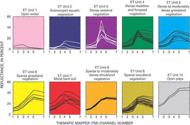
These data were released prior to the October 1, 2016 effective date for the USGS’s policy dictating the review, approval, and release of scientific data as referenced in USGS Survey Manual Chapter 502.8 Fundamental Science Practices: Review and Approval of Scientific Data for Release. The raster-based classification of evapotranspiration (ET) units is for nine major discharge areas in the Death Valley regional flow system. The ET units delineate general areas of similar vegetation and soil-moisture conditions. Classifications were derived from Landsat Thematic Mapper imagery data acquired June 13, 1992; Sept. 1, 1992; and June 21, 1989.
|

|
