Filters: Tags: Decision Support (X)
613 results (8ms)|
Filters
|

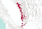
The Nature Conservancy (TNC) has derived climate suitability forecasts for most species of trees and shrubs considered to be ecological dominants of terrestrial Californian habitat types. Our plant projections are compiled as decision support tools to help Conservancy project staff, as well as our external partners, develop the necessary plans, priorities and strategies to successfully adapt to uncertain changes in future climate. In the recently completed Southern Sierra Partnership's 2010 Climate-Adapted Conservation Plan for the Southern Sierra Nevada and Tehachapi Mountains, species and habitat forecasts shown here informed the development of a regional conservation design that explicitly incorporates long-term...
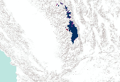
The Nature Conservancy (TNC) has derived climate suitability forecasts for most species of trees and shrubs considered to be ecological dominants of terrestrial Californian habitat types. Our plant projections are compiled as decision support tools to help Conservancy project staff, as well as our external partners, develop the necessary plans, priorities and strategies to successfully adapt to uncertain changes in future climate. In the recently completed Southern Sierra Partnership's 2010 Climate-Adapted Conservation Plan for the Southern Sierra Nevada and Tehachapi Mountains, species and habitat forecasts shown here informed the development of a regional conservation design that explicitly incorporates long-term...

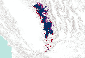
The Nature Conservancy (TNC) has derived climate suitability forecasts for most species of trees and shrubs considered to be ecological dominants of terrestrial Californian habitat types. Our plant projections are compiled as decision support tools to help Conservancy project staff, as well as our external partners, develop the necessary plans, priorities and strategies to successfully adapt to uncertain changes in future climate. In the recently completed Southern Sierra Partnership's 2010 Climate-Adapted Conservation Plan for the Southern Sierra Nevada and Tehachapi Mountains, species and habitat forecasts shown here informed the development of a regional conservation design that explicitly incorporates long-term...

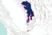
The Nature Conservancy (TNC) has derived climate suitability forecasts for most species of trees and shrubs considered to be ecological dominants of terrestrial Californian habitat types. Our plant projections are compiled as decision support tools to help Conservancy project staff, as well as our external partners, develop the necessary plans, priorities and strategies to successfully adapt to uncertain changes in future climate. In the recently completed Southern Sierra Partnership's 2010 Climate-Adapted Conservation Plan for the Southern Sierra Nevada and Tehachapi Mountains, species and habitat forecasts shown here informed the development of a regional conservation design that explicitly incorporates long-term...
The Nature Conservancy (TNC) has derived climate suitability forecasts for most species of trees and shrubs considered to be ecological dominants of terrestrial Californian habitat types. Our plant projections are compiled as decision support tools to help Conservancy project staff, as well as our external partners, develop the necessary plans, priorities and strategies to successfully adapt to uncertain changes in future climate. In the recently completed Southern Sierra Partnership's 2010 Climate-Adapted Conservation Plan for the Southern Sierra Nevada and Tehachapi Mountains, species and habitat forecasts shown here informed the development of a regional conservation design that explicitly incorporates long-term...
The Nature Conservancy (TNC) has derived climate suitability forecasts for most species of trees and shrubs considered to be ecological dominants of terrestrial Californian habitat types. Our plant projections are compiled as decision support tools to help Conservancy project staff, as well as our external partners, develop the necessary plans, priorities and strategies to successfully adapt to uncertain changes in future climate. In the recently completed Southern Sierra Partnership's 2010 Climate-Adapted Conservation Plan for the Southern Sierra Nevada and Tehachapi Mountains, species and habitat forecasts shown here informed the development of a regional conservation design that explicitly incorporates long-term...

The Nature Conservancy (TNC) has derived climate suitability forecasts for most species of trees and shrubs considered to be ecological dominants of terrestrial Californian habitat types. Our plant projections are compiled as decision support tools to help Conservancy project staff, as well as our external partners, develop the necessary plans, priorities and strategies to successfully adapt to uncertain changes in future climate. In the recently completed Southern Sierra Partnership's 2010 Climate-Adapted Conservation Plan for the Southern Sierra Nevada and Tehachapi Mountains, species and habitat forecasts shown here informed the development of a regional conservation design that explicitly incorporates long-term...

The Nature Conservancy (TNC) has derived climate suitability forecasts for most species of trees and shrubs considered to be ecological dominants of terrestrial Californian habitat types. Our plant projections are compiled as decision support tools to help Conservancy project staff, as well as our external partners, develop the necessary plans, priorities and strategies to successfully adapt to uncertain changes in future climate. In the recently completed Southern Sierra Partnership's 2010 Climate-Adapted Conservation Plan for the Southern Sierra Nevada and Tehachapi Mountains, species and habitat forecasts shown here informed the development of a regional conservation design that explicitly incorporates long-term...

The Nature Conservancy (TNC) has derived climate suitability forecasts for most species of trees and shrubs considered to be ecological dominants of terrestrial Californian habitat types. Our plant projections are compiled as decision support tools to help Conservancy project staff, as well as our external partners, develop the necessary plans, priorities and strategies to successfully adapt to uncertain changes in future climate. In the recently completed Southern Sierra Partnership's 2010 Climate-Adapted Conservation Plan for the Southern Sierra Nevada and Tehachapi Mountains, species and habitat forecasts shown here informed the development of a regional conservation design that explicitly incorporates long-term...
The Nature Conservancy (TNC) has derived climate suitability forecasts for most species of trees and shrubs considered to be ecological dominants of terrestrial Californian habitat types. Our plant projections are compiled as decision support tools to help Conservancy project staff, as well as our external partners, develop the necessary plans, priorities and strategies to successfully adapt to uncertain changes in future climate. In the recently completed Southern Sierra Partnership's 2010 Climate-Adapted Conservation Plan for the Southern Sierra Nevada and Tehachapi Mountains, species and habitat forecasts shown here informed the development of a regional conservation design that explicitly incorporates long-term...
This project initiated the first large-scale Tribal government discussions on the relationship of scientific research and traditional knowledge in the activities of the NPLCC. The project: 1. Reviewed existing approaches and protocols related to scientific research and traditional knowledge in the Pacific Northwest, characterized different types of traditional knowledge and the contexts in which these are encountered; 2. Initiated discussions among the 21 member Tribes of the Northwest Indian Fisheries Commission (all other Tribes are welcome to join); 3. Reported on their views; 4. Proposed a framework for the use of TK based on discussions and presented it for a possible consensus by all participants; and 5. Conducted...
Categories: Data,
Project;
Types: Map Service,
OGC WFS Layer,
OGC WMS Layer,
OGC WMS Service;
Tags: 2012,
Academics & scientific researchers,
Decision Support,
Federal resource managers,
Informing Conservation Delivery,
The central objective of this project was to answer two questions: 1) how downscaled climate datasets, modeled vegetation changes, and information on estimated species sensitivities can be used to develop climate change adaptation strategies, and 2) how model results and datasets can be made more useful for informing the management of species and landscapes. To answer these questions, we identified enthusiastic partners working in two very different complex landscapes within the North Pacific Landscape Conservation Cooperative (NPLCC): 1) the British Columbia Park system, specifically the midcoast region, and 2) the National Wildlife Refuge system in the Willamette Valley, OR. The issues and concerns of each group...
Categories: Data;
Tags: Academics & scientific researchers,
B.C.,
BC Provincial parks,
British Columbia,
Conservation Planning,
This project developed a soil vulnerability index and map indicating where forest cover will be most affected by climate change. Using this map, researchers developed a greater understanding of potential changes in soil moisture and temperature regimes under future climate conditions. They then evaluated how this information could be used to improve vegetation models across the landscape. They compared the results of different modeling approaches to the soil vulnerability map, synthesized the state of knowledge and uncertainty, and introduced management implications for action.
Categories: Data,
Project;
Types: Map Service,
OGC WFS Layer,
OGC WMS Layer,
OGC WMS Service;
Tags: 2011,
AK,
AK,
AK,
AK,
This project will create a targeted and easily understandable guide to tools that support landscape-level planning in the face of climate change for NPLCC partners. The guide will build on previous NPLCC research on decision support needs with an emphasis on tools currently in use in the region. A survey of NPLCC partners will discover who is currently using or planning to use tools in the region, tools they are using, how well these tools are meeting their needs, and regional and outside experts engaged in tool use. Additional tools research will provide information on tools not currently in use in the region that could also provide needed functionality.
Categories: Data;
Types: Map Service,
OGC WFS Layer,
OGC WMS Layer,
OGC WMS Service;
Tags: Academics & scientific researchers,
Ak-1,
Alaska,
British Columbia,
CA-2,
FY2014The goals for the project are1) Develop a Walker River Vision document which will include Traditional Ecological Knowledge (TEK) of the traditional plants, wildlife, fish and water located on the reservation and traditional hunting/ gathering areas of the Agai Dicutta Numa (Walker River Paiutes) for use in future resource management planning and cultural sustainability..2) Develop a pilot project along the Walker River on the reservation by planting willows and other traditional plants to determine best practices for re-vegetation.This project will focus on GBLCC Goal 2: Focus science and management actions to sustain natural resources in the context of changing environmental conditions.The proposed project...
Categories: Data,
Project;
Types: Map Service,
OGC WFS Layer,
OGC WMS Layer,
OGC WMS Service;
Tags: Data Management and Integration,
Decision Support,
Great Basin,
Great Basin,
Great Basin,
The Canadian portion of the Crown of the Continent (CCoC) ecosystem has been identified as crucial for wolverines north of the US border to rescue or supply individuals and genes through dispersal to the highly fragmented population in the northern US Rocky Mountains. Highway 3, motorized recreation, and a growing resource extraction industry, however, increasingly fragment this critical landscape. This project will capitalize on multi-year wolverine occupancy and genetic data collected noninvasively in a >40,000 km2 area encompassing the core protected areas of the central Canadian Rocky Mountains to the north; and Glacier-Waterton Lakes National Park complex in the south. Our goal is to obtain spatially-explicit...
Categories: Data,
Project;
Types: Map Service,
OGC WFS Layer,
OGC WMS Layer,
OGC WMS Service;
Tags: Alberta,
Alpine,
Applications and Tools,
British Columbia,
Climate Change,
WGFD has a quantity of GPS-based animal movement data available for processing. In order to fully integrate this data into existing statewide migration route data layers and/or to use it to develop modeled migration corridor data layers, it must be reviewed, organized appropriately, analyzed, modeled and finally structured to allow seamless integration. The objective of this proposal is to review and examine the data, organize it meaningfully, and present it initially in combination with existing migration routes in order to represent generalized big game migration corridors across the landscapes of Wyoming. This is anticipated as a “first look” product, and serve as a basis for future work to more fully analyze...
Categories: Data,
Project;
Types: Map Service,
OGC WFS Layer,
OGC WMS Layer,
OGC WMS Service;
Tags: 2010,
2012,
CO-2,
CO-3,
CO-3,
This project evaluates the connections between climate change impacts and health in Bristol Bay communities. Climate change impacts were assessed through the lens of public health, with an eye towards the potential effects on disease, injury, food and water security, and mental health. Three focal communities were included in this assessment: Nondalton, a lake community, Levelock, a river community, and Pilot Point, a coastal community. The resulting assessment reports will be used to assist focal communities, as well as neighboring communities, in addressing climate-change related issues.
Categories: Data,
Project;
Types: Map Service,
OGC WFS Layer,
OGC WMS Layer,
OGC WMS Service;
Tags: CLIMATE CHANGE IMPACT ASSESSMENT MODELS,
CLIMATE CHANGE IMPACT ASSESSMENT MODELS,
COASTAL AREAS,
COASTAL AREAS,
Decision Support,
We propose to support the revision and implementation of the South Atlantic Landscape Conservation Cooperative’s Conservation Blueprint by integrating its Ecosystem Indicators into a structured decision support system that makes explicit how the Indicators are interrelated and how these will respond to management and policy interventions aimed at improving the conservation status of the South Atlantic region. Our specific objectives are to (1) develop ecological production functions that predict theecological impacts of selected conservation actions relative to current conditions, and to propagate these impacts through other affected systems or functions; (2) codify protocols for updating and curating geospatial...
Categories: Data,
Project;
Types: Map Service,
OGC WFS Layer,
OGC WMS Layer,
OGC WMS Service;
Tags: 2015,
ANTHROPOGENIC/HUMAN INFLUENCED ECOSYSTEMS,
AQUATIC ECOSYSTEMS,
Academics & scientific researchers,
Applications and Tools,
The Prairie Pothole Region (PPR) of the north-central U.S. and south-central Canada contains millions of small prairie wetlands that provide critical habitat to many migrating and breeding waterbirds. Due to their small size and the relatively dry climate of the region, these wetlands are considered at high risk for negative climate change effects as temperatures increase. To estimate the potential impacts of climate change on breeding waterbirds, we predicted current and future distributions of species common in the PPR using species distribution models (SDMs). We created regional-scale SDMs for the U.S. PPR using Breeding Bird Survey occurrence records for 1971–2011 and wetland, upland, and climate variables....
Categories: Data,
Publication;
Types: Citation,
Map Service,
OGC WFS Layer,
OGC WMS Layer,
OGC WMS Service;
Tags: 2010,
2011,
2012,
Climate change,
Conservation NGOs,
|

|
