Filters: Tags: Durham County (X) > Date Range: {"choice":"year"} (X)
9 results (67ms)|
Filters
Date Types (for Date Range)
Contacts
Categories Tag Types Tag Schemes |
These datasets contain information used to compile the report (USGS OFR 2019-1077). It contains water-quality data, analytical results of field blanks, and analytical results for environmental and replicate sample sets for surface-water samples collected during water years 2016 and 2017 for the Triangle Area Water Supply Monitoring Program (TAWSMP).
The U.S. Geological Survey and a consortium of local governments in North Carolina have partnered together to track water quality and quantity conditions in several of the area’s water-supply reservoirs and streams, known as the Triangle Area Water Supply Monitoring Project (TAWSMP). This data release contains the associated data described in the Open-File Report, "Triangle Area Water Supply Monitoring Project, North Carolina-Overview of Hydrologic and Water-Quality Monitoring Activities and Data Quality Assurance". These datasets were collected during October 2019 - September 2022 (Water Years 2020-2022). The data release includes nine items: [Triangle_2020_22_Figure_1.pdf]: This figure shows site locations and...
Categories: Data;
Tags: Chatham County,
Durham County,
North Carolina,
Orange County,
USGS Science Data Catalog (SDC),
As part of the Triangle Area Water Supply Monitoring Program, the U.S. Geological Survey conducted a study to evaluate the occurrence and distribution of mercury in 14 streams and 15 reservoirs in the Triangle area of North Carolina. This Data Release contains the associated data described in the Scientific Investigations Report, "Occurrence and Distribution of Mercury in Streams and Reservoirs in the Triangle Area of North Carolina, July 2007 – June 2009". Water samples were collected seasonally between July 2007 and June 2009 for laboratory analysis of mercury, organic carbon, chlorophyll a, sulfate, and suspended sediment. Field measurements of dissolved oxygen, pH, water temperature, and specific conductance...
Categories: Data;
Tags: Aquatic Biology,
Chatham County,
Durham County,
Environmental Health,
Hydrology,
These datasets contain information used to compile the report (USGS OFR 2021-1020). It contains water-quality data, analytical results of field blanks, and analytical results for environmental and replicate sample sets for surface-water samples collected during water years 2018 and 2019 for the Triangle Area Water Supply Monitoring Program (TAWSMP).
These datasets contain information used to compile the report (USGS OFR 2016-1137). It contains water-quality data, analytical results of field blanks, and analytical results for environmental and replicate sample sets for surface-water samples collected during water years 2012 and 2013 for the Triangle Area Water Supply Monitoring Program (TAWSMP). The water-quality data contained in appendix 1 are field paramters and the analytical results for the constituents analyzed for the project. Appendix 2 contains the results of the field blanks, and the results for the environmental and replicate sample sets are presented in appendix 3.
Types: Citation;
Tags: Chatham County,
Durham County,
North Carolina,
Orange County,
USGS Science Data Catalog (SDC),
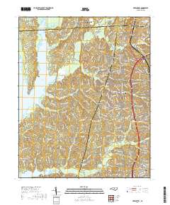
Layered geospatial PDF 7.5 Minute Quadrangle Map. Layers of geospatial data include orthoimagery, roads, grids, geographic names, elevation contours, hydrography, and other selected map features. This map is derived from GIS (geospatial information system) data. It represents a repackaging of GIS data in traditional map form, not creation of new information. The geospatial data in this map are from selected National Map data holdings and other government sources.
This U.S. Geological Survey Data Release contains the associated data described in the Scientific Investigations Report, "Trends in water quality of selected streams and reservoirs used for water supply in the Triangle area of North Carolina, 1989-2013". Since 1989, the U.S. Geological Survey and a consortium of local governments have tracked water-quality conditions and trends in the water-supply reservoirs and streams in the Triangle area of North Carolina located within the upper Cape Fear and Neuse River Basins. Temporal trends in water-quality were analyzed for thirteen stream and eight reservoir sites. Seventeen water-quality parameters and constituents were examined at these sites.
These datasets contain information used to compile the report (USGS OFR 2017-1068). It contains water-quality data, analytical results of field blanks, and analytical results for environmental and replicate sample sets for surface-water samples collected during water years 2014 and 2015 for the Triangle Area Water Supply Monitoring Program (TAWSMP). The water-quality data contained in appendix 1 are field parameters and the analytical results for the constituents analyzed for the project. Appendix 2 contains the results of the field blanks, and the results for the environmental and replicate sample sets are presented in appendix 3.
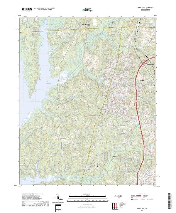
Layered geospatial PDF 7.5 Minute Quadrangle Map. Layers of geospatial data include orthoimagery, roads, grids, geographic names, elevation contours, hydrography, and other selected map features. This map is derived from GIS (geospatial information system) data. It represents a repackaging of GIS data in traditional map form, not creation of new information. The geospatial data in this map are from selected National Map data holdings and other government sources.
|

|
