Filters: Tags: Ecosystems (X) > partyWithName: Conservation Biology Institute (X)
24 results (27ms)|
Filters
Date Range
Tag Schemes |

This metadata references the polygonal ARC/INFO GIS cover showing the current and historic distribution of potential habitat, or range, of the Greater Sage-grouse (Centrocercus urophasianus) and Gunnison Sage-grouse (Centrocercus minimus) in Western North America. This data was initially researched and compiled by Dr. Michael A. Schroeder, research biologist for the Washington State Department of Fish and Wildlife. The initial draft of current and historic range data was mapped and submitted to state, federal, or provincial natural resource agencies and other experts for review, comment, and editing. The final product represents the best available science and expert review available at the time of compilation. ...

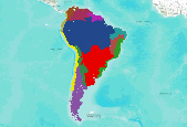
This dataset shows innundation from the terrestrial ecosystems (reference classification) of South America, Central America, and Mexico. South America: This dataset represents Ecological System patches using various reference datasets. Original data generarated from 2000 era data, modeled in 2005 and updated in 2008 and 2010.Originally, this project developed a GIS modeling approach, using a variety of abiotic and biotic data sets, to produce a map of the distribution of Latin America and Caribbean (LAC) ecological systems throughout South America for use in ecoregional assessments. Ecological systems, defined as spatially co-occuring assemblages of vegetation types sharing a common underlying substrate, ecological...

This dataset was extracted from the terrestrial ecosystems of South America dataset. South America: This dataset represents Ecological System patches using various reference datasets. Original data generarated from 2000 era data, modeled in 2005 and updated in 2008 and 2010.Originally, this project developed a GIS modeling approach, using a variety of abiotic and biotic data sets, to produce a map of the distribution of Latin America and Caribbean (LAC) ecological systems throughout South America for use in ecoregional assessments. Ecological systems, defined as spatially co-occuring assemblages of vegetation types sharing a common underlying substrate, ecological process, or gradient, were identified for all...

This metadata references the polygonal ARC/INFO GIS cover showing the current and historic distribution of potential habitat, or range, of the Greater Sage-grouse (Centrocercus urophasianus) and Gunnison Sage-grouse (Centrocercus minimus) in Western North America. This data was initially researched and compiled by Dr. Michael A. Schroeder, research biologist for the Washington State Department of Fish and Wildlife. The initial draft of current and historic range data was mapped and submitted to state, federal, or provincial natural resource agencies and other experts for review, comment, and editing. The final product represents the best available science and expert review available at the time of compilation. ...

This dataset was extracted from the terrestrial ecosystems of South America dataset. South America: This dataset represents Ecological System patches using various reference datasets. Original data generarated from 2000 era data, modeled in 2005 and updated in 2008 and 2010.Originally, this project developed a GIS modeling approach, using a variety of abiotic and biotic data sets, to produce a map of the distribution of Latin America and Caribbean (LAC) ecological systems throughout South America for use in ecoregional assessments. Ecological systems, defined as spatially co-occuring assemblages of vegetation types sharing a common underlying substrate, ecological process, or gradient, were identified for all...

This dataset shows landcover from the terrestrial ecosystems (reference classification) of South America, Central America, and Mexico. South America: This dataset represents Ecological System patches using various reference datasets. Original data generarated from 2000 era data, modeled in 2005 and updated in 2008 and 2010.Originally, this project developed a GIS modeling approach, using a variety of abiotic and biotic data sets, to produce a map of the distribution of Latin America and Caribbean (LAC) ecological systems throughout South America for use in ecoregional assessments. Ecological systems, defined as spatially co-occuring assemblages of vegetation types sharing a common underlying substrate, ecological...

This dataset shows bioclimate from the terrestrial ecosystems (reference classification) of South America, Central America, and Mexico. South America: This dataset represents Ecological System patches using various reference datasets. Original data generarated from 2000 era data, modeled in 2005 and updated in 2008 and 2010.Originally, this project developed a GIS modeling approach, using a variety of abiotic and biotic data sets, to produce a map of the distribution of Latin America and Caribbean (LAC) ecological systems throughout South America for use in ecoregional assessments. Ecological systems, defined as spatially co-occuring assemblages of vegetation types sharing a common underlying substrate, ecological...

This dataset shows dominant phenology from the terrestrial ecosystems (reference classification) of South America, Central America, and Mexico. South America: This dataset represents Ecological System patches using various reference datasets. Original data generarated from 2000 era data, modeled in 2005 and updated in 2008 and 2010.Originally, this project developed a GIS modeling approach, using a variety of abiotic and biotic data sets, to produce a map of the distribution of Latin America and Caribbean (LAC) ecological systems throughout South America for use in ecoregional assessments. Ecological systems, defined as spatially co-occuring assemblages of vegetation types sharing a common underlying substrate,...

South America: This dataset represents Ecological System patches using various reference datasets. Original data generarated from 2000 era data, modeled in 2005 and updated in 2008 and 2010.Originally, this project developed a GIS modeling approach, using a variety of abiotic and biotic data sets, to produce a map of the distribution of Latin America and Caribbean (LAC) ecological systems throughout South America for use in ecoregional assessments. Ecological systems, defined as spatially co-occuring assemblages of vegetation types sharing a common underlying substrate, ecological process, or gradient, were identified for all of LAC in a recent classification effort by NatureServe (Josse et. al., 2003), but the...

La comprensión del funcionamiento de los elementos que componen la biodiversidad es uno de los grandes retos que enfrentan los profesionales de la conservación. Particularmente al tener presente la gran verdad de nuestra ignorancia al respecto. Sin embargo, esto debe ser un estímulo más que una depresión en el camino. La formulación de un escenario que muestre cómo creemos que los componentes de la biodiversidad funcionan puede apoyar el proceso de análisis y comprensión de las complejidades que determinan el elemento de conservación. El escenario de funcionamiento ecológico es posible representarlo en forma abstracta o simplificada definiendo las relaciones entre partes de los ecosistemas así como las transiciones...

La comprensión del funcionamiento de los elementos que componen la biodiversidad es uno de los grandes retos que enfrentan los profesionales de la conservación. Particularmente al tener presente la gran verdad de nuestra ignorancia al respecto. Sin embargo, esto debe ser un estímulo más que una depresión en el camino. La formulación de un escenario que muestre cómo creemos que los componentes de la biodiversidad funcionan puede apoyar el proceso de análisis y comprensión de las complejidades que determinan el elemento de conservación. El escenario de funcionamiento ecológico es posible representarlo en forma abstracta o simplificada definiendo las relaciones entre partes de los ecosistemas así como las transiciones...

This dataset shows physiography from the terrestrial ecosystems (reference classification) of South America, Central America, and Mexico. South America: This dataset represents Ecological System patches using various reference datasets. Original data generarated from 2000 era data, modeled in 2005 and updated in 2008 and 2010.Originally, this project developed a GIS modeling approach, using a variety of abiotic and biotic data sets, to produce a map of the distribution of Latin America and Caribbean (LAC) ecological systems throughout South America for use in ecoregional assessments. Ecological systems, defined as spatially co-occuring assemblages of vegetation types sharing a common underlying substrate, ecological...

This dataset shows biogeographic province from the terrestrial ecosystems (reference classification) of South America, Central America, and Mexico. South America: This dataset represents Ecological System patches using various reference datasets. Original data generarated from 2000 era data, modeled in 2005 and updated in 2008 and 2010.Originally, this project developed a GIS modeling approach, using a variety of abiotic and biotic data sets, to produce a map of the distribution of Latin America and Caribbean (LAC) ecological systems throughout South America for use in ecoregional assessments. Ecological systems, defined as spatially co-occuring assemblages of vegetation types sharing a common underlying substrate,...
La comprensión del funcionamiento de los elementos que componen la biodiversidad es uno de los grandes retos que enfrentan los profesionales de la conservación. Particularmente al tener presente la gran verdad de nuestra ignorancia al respecto. Sin embargo, esto debe ser un estímulo más que una depresión en el camino. La formulación de un escenario que muestre cómo creemos que los componentes de la biodiversidad funcionan puede apoyar el proceso de análisis y comprensión de las complejidades que determinan el elemento de conservación. El escenario de funcionamiento ecológico es posible representarlo en forma abstracta o simplificada definiendo las relaciones entre partes de los ecosistemas así como las transiciones...

This map presents information about the terrestrial ecosystems in Africa, and was developed as part of the United States Geological Surveyâs (USGS) effort to model the distribution of terrestrial ecosystems using the geospatial mapping methodology that was developed from a deductive, biophysical stratification approach to delineate ecosystems by their major structural elements (Sayre and others, 2009). Each major structural component of ecosystems (land surface forms, surficial lithology, bioclimates, topographic moisture potential, and so forth) was modeled and then spatially combined to produce a new map of biophysical settings, termed ecosystem structural footprints. These ecosystem structure units characterize...

South America: This dataset represents Ecological System patches using various reference datasets. Original data generarated from 2000 era data, modeled in 2005 and updated in 2008 and 2010.Originally, this project developed a GIS modeling approach, using a variety of abiotic and biotic data sets, to produce a map of the distribution of Latin America and Caribbean (LAC) ecological systems throughout South America for use in ecoregional assessments. Ecological systems, defined as spatially co-occuring assemblages of vegetation types sharing a common underlying substrate, ecological process, or gradient, were identified for all of LAC in a recent classification effort by NatureServe (Josse et. al., 2003), but the...

This dataset was extracted from the Ecosystems of Central America dataset (TNC / NatureServe). Using the terrestrial ecosystem map produced by the World Bank and CCAD in 2000, The Nature Conservancy and NatureServe, crosswalked the aforementioned ecosystem classification with the NatureServe standard classification for Latin America and the Caribbean (2003). The purpose of this map is to have a consistent ecosystem map for Latin America, as South America has an ecosystem map using the NatureServe classification since 2005. The ecosystem crosswalk was done by Maarten Kappelle, Lenin Corrales, Carmen Josse and Leonardo Sotomayor, and was completed in June 2010. The crosswalk was done in several parts. First, the...

Boundary for floristic regions used for the conservation assessment of Greater Sage-grouse and sagebrush habitat conducted by the Western Association of Fish and Wildlife Agencies. The floristic provinces were digitized from a figure from Miller, R. F., and L. Eddleman. 2001. Spatial and temporal changes of sage-grouse habitat in the sagebrush biome. Oregon State University, Agricultural Experiment Station. Technical Bulletin 151.

Depicts a risk model of invasion of native shrublands (primarily sagebrush ecosystems) by Juniper and Pinyon Pine.

This dataset shows macro biogeographic regions from the terrestrial ecosystems (reference classification) of South America, Central America, and Mexico. South America: This dataset represents Ecological System patches using various reference datasets. Original data generarated from 2000 era data, modeled in 2005 and updated in 2008 and 2010.Originally, this project developed a GIS modeling approach, using a variety of abiotic and biotic data sets, to produce a map of the distribution of Latin America and Caribbean (LAC) ecological systems throughout South America for use in ecoregional assessments. Ecological systems, defined as spatially co-occuring assemblages of vegetation types sharing a common underlying...
|

|
