Filters: Tags: Elevation Theme (X) > partyWithName: USGS - National Geospatial Technical Operations Center (NGTOC) (X)
5 results (13ms)|
Filters
Date Range
Types Contacts Tag Types Tag Schemes |
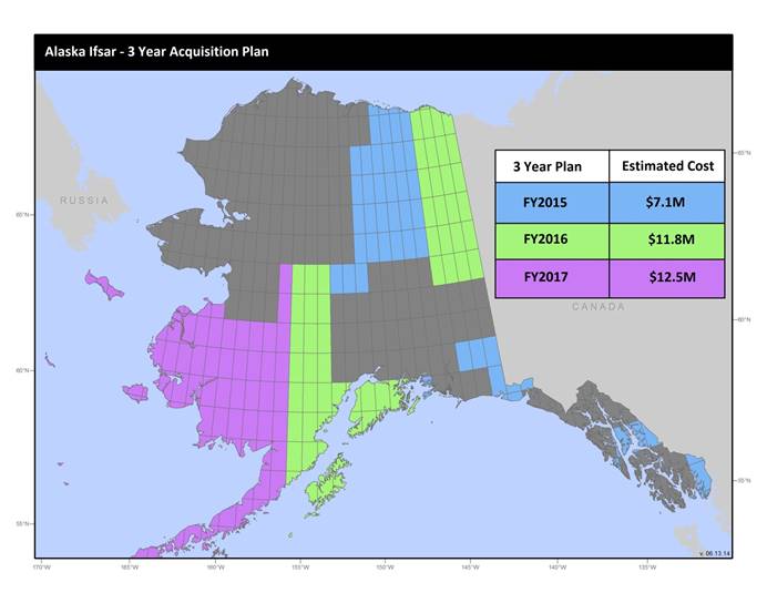
U.S. Geological Survey, Department of the Interior - The annual Alaska IfSAR and DEM acquisition plan is part of the 3DEP initiative to collect high-quality elevation data in the form of interferometric synthetic aperture radar (IfSAR) and light detection and ranging (lidar) data over Alaska. This acquisition plan addresses concerns raised in GAO Report 13-94 regarding geospatial coordination, and supports FGDC data coordination initiatives led by the Department of Interior's Geospatial Information Officer. Mapping a State the size and complexity of Alaska through a partnered effort such as the Alaska Mapping Initiative requires dedicated collaboration and coordination across multiple levels of government. State...
U.S. Geological Survey, Department of the Interior - The annual lidar and DEM acquisition plan is part of the 3DEP initiative to systematically collect enhanced elevation data (Quality Level 2) in the form of high-quality light detection and ranging (lidar) data over the conterminous United States, Hawaii, and the territories on an 8-year schedule. The FY17 acquisition plan currently anticipates collecting 225,000 sq. mi. or more depending on partnerships and other contributions to the plan. Interested parties who wish to become a funding partner with the USGS in FY17 or in future years should contact a USGS Geospatial Liaison - http://liaisons.usgs.gov/geospatial/documents/TNM_Partnership_User_ContactList.pdf....
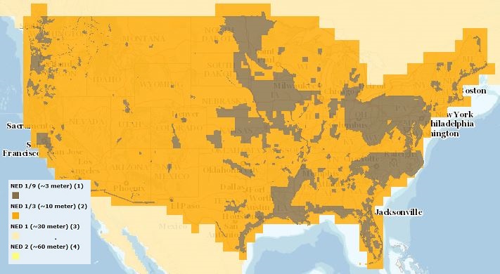
The USGS Elevation Availability service from The National Map (TNM) shows the best available resolution of downloadable elevation data, and is updated approximately every two weeks with National Elevation Dataset (NED) releases. NED 2- (in Alaska only), 1-, and 1/3-arc-second data are staged for download by 1x1 degree tiles in ArcGrid, GridFloat, or IMG formats in The National Map viewer, while NED 1/9 arc-second data is staged by 15x15 minute tiles in IMG format only. For additional information on the NED, go to http://ned.usgs.gov/.

USGS Hill Shade (or Shaded Relief) is a tile cache base map created from the National Elevation Dataset (NED), a seamless dataset of best available raster elevation data for the conterminous United States, Alaska, Hawaii, and Territorial Islands. Derived from the NED using a hill shade technique, this base map represents a continental view showing shaded relief from USGS NED layers at resolutions of 1/3-, 1-, and 2-arc-second (in Alaska only). Shaded relief (or hill shade) function parameters are: point illumination is from the NW (azimuth = 315 degrees), and altitude of the light source is 45 degrees. Color characteristics are the result of applying a color ramp in which RGB values range from white (RGB: 255, 255,...
Types: Citation;
Tags: Base Map Service,
Elevation,
Elevation Theme,
NGDA,
National Geospatial Data Asset,

The USGS Elevation Availability service from The National Map (TNM) shows the best available resolution of downloadable elevation data, and is updated approximately every weeks with 3D Elevation Program (3DEP) releases. Alaska 2 arc-second, 1 arc-second, and 1/3-arc-second data are staged for download by 1x1 degree tiles in ArcGrid, GridFloat, or IMG formats in The National Map viewer, while 1/9 arc-second data is staged by 15x15 minute tiles in IMG format only. For additional information on the 3D Elevation Program (3DEP), go to https://nationalmap.gov/3DEP/.
|

|
