Filters
Date Range
Contacts
Tag Types
Tag Schemes
|

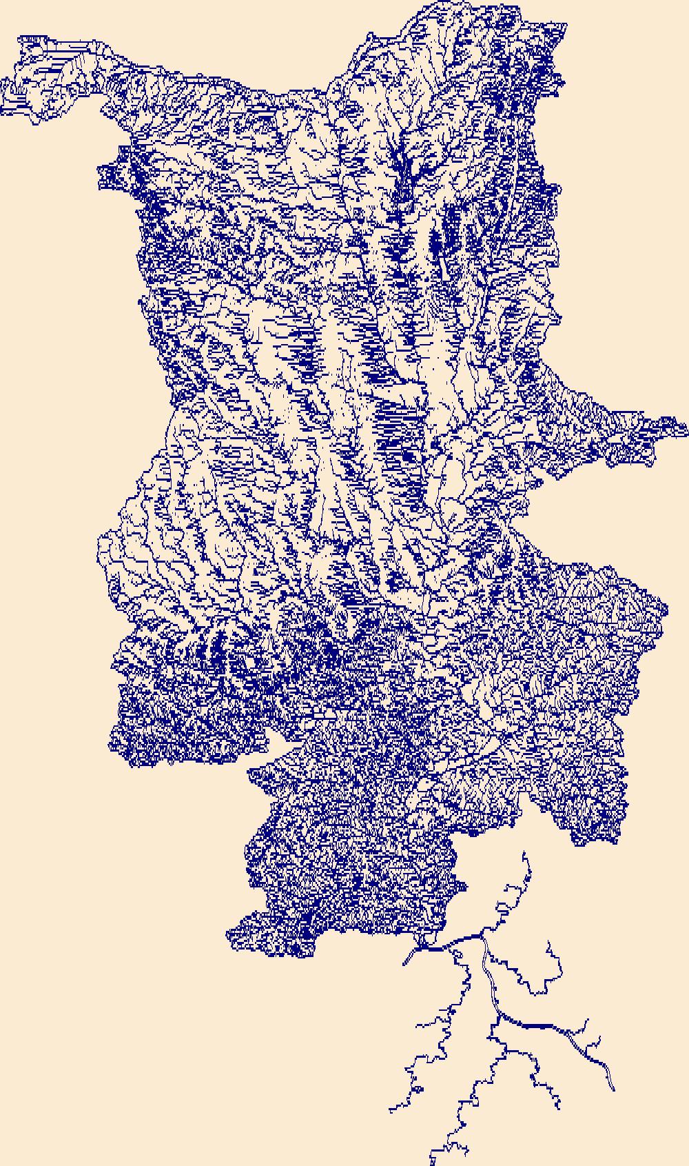
The High Resolution National Hydrography Dataset Plus (NHDPlus HR) is an integrated set of geospatial data layers, including the National Hydrography Dataset (NHD), National Watershed Boundary Dataset (WBD), and 3D Elevation Program Digital Elevation Model (3DEP DEM). The NHDPlus HR combines the NHD, 3DEP DEMs, and WBD to a data suite that includes the NHD stream network with linear referencing functionality, the WBD hydrologic units, elevation-derived catchment areas for each stream segment, "value added attributes" (VAAs), and other features that enhance hydrologic data analysis and routing.
Tags: 4-digit hydrologic unit,
Berkshire County,
CT,
Columbia County,
Connecticut, All tags...
Downloadable Data,
Dutchess County,
Fairfield County,
FileGDB,
HU-4 Subregion,
HU4,
HU4_0110,
Hampden County,
Hartford County,
Hydrography,
Kent County,
Litchfield County,
MA,
Massachusetts,
Middlesex County,
NHDPlus HR Rasters,
NHDPlus High Resolution (NHDPlus HR),
NY,
National Hydrography Dataset (NHD),
National Hydrography Dataset Plus High Resolution (NHDPlus HR),
National Hydrography Dataset Plus High Resolution (NHDPlus HR) Current,
New Haven County,
New London County,
New York,
Providence County,
Putnam County,
RI,
Rhode Island,
Tolland County,
US,
United States,
Washington County,
Westchester County,
Windham County,
Worcester County,
base maps,
cartography,
catchments,
channels,
digital elevation models,
drainage basins,
earthsciences,
environment,
geographic information systems,
geoscientificInformation,
geospatial analysis,
hydrographic datasets,
hydrographic features,
hydrology,
inlandWaters,
lakes,
land surface characteristics,
reservoirs,
river reaches,
rivers,
streamflow,
streamflow data,
streams,
surface water quality,
topography,
water resources,
waterbodies,
watersheds, Fewer tags

The High Resolution National Hydrography Dataset Plus (NHDPlus HR) is an integrated set of geospatial data layers, including the best available National Hydrography Dataset (NHD), the 10-meter 3D Elevation Program Digital Elevation Model (3DEP DEM), and the National Watershed Boundary Dataset (WBD). The NHDPlus HR combines the NHD, 3DEP DEMs, and WBD to create a stream network with linear referencing, feature naming, "value added attributes" (VAAs), elevation-derived catchments, and other features for hydrologic data analysis. The stream network with linear referencing is a system of data relationships applied to hydrographic systems so that one stream reach "flows" into another and "events" can be tied to and traced...
Tags: Ashland County,
Athens County,
Belmont County,
Carroll County,
Columbiana County, All tags...
Coshocton County,
Crawford County,
Downloadable Data,
Fairfield County,
FileGDB,
FileGDB 10.1,
Guernsey County,
HU-4 Subregion,
HU-4 Subregion,
HU4_0504,
Harrison County,
Holmes County,
Hydrography,
Knox County,
Licking County,
Medina County,
Monroe County,
Morgan County,
Morrow County,
Muskingum County,
NHDPlus HR Rasters,
NHDPlus High Resolution (NHDPlus HR),
National Hydrography Dataset (NHD),
National Hydrography Dataset Plus High Resolution (NHDPlus HR),
National Hydrography Dataset Plus High Resolution (NHDPlus HR) Current,
Noble County,
OH,
Ohio,
Perry County,
Portage County,
Richland County,
Stark County,
Summit County,
Tuscarawas County,
US,
United States,
Washington County,
Wayne County,
base maps,
cartography,
catchments,
channels,
digital elevation models,
drainage basins,
earth sciences,
elevation,
environment,
geographic information systems,
geoscientific,
geospatial analysis,
hydrographic datasets,
hydrographic features,
hydrology,
imagery,
inland waters,
lakes,
land surface characteristics,
reservoirs,
river reaches,
rivers,
streamflow,
streamflow data,
streams,
topography,
water bodies,
water quality,
water resources,
watersheds, Fewer tags

The High Resolution National Hydrography Dataset Plus (NHDPlus HR) is an integrated set of geospatial data layers, including the best available National Hydrography Dataset (NHD), the 10-meter 3D Elevation Program Digital Elevation Model (3DEP DEM), and the National Watershed Boundary Dataset (WBD). The NHDPlus HR combines the NHD, 3DEP DEMs, and WBD to create a stream network with linear referencing, feature naming, "value added attributes" (VAAs), elevation-derived catchments, and other features for hydrologic data analysis. The stream network with linear referencing is a system of data relationships applied to hydrographic systems so that one stream reach "flows" into another and "events" can be tied to and traced...
Tags: Abbeville County,
Aiken County,
Alexander County,
Allendale County,
Anderson County, All tags...
Avery County,
Bamberg County,
Barnwell County,
Beaufort County,
Berkeley County,
Buncombe County,
Burke County,
Caldwell County,
Calhoun County,
Catawba County,
Charleston County,
Cherokee County,
Chester County,
Clarendon County,
Cleveland County,
Colleton County,
Dorchester County,
Downloadable Data,
Edgefield County,
Fairfield County,
FileGDB,
FileGDB 10.1,
Gaston County,
Georgetown County,
Greenville County,
Greenwood County,
HU-4 Subregion,
HU-4 Subregion,
HU4_0305,
Hampton County,
Henderson County,
Hydrography,
Iredell County,
Jasper County,
Kershaw County,
Lancaster County,
Laurens County,
Lee County,
Lexington County,
Lincoln County,
McDowell County,
Mecklenburg County,
Mitchell County,
NC,
NHDPlus HR Rasters,
NHDPlus High Resolution (NHDPlus HR),
National Hydrography Dataset (NHD),
National Hydrography Dataset Plus High Resolution (NHDPlus HR),
National Hydrography Dataset Plus High Resolution (NHDPlus HR) Current,
Newberry County,
North Carolina,
Orangeburg County,
Pickens County,
Polk County,
Richland County,
Rutherford County,
SC,
Saluda County,
South Carolina,
Spartanburg County,
Sumter County,
Transylvania County,
US,
Union County,
Union County,
United States,
Watauga County,
Wilkes County,
Williamsburg County,
Yancey County,
York County,
base maps,
cartography,
catchments,
channels,
digital elevation models,
drainage basins,
earth sciences,
elevation,
environment,
geographic information systems,
geoscientific,
geospatial analysis,
hydrographic datasets,
hydrographic features,
hydrology,
imagery,
inland waters,
lakes,
land surface characteristics,
reservoirs,
river reaches,
rivers,
streamflow,
streamflow data,
streams,
topography,
water bodies,
water quality,
water resources,
watersheds, Fewer tags
The High Resolution National Hydrography Dataset Plus (NHDPlus HR) is an integrated set of geospatial data layers, including the best available National Hydrography Dataset (NHD), the 10-meter 3D Elevation Program Digital Elevation Model (3DEP DEM), and the National Watershed Boundary Dataset (WBD). The NHDPlus HR combines the NHD, 3DEP DEMs, and WBD to create a stream network with linear referencing, feature naming, "value added attributes" (VAAs), elevation-derived catchments, and other features for hydrologic data analysis. The stream network with linear referencing is a system of data relationships applied to hydrographic systems so that one stream reach "flows" into another and "events" can be tied to and traced...
Tags: Adams County,
Allen County,
Auglaize County,
Champaign County,
Clark County, All tags...
Clinton County,
Crawford County,
Delaware County,
Downloadable Data,
Fairfield County,
Fayette County,
FileGDB,
FileGDB 10.1,
Franklin County,
Greene County,
Greenup County,
HU-4 Subregion,
HU-4 Subregion,
HU4_0506,
Hardin County,
Highland County,
Hocking County,
Hydrography,
Jackson County,
KY,
Kentucky,
Knox County,
Licking County,
Logan County,
Madison County,
Marion County,
Morrow County,
NHDPlus HR Rasters,
NHDPlus High Resolution (NHDPlus HR),
National Hydrography Dataset (NHD),
National Hydrography Dataset Plus High Resolution (NHDPlus HR),
National Hydrography Dataset Plus High Resolution (NHDPlus HR) Current,
OH,
Ohio,
Perry County,
Pickaway County,
Pike County,
Richland County,
Ross County,
Scioto County,
US,
Union County,
United States,
Vinton County,
Wyandot County,
base maps,
cartography,
catchments,
channels,
digital elevation models,
drainage basins,
earth sciences,
elevation,
environment,
geographic information systems,
geoscientific,
geospatial analysis,
hydrographic datasets,
hydrographic features,
hydrology,
imagery,
inland waters,
lakes,
land surface characteristics,
reservoirs,
river reaches,
rivers,
streamflow,
streamflow data,
streams,
topography,
water bodies,
water quality,
water resources,
watersheds, Fewer tags

The High Resolution National Hydrography Dataset Plus (NHDPlus HR) is an integrated set of geospatial data layers, including the best available National Hydrography Dataset (NHD), the 10-meter 3D Elevation Program Digital Elevation Model (3DEP DEM), and the National Watershed Boundary Dataset (WBD). The NHDPlus HR combines the NHD, 3DEP DEMs, and WBD to create a stream network with linear referencing, feature naming, "value added attributes" (VAAs), elevation-derived catchments, and other features for hydrologic data analysis. The stream network with linear referencing is a system of data relationships applied to hydrographic systems so that one stream reach "flows" into another and "events" can be tied to and traced...
Tags: Allegheny County,
Ashtabula County,
Athens County,
Beaver County,
Belmont County, All tags...
Braxton County,
Brooke County,
Butler County,
Calhoun County,
Carroll County,
Clay County,
Columbiana County,
Crawford County,
Doddridge County,
Downloadable Data,
Fairfield County,
FileGDB,
FileGDB 10.1,
Gallia County,
Geauga County,
Gilmer County,
Greene County,
Guernsey County,
HU-4 Subregion,
HU-4 Subregion,
HU4_0503,
Hancock County,
Harrison County,
Harrison County,
Hocking County,
Hydrography,
Jackson County,
Jefferson County,
Lawrence County,
Lewis County,
Mahoning County,
Marion County,
Marshall County,
Mason County,
Meigs County,
Mercer County,
Monongalia County,
Monroe County,
Morgan County,
NHDPlus HR Rasters,
NHDPlus High Resolution (NHDPlus HR),
National Hydrography Dataset (NHD),
National Hydrography Dataset Plus High Resolution (NHDPlus HR),
National Hydrography Dataset Plus High Resolution (NHDPlus HR) Current,
Noble County,
OH,
Ohio,
Ohio County,
PA,
Pennsylvania,
Perry County,
Pleasants County,
Portage County,
Ritchie County,
Roane County,
Stark County,
Trumbull County,
Tyler County,
US,
United States,
Upshur County,
Venango County,
WV,
Washington County,
Washington County,
Webster County,
West Virginia,
Wetzel County,
Wirt County,
Wood County,
base maps,
cartography,
catchments,
channels,
digital elevation models,
drainage basins,
earth sciences,
elevation,
environment,
geographic information systems,
geoscientific,
geospatial analysis,
hydrographic datasets,
hydrographic features,
hydrology,
imagery,
inland waters,
lakes,
land surface characteristics,
reservoirs,
river reaches,
rivers,
streamflow,
streamflow data,
streams,
topography,
water bodies,
water quality,
water resources,
watersheds, Fewer tags

The High Resolution National Hydrography Dataset Plus (NHDPlus HR) is an integrated set of geospatial data layers, including the National Hydrography Dataset (NHD), National Watershed Boundary Dataset (WBD), and 3D Elevation Program Digital Elevation Model (3DEP DEM). The NHDPlus HR combines the NHD, 3DEP DEMs, and WBD to a data suite that includes the NHD stream network with linear referencing functionality, the WBD hydrologic units, elevation-derived catchment areas for each stream segment, "value added attributes" (VAAs), and other features that enhance hydrologic data analysis and routing.
Tags: 4-digit hydrologic unit,
Bergen County,
Bronx County,
CT,
Connecticut, All tags...
Downloadable Data,
Dutchess County,
Essex County,
Fairfield County,
FileGDB,
HU-4 Subregion,
HU4,
HU4_0203,
Hudson County,
Hunterdon County,
Hydrography,
Kings County,
Mercer County,
Middlesex County,
Monmouth County,
Morris County,
NHDPlus HR Rasters,
NHDPlus High Resolution (NHDPlus HR),
NJ,
NY,
Nassau County,
National Hydrography Dataset (NHD),
National Hydrography Dataset Plus High Resolution (NHDPlus HR),
National Hydrography Dataset Plus High Resolution (NHDPlus HR) Current,
New Haven County,
New Jersey,
New London County,
New York,
New York County,
Orange County,
Passaic County,
Putnam County,
Queens County,
RI,
Rhode Island,
Richmond County,
Rockland County,
Somerset County,
Suffolk County,
Sussex County,
US,
Union County,
United States,
Washington County,
Westchester County,
base maps,
cartography,
catchments,
channels,
digital elevation models,
drainage basins,
earthsciences,
environment,
geographic information systems,
geoscientificInformation,
geospatial analysis,
hydrographic datasets,
hydrographic features,
hydrology,
inlandWaters,
lakes,
land surface characteristics,
reservoirs,
river reaches,
rivers,
streamflow,
streamflow data,
streams,
surface water quality,
topography,
water resources,
waterbodies,
watersheds, Fewer tags
|
|

