Filters: Tags: Fire Island (X) > partyWithName: U.S. Geological Survey (X)
14 results (50ms)|
Filters
Date Range
Types Contacts
Tag Types Tag Schemes |
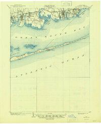
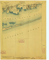
USGS Historical Quadrangle in GeoPDF.
Surveys of the bathymetry and backscatter intensity of the sea floor south of Long Island, New York, were carried out in November 1998 using a Simrad EM1000 multibeam echosounder mounted on the Canadian Coast Guard ship Frederick G. Creed. The purpose of the multibeam echosounder surveys was to explore the bathymetry and backscatter intensity of the sea floor in several areas off the southern coast of Long Island along the 20-meter isobath. Survey areas offshore of Fire Island Inlet, Moriches Inlet, Shinnecock Inlet, and southwest of Montauk Point were about 1 kilometer (km) wide and 10 km long. The area was mapped by the U.S. Geological Survey with support from the Canadian Hydrographic Service and the University...
Types: Citation,
Map Service,
OGC WFS Layer,
OGC WMS Layer,
OGC WMS Service;
Tags: 3-m grid,
Esri binary grid,
Fire Island,
Long Island,
Middle Atlantic Bight,
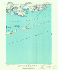
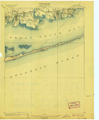
USGS Historical Quadrangle in GeoPDF.
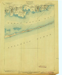
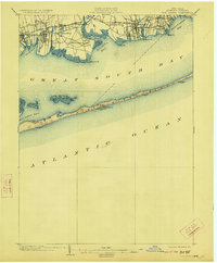
USGS Historical Quadrangle in GeoPDF.
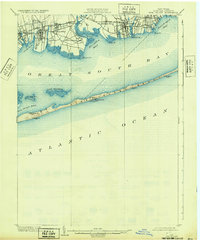
USGS Historical Quadrangle in GeoPDF.
USGS Historical Quadrangle in GeoPDF.
These data are from a 1998 multibeam survey of the sea floor offshore of Fire Island Inlet, New York. There are five datasets: bathymetry grid, shaded-relief image, backscatter intensity image, shaded-relief colored by backscatter intensity image, and trackline navigation. The bathymetry shows the shape of the sea floor. Of particular interest are the size, shape, and orientation of bed forms that may indicate sediment movement. The shaded-relief image provides a visualization of the bathymetry that accentuates small features that cannot be effectively shown as contours alone. The image of backscatter intensity provides qualitative information on the sediment texture and roughness of the sea floor. The image of...
Types: Citation,
Map Service,
OGC WFS Layer,
OGC WMS Layer,
OGC WMS Service;
Tags: Fire Island,
Long Island,
Middle Atlantic Bight,
New York,
New York Bight,
USGS Historical Quadrangle in GeoPDF.
Surveys of the bathymetry and backscatter intensity of the sea floor south of Long Island, New York, were carried out in November 1998 using a Simrad EM1000 multibeam echosounder mounted on the Canadian Coast Guard ship Frederick G. Creed. The purpose of the multibeam echosounder surveys was to explore the bathymetry and backscatter intensity of the sea floor in several areas off the southern coast of Long Island along the 20-meter isobath. Survey areas offshore of Fire Island Inlet, Moriches Inlet, Shinnecock Inlet, and southwest of Montauk Point were about 1 kilometer (km) wide and 10 km long. The area was mapped by the U.S. Geological Survey with support from the Canadian Hydrographic Service and the University...
Surveys of the bathymetry and backscatter intensity of the sea floor south of Long Island, New York, were carried out in November 1998 using a Simrad EM1000 multibeam echosounder mounted on the Canadian Coast Guard ship Frederick G. Creed. The purpose of the multibeam echosounder surveys was to explore the bathymetry and backscatter intensity of the sea floor in several areas off the southern coast of Long Island along the 20-meter isobath. Survey areas offshore of Fire Island Inlet, Moriches Inlet, Shinnecock Inlet, and southwest of Montauk Point were about 1 kilometer (km) wide and 10 km long. The area was mapped by the U.S. Geological Survey with support from the Canadian Hydrographic Service and the University...
Surveys of the bathymetry and backscatter intensity of the sea floor south of Long Island, New York, were carried out in November 1998 using a Simrad EM1000 multibeam echosounder mounted on the Canadian Coast Guard ship Frederick G. Creed. The purpose of the multibeam echosounder surveys was to explore the bathymetry and backscatter intensity of the sea floor in several areas off the southern coast of Long Island along the 20-meter isobath. Survey areas offshore of Fire Island Inlet, Moriches Inlet, Shinnecock Inlet, and southwest of Montauk Point were about 1 kilometer (km) wide and 10 km long. The area was mapped by the U.S. Geological Survey with support from the Canadian Hydrographic Service and the University...
USGS Historical Quadrangle in GeoPDF.
Surveys of the bathymetry and backscatter intensity of the sea floor south of Long Island, New York, were carried out in November 1998 using a Simrad EM1000 multibeam echosounder mounted on the Canadian Coast Guard ship Frederick G. Creed. The purpose of the multibeam echosounder surveys was to explore the bathymetry and backscatter intensity of the sea floor in several areas off the southern coast of Long Island along the 20-meter isobath. Survey areas offshore of Fire Island Inlet, Moriches Inlet, Shinnecock Inlet, and southwest of Montauk Point were about 1 kilometer (km) wide and 10 km long. The area was mapped by the U.S. Geological Survey with support from the Canadian Hydrographic Service and the University...
Types: Citation,
Map Service,
OGC WFS Layer,
OGC WMS Layer,
OGC WMS Service;
Tags: Fire Island,
Long Island,
Middle Atlantic Bight,
New York,
New York Bight,

The U.S. Geological Survey, in cooperation with the National Park Service (NPS), developed a three-dimensional groundwater-flow model to simulate climate-change-related changes in depth to the water table and depth to freshwater/saltwater interfaces for the Fire Island National Seashore, New York. An existing SEAWAT three-dimensional variable-density groundwater flow and transport model (https://doi.org/10.3133/sir20095259) was converted to a MODFLOW–NWT three-dimensional finite-difference groundwater model with the Seawater Intrusion (SWI2) package and recalibrated using the UCODE_2005 automatic calibration software. A management goal for the Fire Island National Seashore is to increase the resiliency and capacity...
|

|
