Filters
Date Range
Extensions
Types
Contacts
Categories
Tag Types
Tag Schemes
|

The Geographic Names Information System (GNIS) is the Federal standard for geographic nomenclature. The U.S. Geological Survey developed the GNIS for the U.S. Board on Geographic Names, a Federal inter-agency body chartered by public law to maintain uniform feature name usage throughout the Government and to promulgate standard names to the public. The GNIS is the official repository of domestic geographic names data; the official vehicle for geographic names use by all departments of the Federal Government; and the source for applying geographic names to Federal electronic and printed products of all types.
Tags: AK,
Alaska,
Aleutians East,
Aleutians West,
Anchorage, All tags...
Antarctica,
Antarctica,
BGN,
Bethel,
Board on Geographic Names,
Borough,
Bristol Bay,
Census Area,
Chugach,
Commonwealth,
Copper River,
County,
Denali,
Dillingham,
District,
Downloadable Data,
Esri File GeoDatabase 10,
Fairbanks North Star,
Feature class,
Feature coordinates,
Feature county,
Feature description,
Feature designation,
Feature history,
Feature indentification,
Feature name,
Feature state,
FileGDB,
GNIS,
Geographic Names,
Geographic Names Full Model,
Geographic Names Information System,
Geographic feature,
Geographic name,
Geographical feature,
Geographical name,
Haines,
Hoonah-Angoon,
Juneau,
Kenai Peninsula,
Ketchikan Gateway,
Kodiak Island,
Kusilvak,
Lake and Peninsula,
Matanuska-Susitna,
Municipio,
National Geographic Names Information System (GNIS),
National Geographic Names Information System (GNIS),
Nome,
North Slope,
Northwest Arctic,
Official feature name,
Outlying Area,
Parish,
Petersburg,
Place name,
Populated Place,
Prince of Wales-Hyder,
Sitka,
Skagway,
Southeast Fairbanks,
State,
Territories,
Territory,
Topographic Map,
U.S. Board on Geographic Names,
U.S. Geological Survey,
US,
USA,
USBGN,
USGS,
United States,
United States,
United States,
Variant name,
Wrangell,
Yakutat,
Yukon-Koyukuk,
antarctic,
database,
economy,
environment,
feature,
gazetteer,
geographic,
geographic names,
geographical,
geography,
geospatial,
imageryBaseMapsEarthCover,
inlandWaters,
location,
map,
name,
place,
placename,
society,
structure,
topographic map,
toponymy, Fewer tags
The Geographic Names Information System (GNIS) is the Federal standard for geographic nomenclature. The U.S. Geological Survey developed the GNIS for the U.S. Board on Geographic Names, a Federal inter-agency body chartered by public law to maintain uniform feature name usage throughout the Government and to promulgate standard names to the public. The GNIS is the official repository of domestic geographic names data; the official vehicle for geographic names use by all departments of the Federal Government; and the source for applying geographic names to Federal electronic and printed products of all types.
Tags: Allen,
Anderson,
Antarctica,
Antarctica,
Atchison, All tags...
BGN,
Barber,
Barton,
Board on Geographic Names,
Borough,
Bourbon,
Brown,
Butler,
Census Area,
Chase,
Chautauqua,
Cherokee,
Cheyenne,
Clark,
Clay,
Cloud,
Coffey,
Comanche,
Commonwealth,
County,
Cowley,
Crawford,
Decatur,
Dickinson,
District,
Doniphan,
Douglas,
Downloadable Data,
Edwards,
Elk,
Ellis,
Ellsworth,
Esri File GeoDatabase 10,
Feature class,
Feature coordinates,
Feature county,
Feature description,
Feature designation,
Feature history,
Feature indentification,
Feature name,
Feature state,
FileGDB,
Finney,
Ford,
Franklin,
GNIS,
Geary,
Geographic Names,
Geographic Names Full Model,
Geographic Names Information System,
Geographic feature,
Geographic name,
Geographical feature,
Geographical name,
Gove,
Graham,
Grant,
Gray,
Greeley,
Greenwood,
Hamilton,
Harper,
Harvey,
Haskell,
Hodgeman,
Jackson,
Jefferson,
Jewell,
Johnson,
KS,
Kansas,
Kearny,
Kingman,
Kiowa,
Labette,
Lane,
Leavenworth,
Lincoln,
Linn,
Logan,
Lyon,
Marion,
Marshall,
McPherson,
Meade,
Miami,
Mitchell,
Montgomery,
Morris,
Morton,
Municipio,
National Geographic Names Information System (GNIS),
National Geographic Names Information System (GNIS),
Nemaha,
Neosho,
Ness,
Norton,
Official feature name,
Osage,
Osborne,
Ottawa,
Outlying Area,
Parish,
Pawnee,
Phillips,
Place name,
Populated Place,
Pottawatomie,
Pratt,
Rawlins,
Reno,
Republic,
Rice,
Riley,
Rooks,
Rush,
Russell,
Saline,
Scott,
Sedgwick,
Seward,
Shawnee,
Sheridan,
Sherman,
Smith,
Stafford,
Stanton,
State,
Stevens,
Sumner,
Territories,
Territory,
Thomas,
Topographic Map,
Trego,
U.S. Board on Geographic Names,
U.S. Geological Survey,
US,
USA,
USBGN,
USGS,
United States,
United States,
United States,
Variant name,
Wabaunsee,
Wallace,
Washington,
Wichita,
Wilson,
Woodson,
Wyandotte,
antarctic,
database,
economy,
environment,
feature,
gazetteer,
geographic,
geographic names,
geographical,
geography,
geospatial,
imageryBaseMapsEarthCover,
inlandWaters,
location,
map,
name,
place,
placename,
society,
structure,
topographic map,
toponymy, Fewer tags
The Geographic Names Information System (GNIS) is the Federal standard for geographic nomenclature. The U.S. Geological Survey developed the GNIS for the U.S. Board on Geographic Names, a Federal inter-agency body chartered by public law to maintain uniform feature name usage throughout the Government and to promulgate standard names to the public. The GNIS is the official repository of domestic geographic names data; the official vehicle for geographic names use by all departments of the Federal Government; and the source for applying geographic names to Federal electronic and printed products of all types.
Tags: Antarctica,
Antarctica,
Aurora,
BGN,
Beadle, All tags...
Bennett,
Board on Geographic Names,
Bon Homme,
Borough,
Brookings,
Brown,
Brule,
Buffalo,
Butte,
Campbell,
Census Area,
Charles Mix,
Clark,
Clay,
Codington,
Commonwealth,
Corson,
County,
Custer,
Davison,
Day,
Deuel,
Dewey,
District,
Douglas,
Downloadable Data,
Edmunds,
Esri File GeoDatabase 10,
Fall River,
Faulk,
Feature class,
Feature coordinates,
Feature county,
Feature description,
Feature designation,
Feature history,
Feature indentification,
Feature name,
Feature state,
FileGDB,
GNIS,
Geographic Names,
Geographic Names Full Model,
Geographic Names Information System,
Geographic feature,
Geographic name,
Geographical feature,
Geographical name,
Grant,
Gregory,
Haakon,
Hamlin,
Hand,
Hanson,
Harding,
Hughes,
Hutchinson,
Hyde,
Jackson,
Jerauld,
Jones,
Kingsbury,
Lake,
Lawrence,
Lincoln,
Lyman,
Marshall,
McCook,
McPherson,
Meade,
Mellette,
Miner,
Minnehaha,
Moody,
Municipio,
National Geographic Names Information System (GNIS),
National Geographic Names Information System (GNIS),
Official feature name,
Oglala Lakota,
Outlying Area,
Parish,
Pennington,
Perkins,
Place name,
Populated Place,
Potter,
Roberts,
SD,
Sanborn,
South Dakota,
Spink,
Stanley,
State,
Sully,
Territories,
Territory,
Todd,
Topographic Map,
Tripp,
Turner,
U.S. Board on Geographic Names,
U.S. Geological Survey,
US,
USA,
USBGN,
USGS,
Union,
United States,
United States,
United States,
Variant name,
Walworth,
Yankton,
Ziebach,
antarctic,
database,
economy,
environment,
feature,
gazetteer,
geographic,
geographic names,
geographical,
geography,
geospatial,
imageryBaseMapsEarthCover,
inlandWaters,
location,
map,
name,
place,
placename,
society,
structure,
topographic map,
toponymy, Fewer tags
The Geographic Names Information System (GNIS) is the Federal standard for geographic nomenclature. The U.S. Geological Survey developed the GNIS for the U.S. Board on Geographic Names, a Federal inter-agency body chartered by public law to maintain uniform feature name usage throughout the Government and to promulgate standard names to the public. The GNIS is the official repository of domestic geographic names data; the official vehicle for geographic names use by all departments of the Federal Government; and the source for applying geographic names to Federal electronic and printed products of all types.
Tags: Aitkin,
Anoka,
Antarctica,
Antarctica,
BGN, All tags...
Becker,
Beltrami,
Benton,
Big Stone,
Blue Earth,
Board on Geographic Names,
Borough,
Brown,
Carlton,
Carver,
Cass,
Census Area,
Chippewa,
Chisago,
Clay,
Clearwater,
Commonwealth,
Cook,
Cottonwood,
County,
Crow Wing,
Dakota,
District,
Dodge,
Douglas,
Downloadable Data,
Esri File GeoDatabase 10,
Faribault,
Feature class,
Feature coordinates,
Feature county,
Feature description,
Feature designation,
Feature history,
Feature indentification,
Feature name,
Feature state,
FileGDB,
Fillmore,
Freeborn,
GNIS,
Geographic Names,
Geographic Names Full Model,
Geographic Names Information System,
Geographic feature,
Geographic name,
Geographical feature,
Geographical name,
Goodhue,
Grant,
Hennepin,
Houston,
Hubbard,
Isanti,
Itasca,
Jackson,
Kanabec,
Kandiyohi,
Kittson,
Koochiching,
Lac qui Parle,
Lake,
Lake of the Woods,
Le Sueur,
Lincoln,
Lyon,
MN,
Mahnomen,
Marshall,
Martin,
McLeod,
Meeker,
Mille Lacs,
Minnesota,
Morrison,
Mower,
Municipio,
Murray,
National Geographic Names Information System (GNIS),
National Geographic Names Information System (GNIS),
Nicollet,
Nobles,
Norman,
Official feature name,
Olmsted,
Otter Tail,
Outlying Area,
Parish,
Pennington,
Pine,
Pipestone,
Place name,
Polk,
Pope,
Populated Place,
Ramsey,
Red Lake,
Redwood,
Renville,
Rice,
Rock,
Roseau,
Scott,
Sherburne,
Sibley,
St. Louis,
State,
Stearns,
Steele,
Stevens,
Swift,
Territories,
Territory,
Todd,
Topographic Map,
Traverse,
U.S. Board on Geographic Names,
U.S. Geological Survey,
US,
USA,
USBGN,
USGS,
United States,
United States,
United States,
Variant name,
Wabasha,
Wadena,
Waseca,
Washington,
Watonwan,
Wilkin,
Winona,
Wright,
Yellow Medicine,
antarctic,
database,
economy,
environment,
feature,
gazetteer,
geographic,
geographic names,
geographical,
geography,
geospatial,
imageryBaseMapsEarthCover,
inlandWaters,
location,
map,
name,
place,
placename,
society,
structure,
topographic map,
toponymy, Fewer tags
The Geographic Names Information System (GNIS) is the Federal standard for geographic nomenclature. The U.S. Geological Survey developed the GNIS for the U.S. Board on Geographic Names, a Federal inter-agency body chartered by public law to maintain uniform feature name usage throughout the Government and to promulgate standard names to the public. The GNIS is the official repository of domestic geographic names data; the official vehicle for geographic names use by all departments of the Federal Government; and the source for applying geographic names to Federal electronic and printed products of all types.
Tags: AL,
Alabama,
Antarctica,
Antarctica,
Autauga, All tags...
BGN,
Baldwin,
Barbour,
Bibb,
Blount,
Board on Geographic Names,
Borough,
Bullock,
Butler,
Calhoun,
Census Area,
Chambers,
Cherokee,
Chilton,
Choctaw,
Clarke,
Clay,
Cleburne,
Coffee,
Colbert,
Commonwealth,
Conecuh,
Coosa,
County,
Covington,
Crenshaw,
Cullman,
Dale,
Dallas,
DeKalb,
District,
Downloadable Data,
Elmore,
Escambia,
Esri File GeoDatabase 10,
Etowah,
Fayette,
Feature class,
Feature coordinates,
Feature county,
Feature description,
Feature designation,
Feature history,
Feature indentification,
Feature name,
Feature state,
FileGDB,
Franklin,
GNIS,
Geneva,
Geographic Names,
Geographic Names Full Model,
Geographic Names Information System,
Geographic feature,
Geographic name,
Geographical feature,
Geographical name,
Greene,
Hale,
Henry,
Houston,
Jackson,
Jefferson,
Lamar,
Lauderdale,
Lawrence,
Lee,
Limestone,
Lowndes,
Macon,
Madison,
Marengo,
Marion,
Marshall,
Mobile,
Monroe,
Montgomery,
Morgan,
Municipio,
National Geographic Names Information System (GNIS),
National Geographic Names Information System (GNIS),
Official feature name,
Outlying Area,
Parish,
Perry,
Pickens,
Pike,
Place name,
Populated Place,
Randolph,
Russell,
Shelby,
St. Clair,
State,
Sumter,
Talladega,
Tallapoosa,
Territories,
Territory,
Topographic Map,
Tuscaloosa,
U.S. Board on Geographic Names,
U.S. Geological Survey,
US,
USA,
USBGN,
USGS,
United States,
United States,
United States,
Variant name,
Walker,
Washington,
Wilcox,
Winston,
antarctic,
database,
economy,
environment,
feature,
gazetteer,
geographic,
geographic names,
geographical,
geography,
geospatial,
imageryBaseMapsEarthCover,
inlandWaters,
location,
map,
name,
place,
placename,
society,
structure,
topographic map,
toponymy, Fewer tags
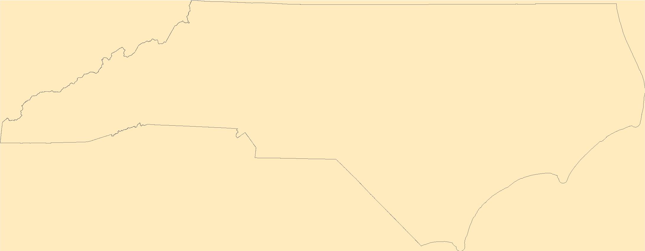
The Geographic Names Information System (GNIS) is the Federal standard for geographic nomenclature. The U.S. Geological Survey developed the GNIS for the U.S. Board on Geographic Names, a Federal inter-agency body chartered by public law to maintain uniform feature name usage throughout the Government and to promulgate standard names to the public. The GNIS is the official repository of domestic geographic names data; the official vehicle for geographic names use by all departments of the Federal Government; and the source for applying geographic names to Federal electronic and printed products of all types.
Tags: Alamance,
Alexander,
Alleghany,
Anson,
Antarctica, All tags...
Antarctica,
Ashe,
Avery,
BGN,
Beaufort,
Bertie,
Bladen,
Board on Geographic Names,
Borough,
Brunswick,
Buncombe,
Burke,
Cabarrus,
Caldwell,
Camden,
Carteret,
Caswell,
Catawba,
Census Area,
Chatham,
Cherokee,
Chowan,
Clay,
Cleveland,
Columbus,
Commonwealth,
County,
Craven,
Cumberland,
Currituck,
Dare,
Davidson,
Davie,
District,
Downloadable Data,
Duplin,
Durham,
Edgecombe,
Esri File GeoDatabase 10,
Feature class,
Feature coordinates,
Feature county,
Feature description,
Feature designation,
Feature history,
Feature indentification,
Feature name,
Feature state,
FileGDB,
Forsyth,
Franklin,
GNIS,
Gaston,
Gates,
Geographic Names,
Geographic Names Full Model,
Geographic Names Information System,
Geographic feature,
Geographic name,
Geographical feature,
Geographical name,
Graham,
Granville,
Greene,
Guilford,
Halifax,
Harnett,
Haywood,
Henderson,
Hertford,
Hoke,
Hyde,
Iredell,
Jackson,
Johnston,
Jones,
Lee,
Lenoir,
Lincoln,
Macon,
Madison,
Martin,
McDowell,
Mecklenburg,
Mitchell,
Montgomery,
Moore,
Municipio,
NC,
Nash,
National Geographic Names Information System (GNIS),
National Geographic Names Information System (GNIS),
New Hanover,
North Carolina,
Northampton,
Official feature name,
Onslow,
Orange,
Outlying Area,
Pamlico,
Parish,
Pasquotank,
Pender,
Perquimans,
Person,
Pitt,
Place name,
Polk,
Populated Place,
Randolph,
Richmond,
Robeson,
Rockingham,
Rowan,
Rutherford,
Sampson,
Scotland,
Stanly,
State,
Stokes,
Surry,
Swain,
Territories,
Territory,
Topographic Map,
Transylvania,
Tyrrell,
U.S. Board on Geographic Names,
U.S. Geological Survey,
US,
USA,
USBGN,
USGS,
Union,
United States,
United States,
United States,
Vance,
Variant name,
Wake,
Warren,
Washington,
Watauga,
Wayne,
Wilkes,
Wilson,
Yadkin,
Yancey,
antarctic,
database,
economy,
environment,
feature,
gazetteer,
geographic,
geographic names,
geographical,
geography,
geospatial,
imageryBaseMapsEarthCover,
inlandWaters,
location,
map,
name,
place,
placename,
society,
structure,
topographic map,
toponymy, Fewer tags
The Geographic Names Information System (GNIS) is the Federal standard for geographic nomenclature. The U.S. Geological Survey developed the GNIS for the U.S. Board on Geographic Names, a Federal inter-agency body chartered by public law to maintain uniform feature name usage throughout the Government and to promulgate standard names to the public. The GNIS is the official repository of domestic geographic names data; the official vehicle for geographic names use by all departments of the Federal Government; and the source for applying geographic names to Federal electronic and printed products of all types.
Tags: Alcona,
Alger,
Allegan,
Alpena,
Antarctica, All tags...
Antarctica,
Antrim,
Arenac,
BGN,
Baraga,
Barry,
Bay,
Benzie,
Berrien,
Board on Geographic Names,
Borough,
Branch,
Calhoun,
Cass,
Census Area,
Charlevoix,
Cheboygan,
Chippewa,
Clare,
Clinton,
Commonwealth,
County,
Crawford,
Delta,
Dickinson,
District,
Downloadable Data,
Eaton,
Emmet,
Esri File GeoDatabase 10,
Feature class,
Feature coordinates,
Feature county,
Feature description,
Feature designation,
Feature history,
Feature indentification,
Feature name,
Feature state,
FileGDB,
GNIS,
Genesee,
Geographic Names,
Geographic Names Full Model,
Geographic Names Information System,
Geographic feature,
Geographic name,
Geographical feature,
Geographical name,
Gladwin,
Gogebic,
Grand Traverse,
Gratiot,
Hillsdale,
Houghton,
Huron,
Ingham,
Ionia,
Iosco,
Iron,
Isabella,
Jackson,
Kalamazoo,
Kalkaska,
Kent,
Keweenaw,
Lake,
Lapeer,
Leelanau,
Lenawee,
Livingston,
Luce,
MI,
Mackinac,
Macomb,
Manistee,
Marquette,
Mason,
Mecosta,
Menominee,
Michigan,
Midland,
Missaukee,
Monroe,
Montcalm,
Montmorency,
Municipio,
Muskegon,
National Geographic Names Information System (GNIS),
National Geographic Names Information System (GNIS),
Newaygo,
Oakland,
Oceana,
Official feature name,
Ogemaw,
Ontonagon,
Osceola,
Oscoda,
Otsego,
Ottawa,
Outlying Area,
Parish,
Place name,
Populated Place,
Presque Isle,
Roscommon,
Saginaw,
Sanilac,
Schoolcraft,
Shiawassee,
St. Clair,
St. Joseph,
State,
Territories,
Territory,
Topographic Map,
Tuscola,
U.S. Board on Geographic Names,
U.S. Geological Survey,
US,
USA,
USBGN,
USGS,
United States,
United States,
United States,
Van Buren,
Variant name,
Washtenaw,
Wayne,
Wexford,
antarctic,
database,
economy,
environment,
feature,
gazetteer,
geographic,
geographic names,
geographical,
geography,
geospatial,
imageryBaseMapsEarthCover,
inlandWaters,
location,
map,
name,
place,
placename,
society,
structure,
topographic map,
toponymy, Fewer tags
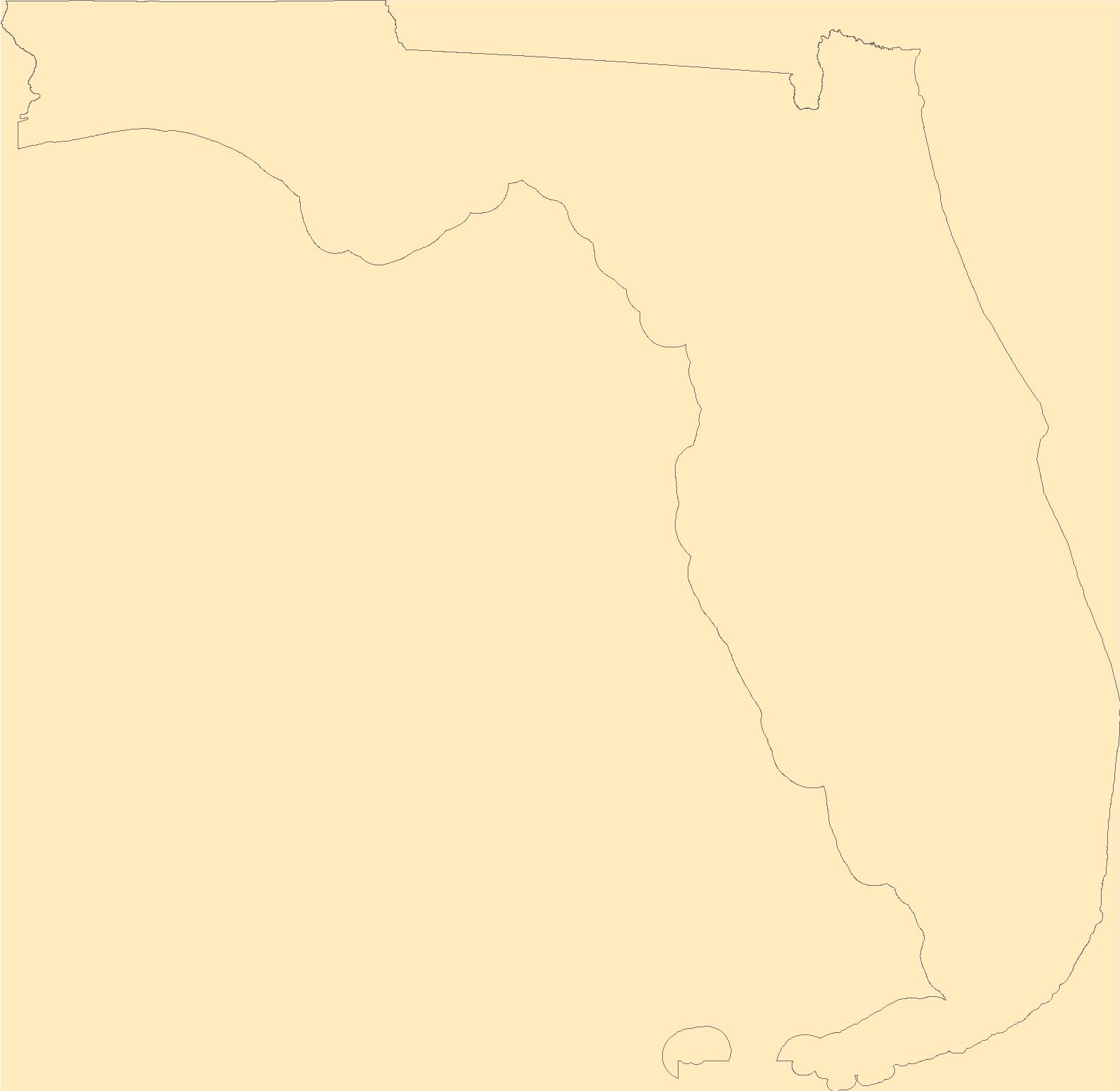
The Geographic Names Information System (GNIS) is the Federal standard for geographic nomenclature. The U.S. Geological Survey developed the GNIS for the U.S. Board on Geographic Names, a Federal inter-agency body chartered by public law to maintain uniform feature name usage throughout the Government and to promulgate standard names to the public. The GNIS is the official repository of domestic geographic names data; the official vehicle for geographic names use by all departments of the Federal Government; and the source for applying geographic names to Federal electronic and printed products of all types.
Tags: Alachua,
Antarctica,
Antarctica,
BGN,
Baker, All tags...
Bay,
Board on Geographic Names,
Borough,
Bradford,
Brevard,
Broward,
Calhoun,
Census Area,
Charlotte,
Citrus,
Clay,
Collier,
Columbia,
Commonwealth,
County,
DeSoto,
District,
Dixie,
Downloadable Data,
Duval,
Escambia,
Esri File GeoDatabase 10,
FL,
Feature class,
Feature coordinates,
Feature county,
Feature description,
Feature designation,
Feature history,
Feature indentification,
Feature name,
Feature state,
FileGDB,
Flagler,
Florida,
Franklin,
GNIS,
Gadsden,
Geographic Names,
Geographic Names Full Model,
Geographic Names Information System,
Geographic feature,
Geographic name,
Geographical feature,
Geographical name,
Gilchrist,
Glades,
Gulf,
Hamilton,
Hardee,
Hendry,
Hernando,
Highlands,
Hillsborough,
Holmes,
Indian River,
Jackson,
Jefferson,
Lafayette,
Lake,
Lee,
Leon,
Levy,
Liberty,
Madison,
Manatee,
Marion,
Martin,
Miami-Dade,
Monroe,
Municipio,
Nassau,
National Geographic Names Information System (GNIS),
National Geographic Names Information System (GNIS),
Official feature name,
Okaloosa,
Okeechobee,
Orange,
Osceola,
Outlying Area,
Palm Beach,
Parish,
Pasco,
Pinellas,
Place name,
Polk,
Populated Place,
Putnam,
Santa Rosa,
Sarasota,
Seminole,
St. Johns,
St. Lucie,
State,
Sumter,
Suwannee,
Taylor,
Territories,
Territory,
Topographic Map,
U.S. Board on Geographic Names,
U.S. Geological Survey,
US,
USA,
USBGN,
USGS,
Union,
United States,
United States,
United States,
Variant name,
Volusia,
Wakulla,
Walton,
Washington,
antarctic,
database,
economy,
environment,
feature,
gazetteer,
geographic,
geographic names,
geographical,
geography,
geospatial,
imageryBaseMapsEarthCover,
inlandWaters,
location,
map,
name,
place,
placename,
society,
structure,
topographic map,
toponymy, Fewer tags
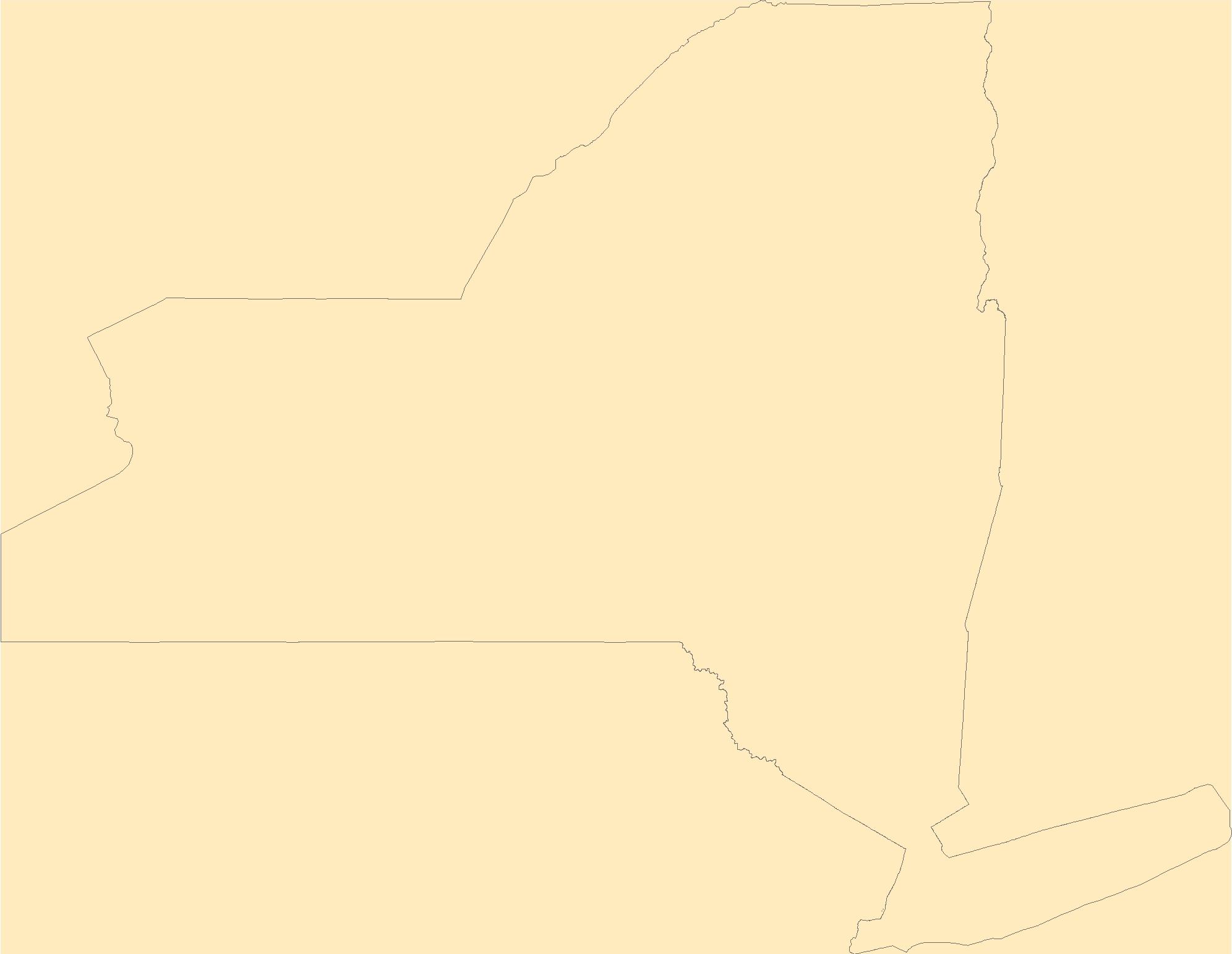
The Geographic Names Information System (GNIS) is the Federal standard for geographic nomenclature. The U.S. Geological Survey developed the GNIS for the U.S. Board on Geographic Names, a Federal inter-agency body chartered by public law to maintain uniform feature name usage throughout the Government and to promulgate standard names to the public. The GNIS is the official repository of domestic geographic names data; the official vehicle for geographic names use by all departments of the Federal Government; and the source for applying geographic names to Federal electronic and printed products of all types.
Tags: Albany,
Allegany,
Antarctica,
Antarctica,
BGN, All tags...
Board on Geographic Names,
Borough,
Bronx,
Broome,
Cattaraugus,
Cayuga,
Census Area,
Chautauqua,
Chemung,
Chenango,
Clinton,
Columbia,
Commonwealth,
Cortland,
County,
Delaware,
District,
Downloadable Data,
Dutchess,
Erie,
Esri File GeoDatabase 10,
Essex,
Feature class,
Feature coordinates,
Feature county,
Feature description,
Feature designation,
Feature history,
Feature indentification,
Feature name,
Feature state,
FileGDB,
Franklin,
Fulton,
GNIS,
Genesee,
Geographic Names,
Geographic Names Full Model,
Geographic Names Information System,
Geographic feature,
Geographic name,
Geographical feature,
Geographical name,
Greene,
Hamilton,
Herkimer,
Jefferson,
Kings,
Lewis,
Livingston,
Madison,
Monroe,
Montgomery,
Municipio,
NY,
Nassau,
National Geographic Names Information System (GNIS),
National Geographic Names Information System (GNIS),
New York,
New York,
Niagara,
Official feature name,
Oneida,
Onondaga,
Ontario,
Orange,
Orleans,
Oswego,
Otsego,
Outlying Area,
Parish,
Place name,
Populated Place,
Putnam,
Queens,
Rensselaer,
Richmond,
Rockland,
Saratoga,
Schenectady,
Schoharie,
Schuyler,
Seneca,
St. Lawrence,
State,
Steuben,
Suffolk,
Sullivan,
Territories,
Territory,
Tioga,
Tompkins,
Topographic Map,
U.S. Board on Geographic Names,
U.S. Geological Survey,
US,
USA,
USBGN,
USGS,
Ulster,
United States,
United States,
United States,
Variant name,
Warren,
Washington,
Wayne,
Westchester,
Wyoming,
Yates,
antarctic,
database,
economy,
environment,
feature,
gazetteer,
geographic,
geographic names,
geographical,
geography,
geospatial,
imageryBaseMapsEarthCover,
inlandWaters,
location,
map,
name,
place,
placename,
society,
structure,
topographic map,
toponymy, Fewer tags
The Geographic Names Information System (GNIS) is the Federal standard for geographic nomenclature. The U.S. Geological Survey developed the GNIS for the U.S. Board on Geographic Names, a Federal inter-agency body chartered by public law to maintain uniform feature name usage throughout the Government and to promulgate standard names to the public. The GNIS is the official repository of domestic geographic names data; the official vehicle for geographic names use by all departments of the Federal Government; and the source for applying geographic names to Federal electronic and printed products of all types.
Tags: AK,
Alaska,
Aleutians East,
Aleutians West,
Anchorage, All tags...
Antarctica,
Antarctica,
BGN,
Bethel,
Board on Geographic Names,
Borough,
Bristol Bay,
Census Area,
Chugach,
Commonwealth,
Copper River,
County,
Denali,
Dillingham,
District,
Downloadable Data,
Fairbanks North Star,
Feature class,
Feature coordinates,
Feature county,
Feature description,
Feature designation,
Feature history,
Feature indentification,
Feature name,
Feature state,
GNIS,
GeoPackage,
Geographic Names,
Geographic Names Full Model,
Geographic Names Information System,
Geographic feature,
Geographic name,
Geographical feature,
Geographical name,
Haines,
Hoonah-Angoon,
Juneau,
Kenai Peninsula,
Ketchikan Gateway,
Kodiak Island,
Kusilvak,
Lake and Peninsula,
Matanuska-Susitna,
Municipio,
National Geographic Names Information System (GNIS),
National Geographic Names Information System (GNIS),
Nome,
North Slope,
Northwest Arctic,
Official feature name,
Open Geospatial Consortium GeoPackage 1.2,
Outlying Area,
Parish,
Petersburg,
Place name,
Populated Place,
Prince of Wales-Hyder,
Sitka,
Skagway,
Southeast Fairbanks,
State,
Territories,
Territory,
Topographic Map,
U.S. Board on Geographic Names,
U.S. Geological Survey,
US,
USA,
USBGN,
USGS,
United States,
United States,
United States,
Variant name,
Wrangell,
Yakutat,
Yukon-Koyukuk,
antarctic,
database,
economy,
environment,
feature,
gazetteer,
geographic,
geographic names,
geographical,
geography,
geospatial,
imageryBaseMapsEarthCover,
inlandWaters,
location,
map,
name,
place,
placename,
society,
structure,
topographic map,
toponymy, Fewer tags
The Geographic Names Information System (GNIS) is the Federal standard for geographic nomenclature. The U.S. Geological Survey developed the GNIS for the U.S. Board on Geographic Names, a Federal inter-agency body chartered by public law to maintain uniform feature name usage throughout the Government and to promulgate standard names to the public. The GNIS is the official repository of domestic geographic names data; the official vehicle for geographic names use by all departments of the Federal Government; and the source for applying geographic names to Federal electronic and printed products of all types.
Tags: Accomack,
Albemarle,
Alexandria,
Alleghany,
Amelia, All tags...
Amherst,
Antarctica,
Antarctica,
Appomattox,
Arlington,
Augusta,
BGN,
Bath,
Bedford,
Bland,
Board on Geographic Names,
Borough,
Botetourt,
Bristol,
Brunswick,
Buchanan,
Buckingham,
Buena Vista,
Campbell,
Caroline,
Carroll,
Census Area,
Charles City,
Charlotte,
Charlottesville,
Chesapeake,
Chesterfield,
Clarke,
Colonial Heights,
Commonwealth,
County,
Covington,
Craig,
Culpeper,
Cumberland,
Danville,
Dickenson,
Dinwiddie,
District,
Downloadable Data,
Emporia,
Essex,
Fairfax,
Falls Church,
Fauquier,
Feature class,
Feature coordinates,
Feature county,
Feature description,
Feature designation,
Feature history,
Feature indentification,
Feature name,
Feature state,
Floyd,
Fluvanna,
Franklin,
Frederick,
Fredericksburg,
GNIS,
Galax,
GeoPackage,
Geographic Names,
Geographic Names Full Model,
Geographic Names Information System,
Geographic feature,
Geographic name,
Geographical feature,
Geographical name,
Giles,
Gloucester,
Goochland,
Grayson,
Greene,
Greensville,
Halifax,
Hampton,
Hanover,
Harrisonburg,
Henrico,
Henry,
Highland,
Hopewell,
Isle of Wight,
James City,
King George,
King William,
King and Queen,
Lancaster,
Lee,
Lexington,
Loudoun,
Louisa,
Lunenburg,
Lynchburg,
Madison,
Manassas,
Manassas Park,
Martinsville,
Mathews,
Mecklenburg,
Middlesex,
Montgomery,
Municipio,
National Geographic Names Information System (GNIS),
National Geographic Names Information System (GNIS),
Nelson,
New Kent,
Newport News,
Norfolk,
Northampton,
Northumberland,
Norton,
Nottoway,
Official feature name,
Open Geospatial Consortium GeoPackage 1.2,
Orange,
Outlying Area,
Page,
Parish,
Patrick,
Petersburg,
Pittsylvania,
Place name,
Populated Place,
Poquoson,
Portsmouth,
Powhatan,
Prince Edward,
Prince George,
Prince William,
Pulaski,
Radford,
Rappahannock,
Richmond,
Roanoke,
Rockbridge,
Rockingham,
Russell,
Salem,
Scott,
Shenandoah,
Smyth,
Southampton,
Spotsylvania,
Stafford,
State,
Staunton,
Suffolk,
Surry,
Sussex,
Tazewell,
Territories,
Territory,
Topographic Map,
U.S. Board on Geographic Names,
U.S. Geological Survey,
US,
USA,
USBGN,
USGS,
United States,
United States,
United States,
VA,
Variant name,
Virginia,
Virginia Beach,
Warren,
Washington,
Waynesboro,
Westmoreland,
Williamsburg,
Winchester,
Wise,
Wythe,
York,
antarctic,
database,
economy,
environment,
feature,
gazetteer,
geographic,
geographic names,
geographical,
geography,
geospatial,
imageryBaseMapsEarthCover,
inlandWaters,
location,
map,
name,
place,
placename,
society,
structure,
topographic map,
toponymy, Fewer tags
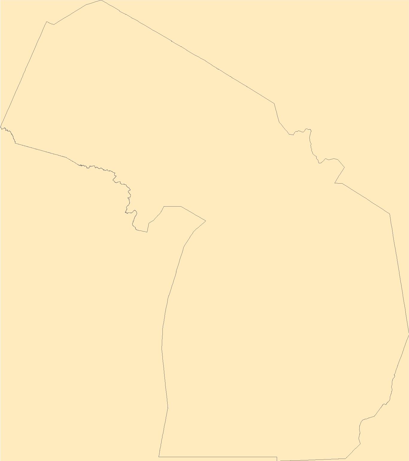
The Geographic Names Information System (GNIS) is the Federal standard for geographic nomenclature. The U.S. Geological Survey developed the GNIS for the U.S. Board on Geographic Names, a Federal inter-agency body chartered by public law to maintain uniform feature name usage throughout the Government and to promulgate standard names to the public. The GNIS is the official repository of domestic geographic names data; the official vehicle for geographic names use by all departments of the Federal Government; and the source for applying geographic names to Federal electronic and printed products of all types.
Tags: Androscoggin,
Antarctica,
Antarctica,
Aroostook,
BGN, All tags...
Board on Geographic Names,
Borough,
Census Area,
Commonwealth,
County,
Cumberland,
District,
Downloadable Data,
Feature class,
Feature coordinates,
Feature county,
Feature description,
Feature designation,
Feature history,
Feature indentification,
Feature name,
Feature state,
Franklin,
GNIS,
GeoPackage,
Geographic Names,
Geographic Names Full Model,
Geographic Names Information System,
Geographic feature,
Geographic name,
Geographical feature,
Geographical name,
Hancock,
Kennebec,
Knox,
Lincoln,
ME,
Maine,
Municipio,
National Geographic Names Information System (GNIS),
National Geographic Names Information System (GNIS),
Official feature name,
Open Geospatial Consortium GeoPackage 1.2,
Outlying Area,
Oxford,
Parish,
Penobscot,
Piscataquis,
Place name,
Populated Place,
Sagadahoc,
Somerset,
State,
Territories,
Territory,
Topographic Map,
U.S. Board on Geographic Names,
U.S. Geological Survey,
US,
USA,
USBGN,
USGS,
United States,
United States,
United States,
Variant name,
Waldo,
Washington,
York,
antarctic,
database,
economy,
environment,
feature,
gazetteer,
geographic,
geographic names,
geographical,
geography,
geospatial,
imageryBaseMapsEarthCover,
inlandWaters,
location,
map,
name,
place,
placename,
society,
structure,
topographic map,
toponymy, Fewer tags

This coverage includes lines that describe sea depths on Bay of Bengal.
Categories: Data;
Types: Downloadable,
Map Service,
OGC WFS Layer,
OGC WMS Layer,
Shapefile;
Tags: Bangladesh,
Digital geologic map,
Earth Science,
Ganges-Brahmaputra Delta, Province 8047,
Geology, All tags...
Jalangi-Sylhet/Burdwan Composite, Total Petroleum System 804702,
Jenam/Bhuban-Bokabil, Total Petroleum System 804703,
Natural Gas,
Oil,
Permian Coal, Total Petroleum System 804701,
Petroleum,
Resource Assessment,
South Asia,
South Asia, Region 8,
Tertiary Composite Total Petroleum System,
U.S. Geological Survey,
USGS,
USGS Science Data Catalog (SDC),
bangladesh,
banthymetry,
geography,
geoscientificInformation,
oilgas,
wep,
worldgeologicmaps, Fewer tags
These tabular data are summaries of natural environment related variables within catchments of the Chesapeake Bay watershed using the Xstrm methodology at 1:24,000 scale. Variables being counted as natural environment related include topography, soils/geology, hydrology/geomorphology, and other physical aspects of surface waters (temperature, flow, etc.). Outputs consist of tabular comma-separated values files (CSVs) for the local catchment linked to the National Hydrography Dataset Plus High-Resolution (NHDPlus HR) framework by NHDPlus ID. Local catchments are defined as the single catchment the data is summarized within. The summarized data tables are structured as a single column representing the catchment id...
Categories: Data;
Tags: Aquatic Biology,
Chesapeake Bay,
Delaware,
District of Columbia,
Ecology, All tags...
Ecology,
Geography,
Geography,
Hydrology,
Hydrology,
Hydrology,
Lower Chesapeake Bay,
Maryland,
New York,
Pennsylvania,
Remote Sensing,
Remote Sensing,
Soil Sciences,
Soil Sciences,
USGS Science Data Catalog (SDC),
Upper Chesapeake Bay,
Virginia,
Water Resources,
Water Resources,
West Virginia,
geographic information systems,
geoscientificInformation,
geospatial datasets,
hydrographic datasets,
inlandWaters,
lithology,
soils,
topography, Fewer tags

Ecosystems benefit people in many ways, but these contributions do not appear in traditional national or corporate accounts so are often left out of policy- and decision-making. Ecosystem accounts, as formalized by the System of Environmental-Economic Accounting Experimental Ecosystem Accounts (SEEA EEA), track the extent and condition of ecosystem assets and the flows of ecosystem services they provide to people and the economy. While ecosystem accounts have been compiled in a number of countries, there have been few attempts to develop them for the United States. We explore the potential for ecosystem accounting in the United States by compiling ecosystem condition and ecosystem services supply and use accounts...
Categories: Data Release - Revised;
Types: Map Service,
OGC WFS Layer,
OGC WMS Layer,
OGC WMS Service;
Tags: Alabama,
Arkansas,
Ecology,
Environmental Health,
Florida, All tags...
Forestry,
Geography,
Georgia,
Hydrology,
Land Use Change,
Louisiana,
Mississippi,
Missouri,
North Carolina,
Soil Sciences,
South Carolina,
Tennessee,
USGS Science Data Catalog (SDC),
Water Quality,
Water Resources,
contamination and pollution,
freshwater ecosystems,
natural resource management,
runoff,
water resources, Fewer tags

The U.S. Geological Survey (USGS) has a long history of working cooperatively with the South Carolina Department of Transportation to develop methods for estimating the magnitude and frequency of floods for rural and urban basins that have minimal to no regulation or tidal influence. As part of those previous investigations, flood-frequency estimates have been generated at selected regulated streamgages. This is the data release for the report which assesses the effects of impoundments on flood-frequency characteristics by comparing annual exceedance probability (AEP) streamflows from pre- and post-regulated (before and after impoundment) periods at 18 USGS long-term streamgages, which is defined as a streamgage...
Tags: Georgia,
North Carolina,
South Carolina,
USGS Science Data Catalog (SDC),
United States, All tags...
Virginia,
Water Resources,
basin,
climatologyMeteorologyAtmosphere,
ecology,
flood,
flood frequency,
floods,
geography,
geoscientificInformation,
hazard preparedness,
hydrology,
inlandWaters,
natural resources,
streamflow,
streamgage,
surface water, Fewer tags

U.S. Geological Survey (USGS) scientists conducted field data collection efforts between July 19th and 31st, 2021 over a large stretch of the McKenzie River in Oregon using high accuracy surveying technologies. The work was initiated as an effort to validate commercially acquired topobathymetric light detection and ranging (lidar) data that was collected coincidentally between July 26th and 30th, 2021 for the USGS 3D Elevation Program (3DEP). The goal was to compare and validate the airborne lidar data to topographic, bathymetric, structural, and infrastructural data collected through more traditional means (e.g., Global Navigational Satellite System (GNSS) surveying). Evaluating these data will provide valuable...
Tags: 3D Elevation Program,
3DEP,
ALS,
Airborne Lidar,
Airborne Topobathymetric Lidar, All tags...
Armitage Park,
Deerhorn County Park,
EWEB Goodpasture Boat Landing,
EWEB Water Board Park,
Eugene,
Finn Rock Boat Landing,
GBL,
GNSS,
Geography,
Geomorphology,
Global Navigation Satellite System,
Ground Based Lidar,
Hayden Bridge Park,
Hendricks Bridge Park,
Hydrology,
Leaburg Dam,
Leaburg Hatchery,
Lidar,
Light Detection and Ranging,
Lloyd Knox Park,
McKenzie High School,
McKenzie River,
NGP Inland Bathymetry Research,
National Geospatial Program,
Old McKenzie Fish Hatchery County Park,
Remote Sensing,
Springfield,
State of Oregon,
TLS,
Terrestrial Laser Scanning,
Topobathy,
Topobathymetric Lidar,
Topobathymetry,
Topographic,
Total Station,
U.S. Geological Survey,
USGS,
USGS Science Data Catalog (SDC),
elevation,
geoscientificInformation,
inlandWaters,
location, Fewer tags

The lateral blast, debris avalanche, and lahars of the May 18th, 1980, eruption of Mount St. Helens, Washington, dramatically altered the surrounding landscape. Lava domes were extruded during the subsequent eruptive periods of 1980-1986 and 2004-2008. During 2022, U.S. Army Corps of Engineers contracted the acquisitions of airborne lidar surveys of Mount St. Helens crater and two primary drainages–upper North Fork Toutle River and South Fork Toutle River with GeoTerra, Inc. The U.S. Geological Survey generated a terrain dataset from the classified point cloud with supplied breaklines and modified lake hydro-flattening, then exported a single digital elevation model (DEM) of the ground surface (that is, 'bare earth'),...
Tags: Climatology,
Ecology,
Forestry,
Geography,
Geomorphology, All tags...
Geophysics,
Glaciology,
Hydrology,
Land Use Change,
Remote Sensing,
Sedimentology,
Soil Sciences,
USGS Science Data Catalog (SDC),
Volcanology,
Water Quality,
Wildlife Biology, Fewer tags

A dataset comprised of road centerlines in Wyoming, USA, digitized to 2015 aerial photography from the National Agriculture Imagery Program. This dataset is an update to a former U.S. Geological Survey Data Series (“Large scale Wyoming transportation data: a resource planning tool”: O'Donnell and others, 2014) digitized to 2009 aerial photography. The U.S. Geological Survey Fort Collins Science Center created statewide roads data for the Bureau of Land Management Wyoming State Office using 2015 aerial photography from the National Agriculture Imagery Program. To ensure a systematic and repeatable approach of capturing roads on the landscape using on-screen digitizing from true color National Agriculture Imagery...
Tags: County roads,
Geography,
Highways,
Interstates,
Remote Sensing, All tags...
Roads,
State highways,
Transportation,
Two track,
USGS Science Data Catalog (SDC),
United States,
Wyoming,
geoscientificInformation, Fewer tags

Unmanned aerial systems (UAS) were used to acquire high-resolution imagery of the Liberty Island Conservation Bank Wildlands restoration site in the Sacramento–San Joaquin Delta in California, with the goal of using structure-from-motion (SfM) photogrammetric techniques to derive a digital surface model, orthomosaic imagery, and a topographic point cloud. The survey was conducted using two Department of Interior-owned 3DR Solo quadcopters fitted with Ricoh GR II digital cameras featuring global shutters. The UAS were flown on pre-programmed autonomous flight lines at an approximate altitude of 120 meters above ground level. The flight lines were oriented roughly east-west and were spaced to provide approximately...
|
|

