Filters: Tags: Graham County (X)
817 results (48ms)|
Filters
Date Range
Types Contacts
Categories Tag Types
|
ADMMR map collection: Arizona Geologic Cross Section Along Line A-B of Plate II; 1 in. to 200 feet; 21 x 6 in.
Categories: Data;
Tags: Aravaipa Mining Corp.,
Arizona,
Arizona,
Cobre Grande Mtn - 7.5 Min,
Dataset,
Heinrichs Geoexploration Co. Maps: San Juan Geologic Sections, Lines 7 to 12; 28 x 58 in.
Heinrichs Geoexploration Co. Maps: Safford Property Map; 1 in. to 1000 feet; 24 x 19 in.
Heinrichs Geoexploration Co. Maps: Safford, Apparent Polarization, Line G, 0.1 and 1.0 CPS; 1 in. to 2000 feet; 14 x 9 in.
Heinrichs Geoexploration Co. Maps: Geologic Drill Hole Section A-A'; 1 in. to 500 feet; 17 x 13 in.
Heinrichs Geoexploration Co. Maps: Safford, Apparent Polarization, Line K, 0.1 and 1.0 CPS; 1 in. to 2000 feet; 13 x 11 in.
Heinrichs Geoexploration Co. Maps: Safford Claim Map; 1 in. to 2000 feet; 16 x 19 in.
Heinrichs Geoexploration Co. Maps: San Simon, Magnetic Interpretation; 1:125000; 36 x 41 in.
Heinrichs Geoexploration Co. Maps: Safford, Alteration-Mineralization; 1 in. to 500 feet; 47 x 42 in.
Heinrichs Geoexploration Co. Maps: Safford, Magnetic Interpretation; 1:125000; 43 x 24 in.
Heinrichs Geoexploration Co. Maps: Winkler-Faulkner, Magnetic Susceptibility Log Drill Hole 6 Core; 8 x 11 in.
Heinrichs Geoexploration Co. Maps: Safford Resistivity; 1 in. to 1000 feet; 28 x 22 in.
The 'Safford Project Kennecott Land Exchange' file is part of the Grover Heinrichs mining collection. Grover was the Vice President of Heinrichs GEOEXploration, located in Tucson, Arizona. The collection contains over 1,400 folders including economic geology reports, maps, photos, correspondence, drill logs and other related materials. The focus of much of the information is on the western United States, particularly Arizona, but the collection also includes files on mining activity throughout the United States, foreign countries, and 82 mineral commodities.

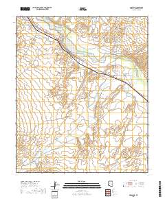
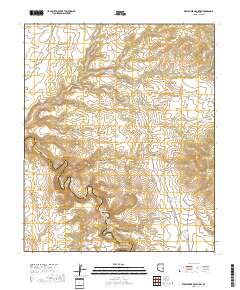
Layered geospatial PDF 7.5 Minute Quadrangle Map. Layers of geospatial data include orthoimagery, roads, grids, geographic names, elevation contours, hydrography, and other selected map features. This map is derived from GIS (geospatial information system) data. It represents a repackaging of GIS data in traditional map form, not creation of new information. The geospatial data in this map are from selected National Map data holdings and other government sources.
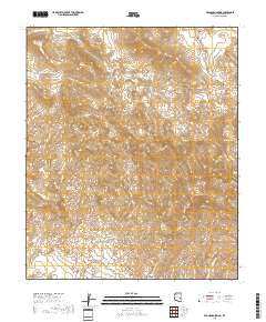
Layered geospatial PDF 7.5 Minute Quadrangle Map. Layers of geospatial data include orthoimagery, roads, grids, geographic names, elevation contours, hydrography, and other selected map features. This map is derived from GIS (geospatial information system) data. It represents a repackaging of GIS data in traditional map form, not creation of new information. The geospatial data in this map are from selected National Map data holdings and other government sources.
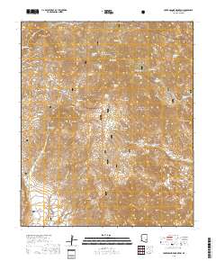
Layered geospatial PDF 7.5 Minute Quadrangle Map. Layers of geospatial data include orthoimagery, roads, grids, geographic names, elevation contours, hydrography, and other selected map features. This map is derived from GIS (geospatial information system) data. It represents a repackaging of GIS data in traditional map form, not creation of new information. The geospatial data in this map are from selected National Map data holdings and other government sources.
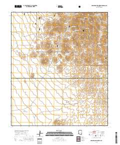
Layered geospatial PDF 7.5 Minute Quadrangle Map. Layers of geospatial data include orthoimagery, roads, grids, geographic names, elevation contours, hydrography, and other selected map features. This map is derived from GIS (geospatial information system) data. It represents a repackaging of GIS data in traditional map form, not creation of new information. The geospatial data in this map are from selected National Map data holdings and other government sources.

Layered geospatial PDF 7.5 Minute Quadrangle Map. Layers of geospatial data include orthoimagery, roads, grids, geographic names, elevation contours, hydrography, and other selected map features. This map is derived from GIS (geospatial information system) data. It represents a repackaging of GIS data in traditional map form, not creation of new information. The geospatial data in this map are from selected National Map data holdings and other government sources.
Layered geospatial PDF 7.5 Minute Quadrangle Map. Layers of geospatial data include orthoimagery, roads, grids, geographic names, elevation contours, hydrography, and other selected map features. This map is derived from GIS (geospatial information system) data. It represents a repackaging of GIS data in traditional map form, not creation of new information. The geospatial data in this map are from selected National Map data holdings and other government sources.
Layered geospatial PDF 7.5 Minute Quadrangle Map. Layers of geospatial data include orthoimagery, roads, grids, geographic names, elevation contours, hydrography, and other selected map features. This map is derived from GIS (geospatial information system) data. It represents a repackaging of GIS data in traditional map form, not creation of new information. The geospatial data in this map are from selected National Map data holdings and other government sources.
|

|
