Filters: Tags: Ground Water (X)
345 results (14ms)|
Filters
Date Range
Extensions Types Contacts
Categories Tag Types
|
These data were released prior to the October 1, 2016 effective date for the USGS’s policy dictating the review, approval, and release of scientific data as referenced in USGS Survey Manual Chapter 502.8 Fundamental Science Practices: Review and Approval of Scientific Data for Release. This dataset is one of eight datasets produced by this study. Four of the datasets predict the probability of detecting atrazine and(or) desethyl-atrazine (a breakdown product of atrazine) in ground water in Colorado; the other four predict the probability of detecting elevated concentrations of nitrate in ground water in Colorado. The four datasets that predict the probability of atrazine and(or) desethyl-atrazine (atrazine/DEA)...
These data were released prior to the October 1, 2016 effective date for the USGS’s policy dictating the review, approval, and release of scientific data as referenced in USGS Survey Manual Chapter 502.8 Fundamental Science Practices: Review and Approval of Scientific Data for Release. This dataset is one of eight datasets produced by this study. Four of the datasets predict the probability of detecting atrazine and(or) desethyl-atrazine (a breakdown product of atrazine) in ground water in Colorado; the other four predict the probability of detecting elevated concentrations of nitrate in ground water in Colorado. The four datasets that predict the probability of atrazine and(or) desethyl-atrazine (atrazine/DEA)...
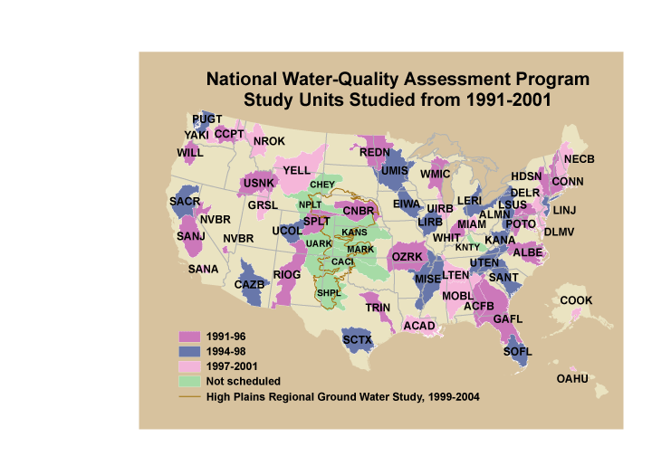
These data were released prior to the October 1, 2016 effective date for the USGS’s policy dictating the review, approval, and release of scientific data as referenced in USGS Survey Manual Chapter 502.8 Fundamental Science Practices: Review and Approval of Scientific Data for Release. This is a GENERALIZED version of the boundaries and codes used for the U.S. Geological Survey's National Water-Quality Assessment (NAWQA) Program Study-Unit investigations in the conterminous United States, excluding the High Plains Regional Ground-Water Study. The data set represents the areas studied during the first decade of the NAWQA Program, from 1991-2001 ("cycle 1"). The coverage is intended only for drawing ILLUSTRATIONS,...

These data were released prior to the October 1, 2016 effective date for the USGS’s policy dictating the review, approval, and release of scientific data as referenced in USGS Survey Manual Chapter 502.8 Fundamental Science Practices: Review and Approval of Scientific Data for Release. This digital data set defines the flow-system boundary encompassing the regional ground-water flow model by D'Agnese and others (1997). The boundary encompasses an approximately 50,000 square-kilometer region of southern Nevada and California, defined as the Death Valley region by Bedinger and others (1989; see Source Citation Information). The flow-system boundary is mostly a no-flow boundary resulting from physical barriers or...

These data were released prior to the October 1, 2016 effective date for the USGS’s policy dictating the review, approval, and release of scientific data as referenced in USGS Survey Manual Chapter 502.8 Fundamental Science Practices: Review and Approval of Scientific Data for Release. This data set represents the presence or absence of semiconsolidated sand aquifers in the conterminous United States. The data set was used as an input data layer for a national model to predict nitrate concentration in ground water used for drinking. Nolan and Hitt (2006) developed two national models to predict contamination of ground water by nonpoint sources of nitrate. The nonlinear approach to national-scale Ground-WAter Vulnerability...

These data were released prior to the October 1, 2016 effective date for the USGS’s policy dictating the review, approval, and release of scientific data as referenced in USGS Survey Manual Chapter 502.8 Fundamental Science Practices: Review and Approval of Scientific Data for Release. This data set consists of digitized water-level elevation contours for the High Plains aquifer in western Oklahoma. This area encompasses the panhandle counties of Cimarron, Texas, and Beaver, and the western counties of Harper, Ellis, Woodward, Dewey, and Roger Mills. The High Plains aquifer underlies approximately 7,000 square miles of Oklahoma and is used extensively for irrigation. The High Plains aquifer is a water-table aquifer...

These data were released prior to the October 1, 2016 effective date for the USGS’s policy dictating the review, approval, and release of scientific data as referenced in USGS Survey Manual Chapter 502.8 Fundamental Science Practices: Review and Approval of Scientific Data for Release. This data set represents the area of National Resources Inventory irrigation system, tailwater recovery conservation practice, in square kilometers, in the conterminous United States. The data set was used as an input data layer for a national model to predict nitrate concentration in ground water used for drinking. Nolan and Hitt (2006) developed two national models to predict contamination of ground water by nonpoint sources of...

These data were released prior to the October 1, 2016 effective date for the USGS’s policy dictating the review, approval, and release of scientific data as referenced in USGS Survey Manual Chapter 502.8 Fundamental Science Practices: Review and Approval of Scientific Data for Release. This data set represents the amount of histosols soil taxonomic order, in percent, in the conterminous United States. The data set was used as an input data layer for a national model to predict nitrate concentration in shallow ground water. Nolan and Hitt (2006) developed two national models to predict contamination of ground water by nonpoint sources of nitrate. The nonlinear approach to national-scale Ground-WAter Vulnerability...

These data were released prior to the October 1, 2016 effective date for the USGS’s policy dictating the review, approval, and release of scientific data as referenced in USGS Survey Manual Chapter 502.8 Fundamental Science Practices: Review and Approval of Scientific Data for Release. This data set represents saturation overland flow estimated by TOPMODEL, in percent of streamflow, in the conterminous United States. The data set was used as an input data layer for a national model to predict nitrate concentration in ground water used for drinking. Nolan and Hitt (2006) developed two national models to predict contamination of ground water by nonpoint sources of nitrate. The nonlinear approach to national-scale...

These data were released prior to the October 1, 2016 effective date for the USGS’s policy dictating the review, approval, and release of scientific data as referenced in USGS Survey Manual Chapter 502.8 Fundamental Science Practices: Review and Approval of Scientific Data for Release. This data set represents "water input," the ratio of the total area of irrigated land to precipitation, in square kilometers per centimeter, in the conterminous United States. The data set was used as an input data layer for a national model to predict nitrate concentration in shallow ground water. Nolan and Hitt (2006) developed two national models to predict contamination of ground water by nonpoint sources of nitrate. The nonlinear...

These data were released prior to the October 1, 2016 effective date for the USGS’s policy dictating the review, approval, and release of scientific data as referenced in USGS Survey Manual Chapter 502.8 Fundamental Science Practices: Review and Approval of Scientific Data for Release. This data set represents 1990 block group population density, in people per square kilometer, in the conterminous United States. The data set was used as an input data layer for a national model to predict nitrate concentration in shallow ground water. Nolan and Hitt (2006) developed two national models to predict contamination of ground water by nonpoint sources of nitrate. The nonlinear approach to national-scale Ground-WAter Vulnerability...

These data were released prior to the October 1, 2016 effective date for the USGS’s policy dictating the review, approval, and release of scientific data as referenced in USGS Survey Manual Chapter 502.8 Fundamental Science Practices: Review and Approval of Scientific Data for Release. This data set represents the average annual nitrogen input from confined animal manure, 1992 and 1997, in kilograms per hectare, in the conterminous United States. The data set was used as an input data layer for a national model to predict nitrate concentration in ground water used for drinking. Nolan and Hitt (2006) developed two national models to predict contamination of ground water by nonpoint sources of nitrate. The nonlinear...

These data were released prior to the October 1, 2016 effective date for the USGS’s policy dictating the review, approval, and release of scientific data as referenced in USGS Survey Manual Chapter 502.8 Fundamental Science Practices: Review and Approval of Scientific Data for Release. This raster data set represents water-level change in the High Plains aquifer of the United States from 2000 to 2005, in feet. The High Plains aquifer underlies 112.6 million acres (176,000 square miles) in parts of eight States: Colorado, Kansas, Nebraska, New Mexico, Oklahoma, South Dakota, Texas, and Wyoming. Water-level declines occurred in parts of the High Plains aquifer soon after the onset of substantial irrigation with groundwater...

These data were released prior to the October 1, 2016 effective date for the USGS’s policy dictating the review, approval, and release of scientific data as referenced in USGS Survey Manual Chapter 502.8 Fundamental Science Practices: Review and Approval of Scientific Data for Release. This digital data set defines the lateral boundary of the area simulated by the steady-state ground-water flow model of the Death Valley regional ground-water flow system (DVRFS) by D'Agnese and others (2002). The DVRFS flow model was developed by the U.S. Geological Survey (USGS) for the U.S. Department of Energy (DOE) to support investigations at the Nevada Test Site (NTS) and at Yucca Mountain, Nevada. The model area is an approximately...
A potentiometric surface map for spring 2016 was created for the Mississippi River Valley alluvial (MRVA) aquifer, which was referenced to the North American Vertical Datum of 1988 (NAVD 88), using most of the available groundwater-altitude data from wells and surface-water-altitude data from streamgages. Most of the wells were measured annually or one time, after installation, but some wells were measured more than one time in a year and a small number of wells were measured continually. Streamgages were typically operated continuously. The potentiometric surface map for 2016 was created as part of the U.S. Geological Survey (USGS) Water Availability and Use Science Program to support investigations that characterize...
Between 1979 and 1982, the Alaska Division of Geological & Geophysical Surveys (DGGS) and the Geophysical Institute, University of Alaska Fairbanks, undertook an assessment of the states geothermal resources under a program jointly sponsored by the U.S. Department of Energy and the State of Alaska. During this period, reconnaissance investigations of more than 100 thermal spring sites and fumarole fields located in Alaska were conducted by DGGS.

Springs are naturally occurring features that convey excess ground water to the land surface; they represent a transition from ground water to surface water. Water issues through one opening, multiple openings, or numerous seeps in the rock or soil. This dataset provides information about springs in Texas including spring names, identification numbers, location, and, if available, water source and use. This dataset does not include every spring in Texas, but is limited to an aggregation of selected digital and hard-copy data of the Texas Water Development Board, the U.S. Geological Survey, and Capitol Environmental Services.
Riverine riparian vegetation has changed throughout the southwestern United States, prompting concern about losses of habitat and biodiversity. Woody riparian vegetation grows in a variety of geomorphic settings ranging from bedrock-lined channels to perennial streams crossing deep alluvium and is dependent on interaction between ground-water and surface-water resources. Historically, few reaches in Arizona, southern Utah, or eastern California below 1530 m elevation had closed gallery forests of cottonwood and willow; instead, many alluvial reaches that now support riparian gallery forests once had marshy grasslands and most bedrock canyons were essentially barren. Repeat photography using more than 3000 historical...
Categories: Publication;
Types: Citation;
Tags: Channel change,
Floods,
Ground water,
Surface water,
geomorphology,

These data were released prior to the October 1, 2016 effective date for the USGS’s policy dictating the review, approval, and release of scientific data as referenced in USGS Survey Manual Chapter 502.8 Fundamental Science Practices: Review and Approval of Scientific Data for Release. This digital dataset defines the surface traces of regional features simulated as horizontal flow barriers in the Death Valley regional ground-water flow system (DVRFS) transient flow model, an approximately 45,000 square-kilometer area of southern Nevada and California. The DVRFS transient groundwater flow model is one of several regional-scale models developed by the U.S. Geological Survey (USGS) for the U.S. Department of Energy...

These data were released prior to the October 1, 2016 effective date for the USGS’s policy dictating the review, approval, and release of scientific data as referenced in USGS Survey Manual Chapter 502.8 Fundamental Science Practices: Review and Approval of Scientific Data for Release. This digital data set defines the boundary of the hydrogeologic framework model (HFM) developed by IT Corporation (1996) for the U.S. Department of Energy Underground Test Area Phase I project. The boundary encompasses an approximate 53,000 square-kilometer region which is centered on the Nevada Test Site (NTS) and extends from Death Valley to east of the East Pahranagat Range, and from the Black Mountains to north of Penoyer and...
|

|
