Filters: Tags: Hydrology (X) > Types: Citation (X)
190 results (147ms)|
Filters
Date Range
Extensions Types Contacts
Categories Tag Types
|

This geodatabase contains streams, waterbodies and wetlands, streamflow gaging stations, and coastlines for the United States, Puerto Rico, and the U.S. Virgin Islands. The streams are incorporated into a geometric network. All feature classes are vertically integrated with each other and with 1:1,000,000-scale transportation and boundary data sets.
This dataset is the result of measurements of groundwater levels in the Equus Beds aquifer near Wichita, Kansas, in January 2016. Potentiometric surfaces are interpolated for the shallow and deep parts of the aquifer, and rasters of the potentiometric surfaces are included in this data release. Wells were classified as being screened in the shallow or deep parts of the aquifer based on station name (some wells have a layer identifier in the station name) or, if no indication of aquifer layer was given in the station name, based on the depth of the well; wells with depths less than 80 feet below land surface were classified as shallow and wells with depths of 80 feet or deeper were classified as deep. Contours with...
Categories: Data;
Types: Citation,
Downloadable,
Map Service,
OGC WFS Layer,
OGC WMS Layer,
Shapefile;
Tags: Arkansas River,
Bentley,
Burrton,
Equus Beds aquifer,
Halstead,
The U.S. Geological Survey (USGS) assisted the Massachusetts Department of Environmental Protection (MassDEP) with the Massachusetts Estuary Project (MEP), by delineating groundwater-contributing areas to various hydrologic features including ponds, streams, and coastal water bodies, throughout southeastern Massachusetts. These contributing areas were delineated over a 6-year period from 2003 to 2008 using previously published USGS groundwater-flow models for the Plymouth-Carver region (Masterson and others, 2009), the Sagamore (western) and Monomoy (eastern) flow lenses of Cape Cod (Walter and Whealan, 2005), and lower Cape Cod (Masterson, 2004). The original USGS groundwater-contributing areas were subsequently...
For the Minute 319 pulse flow, electromagnetic induction surveys were carried out jointly by the USGS and UABC-CICESE. Measurements were made at 5 m intervals and transect lengths ranged from 55 m to 200 m.
Categories: Data;
Types: Citation,
Downloadable,
Map Service,
OGC WFS Layer,
OGC WMS Layer,
Shapefile;
Tags: Colorado River Delta,
Geophysics,
Hydrology
The influence of woody vegetation and biological soil crusts on infiltration capacity is one of the several uncertainties associated with the ecohydrologic effects of woody plant encroachment into arid and semi-arid land systems. The objective of this study was to quantify the effects of Utah juniper (Juniperus osteosperma) and pinyon pine (Pinus edulis) on subcanopy and intercanopy ecohydrologic properties. We measured soil sorptivity, unsaturated hydraulic conductivity [K(h)], soil water content (SWC), and water repellency along radial line transects from under Juniperus and Pinus trees into the centre of the intercanopy space between trees. In the subcanopy, litter mounds, hydrophobic soils, and roots all appear...
Categories: Publication;
Types: Citation,
Journal Citation;
Tags: Ecohydrology,
biological soil crust,
hydrology,
juniper,
pinyon,
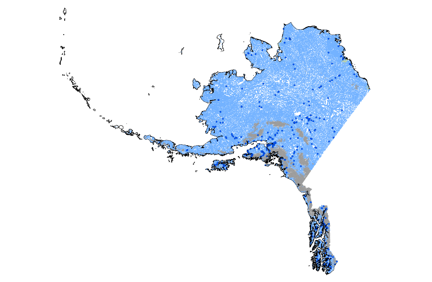
This geodatabase contains streams, waterbodies and wetlands, streamflow gaging stations, and coastlines for Alaska. The streams are incorporated into a geometric network. All feature classes are vertically integrated with each other and with 1:1,000,000-scale transportation and boundary data sets.
The hydrology and geomorphology of large rivers in America reflect the pervasive influence of an extensive water control infrastructure including more than 75,000 dams. One hundred thirty-seven of the very large dams, each storing 1.2 km3 (106 acre feet) of water or more, alter the flows of every large river in the country. The hydrologic effects of these very large dams emerge from an analysis of the stream gage records of 72 river reaches organized into 36 pairs. One member of each pair is an unregulated reach above a dam, whereas the other is a regulated reach downstream from the same structure. Comparison of the regulated and unregulated reaches shows that very large dams, on average, reduce annual peak discharges...
Categories: Publication;
Types: Citation,
Journal Citation;
Tags: Geomorphology,
aquatic and riparian habitats,
dams,
fluvial geomorphology,
hydrology,
Depth-to-water data in the San Joaquin Valley, CA were collected in 1910 and published in Mendenhall and others, 1916. These data were used to create a depth-to-water contour of the Valley described in Plate 1 entitled "Map of San Joaquin Valley, California showing artesian areas, ground-water levels and location of pumping plants", which includes a depiction of geographical areas where flowing well (artesian) conditions existed in 1910. These "Areas of flowing wells" have been converted into a digital vector format (ArcGIS Shapefile) for use in future research.
Types: Citation,
Map Service,
OGC WFS Layer,
OGC WMS Layer,
OGC WMS Service;
Tags: Agriculture,
Artesian,
California,
Central Valley, California,
Environment,
This dataset contains water chemistry measurements for groundwater wells in the Cottonwood Lake Study Area, Stutsman County, North Dakota.
Categories: Data;
Types: Citation;
Tags: Biochemical analysis,
Biogeochemical cylcing,
Biogeochemistry,
Chemical analysis,
Climatic change,
The U.S. Geological Survey (USGS) is providing an online map of stream and lake gage water level measurements on Long Island, New York, April-May 2013. USGS serves this map and geospatial data as a REST Open Map Service (as well as HTTP, JSON, KML, and shapefile), so end-users can use the map and data on mobile and web clients. A companion report, U.S. Geological Survey Scientific Investigations Map 3326 (Como and others, 2015; http://dx.doi.org/10.3133/sim3326) further describes data collection and map preparation and presents 68x22 in. PDF versions, 4 sheets, scale 1:125,000. Continuous records of water level altitude at 16 U.S. Geological Survey (USGS) streamgaging stations (15 streams and...
Categories: Data,
Publication;
Types: ArcGIS REST Map Service,
ArcGIS Service Definition,
Citation,
Downloadable,
Map Service;
Tags: Geospatial Applications,
Groundwater,
Hydrology,
Information Visualization,
Levels,
The text file "Air temperature.txt" contains hourly data and associated data-source flag from January 1, 1948, to September 30, 2016. The primary source of the data is the Argonne National Laboratory, Illinois. The data-source flag consist of a three-digit sequence in the form "xyz" that describe the origin and transformations of the data values. They indicate if the data are original or missing, the method that was used to fill the missing periods, and any other transformations of the data. The user of the data should consult Over and others (2010) for the detailed documentation of this hourly data-source flag series. Reference Cited: Over, T.M., Price, T.H., and Ishii, A.L., 2010, Development and analysis of...
The text file "Dewpoint temperature.txt" contains hourly data and associated data-source flag from January 1, 1948, to September 30, 2017. Argonne National Laboratory (Argonne National Laboratory, 2017) is the primary source of the data and is processed following the guidelines documented in Over and others (2010). Missing and apparently erroneous data values were replaced with adjusted values from nearby stations used as “backup”. Midwestern Regional Climate Center (Midwestern Regional Climate Center, 2017) station at Chicago O'Hare International Airport is used as "backup". Each hourly value is assigned a corresponding data source flag that indicates the source of the value and its transformations. Each flag is...
How groundwater flow varies when long-term external conditions change is little documented. Geochemical evidence shows that sea-level rise at the end of the last glacial period led to a shift in the flow patterns of coastal groundwater beneath Florida.
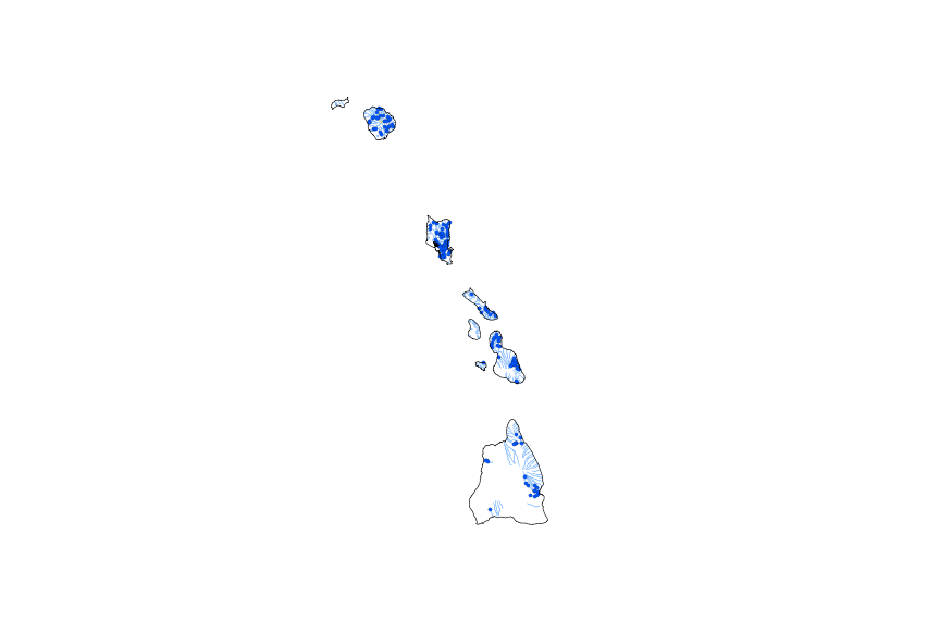
This geodatabase contains streams, waterbodies and wetlands, streamflow gaging stations, and coastlines for Hawaii. The streams are incorporated into a geometric network. All feature classes are vertically integrated with each other and with 1:1,000,000-scale transportation and boundary data sets.
Aim A regional analysis was used to explore the influence of river regulation on the dominance of non-native, invasive shrubs and trees. We addressed the following questions: (1) How do large dams affect hydrological parameters that influence riparian vegetation? (2) How do flow regimes affect the dominance of non-native woody species? (3) How do changes in flow regimes affect the dominance of non-native woody species? Location South-western USA. Methods We sampled the canopy cover of woody species on 179 point bars along seven non-dammed and thirteen dammed river segments. Wilcoxon rank sum tests were used to determine differences between flow parameters in dammed and non-dammed rivers. We used correlation analyses...
Categories: Publication;
Types: Citation,
Journal Citation;
Tags: Dams,
Elaeagnus,
Global Ecology and Biogeography,
Populus,
Salix,
The basis for these features is U.S. Geological Survey Scientific Investigations Report 2017-5024 Flood Inundation Mapping Data for Johnson Creek near Sycamore, Oregon. The domain of the HEC-RAS hydraulic model is a 12.9-mile reach of Johnson Creek from just upstream of SE 174th Avenue in Portland, Oregon, to its confluence with the Willamette River. Some of the hydraulics used in the model were taken from Federal Emergency Management Agency, 2010, Flood Insurance Study, City of Portland, Oregon, Multnomah, Clackamas, and Washington Counties, Volume 1 of 3, November 26, 2010. The Digital Elevation Model (DEM) utilized for the project was developed from lidar data flown in 2015 and provided by the Oregon Department...
Categories: Data;
Types: Citation,
Downloadable,
Map Service,
OGC WFS Layer,
OGC WMS Layer,
Shapefile;
Tags: Johnson Creek,
Portland, Oregon,
Willamette Valley,
digital elevation models,
floods,
Data are raw data files output by the Burris gravimeter PDA. Files include the Earth tide correction used in the UltraGrav software.
Agriculture is the leading source of nonpoint-source pollution on a national scale. the driving force of nonpoint-source pollution is the rainfall-runoff process, which is the transformation of rainfall to streamflow. This is a complex, nonlinear, time-varying, and spatially distributed process on the watershed scale that is difficult to effectively model by conventional, deterministic means. Artificial neural networks (ANNs) offer a new approach to forecasting the hydrologic and water quality response of a watershed system. The goal of this work is to develop an ANN model as a long-term forecuating tool for predicting the hydrology and water quality of agricultural watersheds where the physical processes are difficult...
Categories: Publication;
Types: Citation;
Tags: Agriculture,
Artificial neural network,
Data Visualization & Tools,
Engineering,
Hydrology,
This recorded presentation is from the April 17, 2014 workshop for the "Integrated Scenarios of the Future Northwest Environment" project. The recording is available on YouTube. The Integrated Scenarios project is an effort to understand and predict the effects of climate change on the Northwest's climate, hydrology, and vegetation. The project was funded by the Northwest Climate Science Center and the Climate Impacts Research Consortium.
Categories: Publication;
Types: Citation;
Tags: Climate,
Data Visualization & Tools,
Northwest CASC,
Northwestern United States,
Science Tools for Managers,
The U.S. Geological Survey (USGS) is providing an online map of water level measurements in the Magothy and Jameco aquifers on Long Island, New York, April-May 2013. USGS serves this map and geospatial data as a REST Open Map Service (as well as HTTP, JSON, KML, and shapefile), so end-users can use the map and data on mobile and web clients. A companion report, U.S. Geological Survey Scientific Investigations Map 3326 (Como and others, 2015; http://dx.doi.org/10.3133/sim3326) further describes data collection and map preparation and presents 68x22 in. PDF versions, 4 sheets, scale 1:125,000. The potentiometric surface altitude was measured at 70 observation wells and 31 supply wells screened...
|

|
