Filters
Date Types (for Date Range)
Contacts
Tag Types
Tag Schemes
|
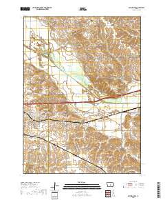
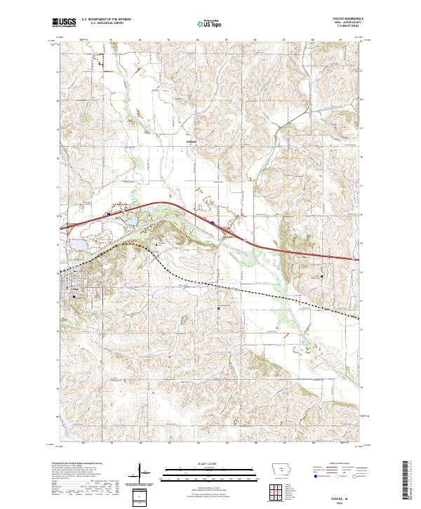
Layered geospatial PDF 7.5 Minute Quadrangle Map. Layers of geospatial data include orthoimagery, roads, grids, geographic names, elevation contours, hydrography, and other selected map features. This map is derived from GIS (geospatial information system) data. It represents a repackaging of GIS data in traditional map form, not creation of new information. The geospatial data in this map are from selected National Map data holdings and other government sources.
Tags: 7.5 x 7.5 minute,
Downloadable Data,
EarthCover,
Geospatial PDF,
Imagery and Base Maps, All tags...
Iowa,
Jasper County,
Map,
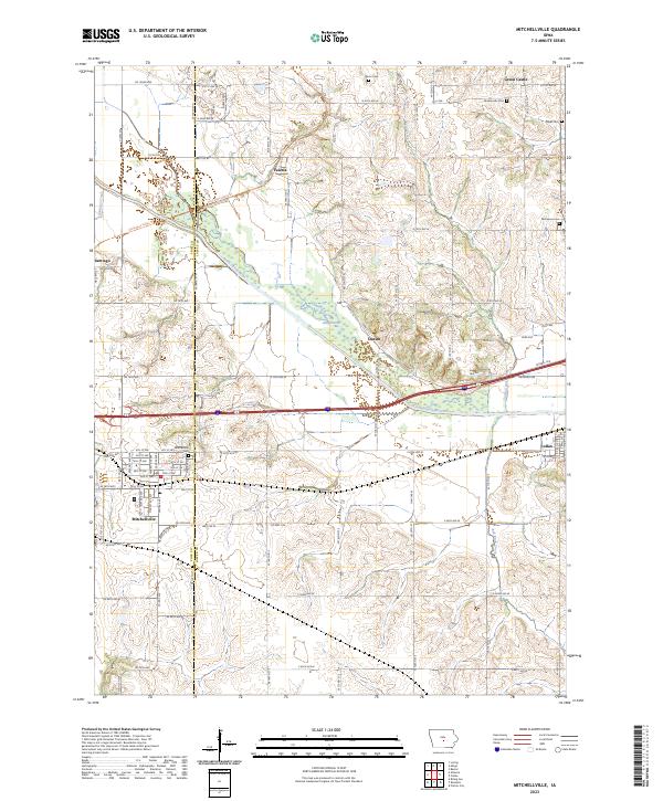
Mitchellville, IA,
Polk County,
Public Land Survey System,
U.S. National Grid,
US,
US Topo,
US Topo Historical,
boundary,
contour,
geographic names,
hydrography,
imageryBaseMapsEarthCover,
orthoimage,
structures,
topographic,
transportation,
woodland, Fewer tags

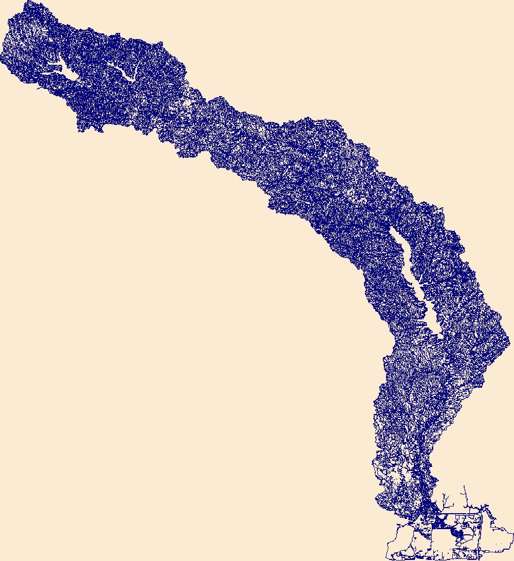
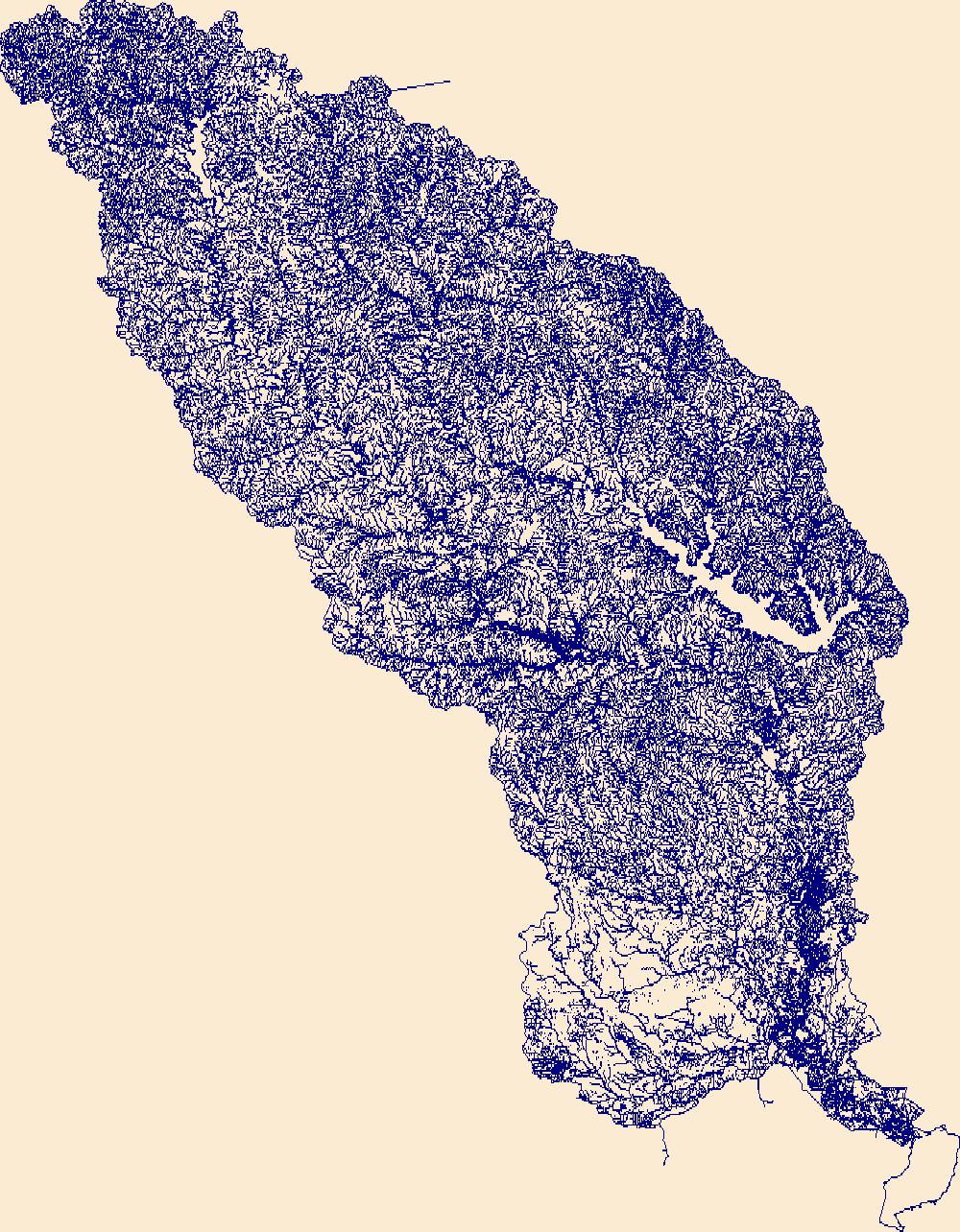
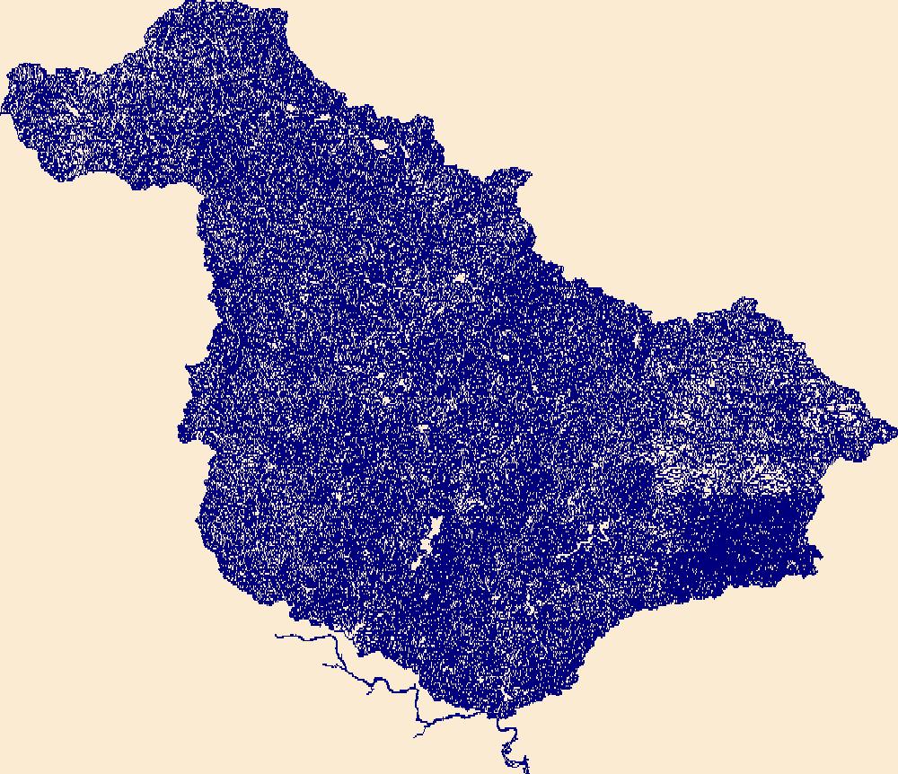
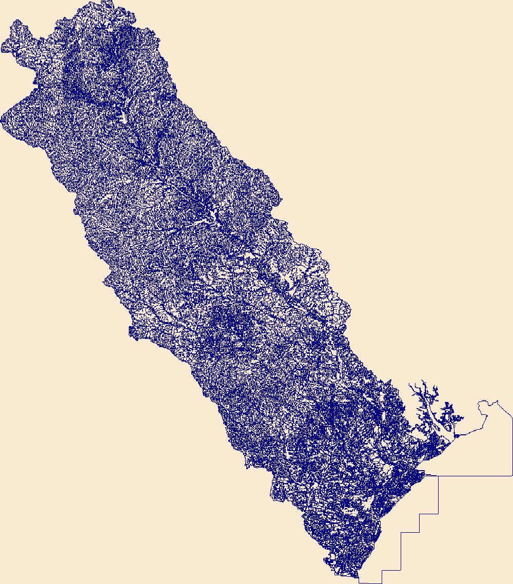
The High Resolution National Hydrography Dataset Plus (NHDPlus HR) is an integrated set of geospatial data layers, including the best available National Hydrography Dataset (NHD), the 10-meter 3D Elevation Program Digital Elevation Model (3DEP DEM), and the National Watershed Boundary Dataset (WBD). The NHDPlus HR combines the NHD, 3DEP DEMs, and WBD to create a stream network with linear referencing, feature naming, "value added attributes" (VAAs), elevation-derived catchments, and other features for hydrologic data analysis. The stream network with linear referencing is a system of data relationships applied to hydrographic systems so that one stream reach "flows" into another and "events" can be tied to and traced...
Tags: Abbeville County,
Aiken County,
Alexander County,
Allendale County,
Anderson County, All tags...
Avery County,
Bamberg County,
Barnwell County,
Beaufort County,
Berkeley County,
Buncombe County,
Burke County,
Caldwell County,
Calhoun County,
Catawba County,
Charleston County,
Cherokee County,
Chester County,
Clarendon County,
Cleveland County,
Colleton County,
Dorchester County,
Downloadable Data,
Edgefield County,
Fairfield County,
FileGDB,
FileGDB 10.1,
Gaston County,
Georgetown County,
Greenville County,
Greenwood County,
HU-4 Subregion,
HU-4 Subregion,
HU4_0305,
Hampton County,
Henderson County,
Hydrography,
Iredell County,
Jasper County,
Kershaw County,
Lancaster County,
Laurens County,
Lee County,
Lexington County,
Lincoln County,
McDowell County,
Mecklenburg County,
Mitchell County,
NC,
NHDPlus HR Rasters,
NHDPlus High Resolution (NHDPlus HR),
National Hydrography Dataset (NHD),
National Hydrography Dataset Plus High Resolution (NHDPlus HR),
National Hydrography Dataset Plus High Resolution (NHDPlus HR) Current,
Newberry County,
North Carolina,
Orangeburg County,
Pickens County,
Polk County,
Richland County,
Rutherford County,
SC,
Saluda County,
South Carolina,
Spartanburg County,
Sumter County,
Transylvania County,
US,
Union County,
Union County,
United States,
Watauga County,
Wilkes County,
Williamsburg County,
Yancey County,
York County,
base maps,
cartography,
catchments,
channels,
digital elevation models,
drainage basins,
earth sciences,
elevation,
environment,
geographic information systems,
geoscientific,
geospatial analysis,
hydrographic datasets,
hydrographic features,
hydrology,
imagery,
inland waters,
lakes,
land surface characteristics,
reservoirs,
river reaches,
rivers,
streamflow,
streamflow data,
streams,
topography,
water bodies,
water quality,
water resources,
watersheds, Fewer tags
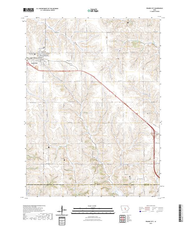
Layered geospatial PDF 7.5 Minute Quadrangle Map. Layers of geospatial data include orthoimagery, roads, grids, geographic names, elevation contours, hydrography, and other selected map features. This map is derived from GIS (geospatial information system) data. It represents a repackaging of GIS data in traditional map form, not creation of new information. The geospatial data in this map are from selected National Map data holdings and other government sources.
Tags: 7.5 x 7.5 minute,
Downloadable Data,
EarthCover,
Geospatial PDF,
Imagery and Base Maps, All tags...
Iowa,
Jasper County,
Map,
Marion County,
Prairie City, IA,
Public Land Survey System,
U.S. National Grid,
US,
US Topo,
US Topo Historical,
boundary,
contour,
geographic names,
hydrography,
imageryBaseMapsEarthCover,
orthoimage,
structures,
topographic,
transportation,
woodland, Fewer tags

The High Resolution National Hydrography Dataset Plus (NHDPlus HR) is an integrated set of geospatial data layers, including the best available National Hydrography Dataset (NHD), the 10-meter 3D Elevation Program Digital Elevation Model (3DEP DEM), and the National Watershed Boundary Dataset (WBD). The NHDPlus HR combines the NHD, 3DEP DEMs, and WBD to create a stream network with linear referencing, feature naming, "value added attributes" (VAAs), elevation-derived catchments, and other features for hydrologic data analysis. The stream network with linear referencing is a system of data relationships applied to hydrographic systems so that one stream reach "flows" into another and "events" can be tied to and traced...
Tags: Appling County,
Atkinson County,
Bacon County,
Baker County,
Baldwin County, All tags...
Banks County,
Barrow County,
Ben Hill County,
Bibb County,
Bleckley County,
Brantley County,
Butts County,
Camden County,
Candler County,
Charlton County,
Clarke County,
Clayton County,
Clinch County,
Coffee County,
Columbia County,
Crawford County,
DeKalb County,
Dodge County,
Dooly County,
Downloadable Data,
Duval County,
Emanuel County,
Evans County,
FL,
FileGDB,
FileGDB 10.1,
Florida,
Fulton County,
GA,
Georgia,
Glynn County,
Greene County,
Gwinnett County,
HU-4 Subregion,
HU-4 Subregion,
HU4_0307,
Hall County,
Hancock County,
Henry County,
Houston County,
Hydrography,
Irwin County,
Jackson County,
Jasper County,
Jeff Davis County,
Jefferson County,
Johnson County,
Jones County,
Lamar County,
Laurens County,
Liberty County,
Long County,
Macon County,
Madison County,
McIntosh County,
Monroe County,
Montgomery County,
Morgan County,
NHDPlus HR Rasters,
NHDPlus High Resolution (NHDPlus HR),
Nassau County,
National Hydrography Dataset (NHD),
National Hydrography Dataset Plus High Resolution (NHDPlus HR),
National Hydrography Dataset Plus High Resolution (NHDPlus HR) Current,
Newton County,
Oconee County,
Oglethorpe County,
Peach County,
Pierce County,
Pulaski County,
Putnam County,
Rockdale County,
Spalding County,
Taliaferro County,
Tattnall County,
Telfair County,
Toombs County,
Treutlen County,
Twiggs County,
US,
Union County,
United States,
Upson County,
Walton County,
Ware County,
Washington County,
Wayne County,
Wheeler County,
Wilcox County,
Wilkinson County,
base maps,
cartography,
catchments,
channels,
digital elevation models,
drainage basins,
earth sciences,
elevation,
environment,
geographic information systems,
geoscientific,
geospatial analysis,
hydrographic datasets,
hydrographic features,
hydrology,
imagery,
inland waters,
lakes,
land surface characteristics,
reservoirs,
river reaches,
rivers,
streamflow,
streamflow data,
streams,
topography,
water bodies,
water quality,
water resources,
watersheds, Fewer tags
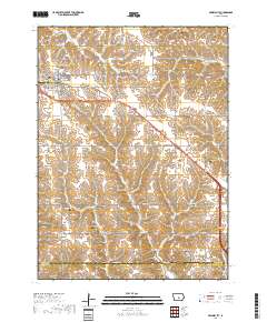
Layered geospatial PDF 7.5 Minute Quadrangle Map. Layers of geospatial data include orthoimagery, roads, grids, geographic names, elevation contours, hydrography, and other selected map features. This map is derived from GIS (geospatial information system) data. It represents a repackaging of GIS data in traditional map form, not creation of new information. The geospatial data in this map are from selected National Map data holdings and other government sources.
Tags: 7.5 x 7.5 minute,
Colfax, IA,
Downloadable Data,
EarthCover,
Geospatial PDF, All tags...
Imagery and Base Maps,
Iowa,
Jasper County,
Map,
Public Land Survey System,
U.S. National Grid,
US,
US Topo,
US Topo Historical,
boundary,
contour,
geographic names,
hydrography,
imageryBaseMapsEarthCover,
orthoimage,
structures,
topographic,
transportation,
woodland, Fewer tags
The High Resolution National Hydrography Dataset Plus (NHDPlus HR) is an integrated set of geospatial data layers, including the best available National Hydrography Dataset (NHD), the 10-meter 3D Elevation Program Digital Elevation Model (3DEP DEM), and the National Watershed Boundary Dataset (WBD). The NHDPlus HR combines the NHD, 3DEP DEMs, and WBD to create a stream network with linear referencing, feature naming, "value added attributes" (VAAs), elevation-derived catchments, and other features for hydrologic data analysis. The stream network with linear referencing is a system of data relationships applied to hydrographic systems so that one stream reach "flows" into another and "events" can be tied to and traced...
Tags: Beauregard County,
Caddo County,
Calcasieu County,
Cameron County,
Collin County, All tags...
De Soto County,
Downloadable Data,
FileGDB,
FileGDB 10.1,
Franklin County,
Gregg County,
HU-4 Subregion,
HU-4 Subregion,
HU4_1201,
Harrison County,
Hopkins County,
Hunt County,
Hydrography,
Jasper County,
Kaufman County,
LA,
Louisiana,
NHDPlus HR Rasters,
NHDPlus High Resolution (NHDPlus HR),
Natchitoches County,
National Hydrography Dataset (NHD),
National Hydrography Dataset Plus High Resolution (NHDPlus HR),
National Hydrography Dataset Plus High Resolution (NHDPlus HR) Current,
Newton County,
Orange County,
Panola County,
Rains County,
Rockwall County,
Rusk County,
Sabine County,
Sabine County,
San Augustine County,
Shelby County,
Smith County,
TX,
Texas,
US,
United States,
Upshur County,
Van Zandt County,
Vernon County,
Wood County,
base maps,
cartography,
catchments,
channels,
digital elevation models,
drainage basins,
earth sciences,
elevation,
environment,
geographic information systems,
geoscientific,
geospatial analysis,
hydrographic datasets,
hydrographic features,
hydrology,
imagery,
inland waters,
lakes,
land surface characteristics,
reservoirs,
river reaches,
rivers,
streamflow,
streamflow data,
streams,
topography,
water bodies,
water quality,
water resources,
watersheds, Fewer tags
The High Resolution National Hydrography Dataset Plus (NHDPlus HR) is an integrated set of geospatial data layers, including the best available National Hydrography Dataset (NHD), the 10-meter 3D Elevation Program Digital Elevation Model (3DEP DEM), and the National Watershed Boundary Dataset (WBD). The NHDPlus HR combines the NHD, 3DEP DEMs, and WBD to create a stream network with linear referencing, feature naming, "value added attributes" (VAAs), elevation-derived catchments, and other features for hydrologic data analysis. The stream network with linear referencing is a system of data relationships applied to hydrographic systems so that one stream reach "flows" into another and "events" can be tied to and traced...
Tags: Anderson County,
Angelina County,
Cherokee County,
Downloadable Data,
FileGDB, All tags...
FileGDB 10.1,
HU-4 Subregion,
HU-4 Subregion,
HU4_1202,
Hardin County,
Henderson County,
Houston County,
Hydrography,
Jasper County,
Jefferson County,
Liberty County,
NHDPlus HR Rasters,
NHDPlus High Resolution (NHDPlus HR),
Nacogdoches County,
National Hydrography Dataset (NHD),
National Hydrography Dataset Plus High Resolution (NHDPlus HR),
National Hydrography Dataset Plus High Resolution (NHDPlus HR) Current,
Newton County,
Orange County,
Polk County,
Rusk County,
Sabine County,
San Augustine County,
Shelby County,
Smith County,
TX,
Texas,
Trinity County,
Tyler County,
US,
United States,
Van Zandt County,
base maps,
cartography,
catchments,
channels,
digital elevation models,
drainage basins,
earth sciences,
elevation,
environment,
geographic information systems,
geoscientific,
geospatial analysis,
hydrographic datasets,
hydrographic features,
hydrology,
imagery,
inland waters,
lakes,
land surface characteristics,
reservoirs,
river reaches,
rivers,
streamflow,
streamflow data,
streams,
topography,
water bodies,
water quality,
water resources,
watersheds, Fewer tags
The High Resolution National Hydrography Dataset Plus (NHDPlus HR) is an integrated set of geospatial data layers, including the best available National Hydrography Dataset (NHD), the 10-meter 3D Elevation Program Digital Elevation Model (3DEP DEM), and the National Watershed Boundary Dataset (WBD). The NHDPlus HR combines the NHD, 3DEP DEMs, and WBD to create a stream network with linear referencing, feature naming, "value added attributes" (VAAs), elevation-derived catchments, and other features for hydrologic data analysis. The stream network with linear referencing is a system of data relationships applied to hydrographic systems so that one stream reach "flows" into another and "events" can be tied to and traced...
Tags: AR,
Allen County,
Anderson County,
Arkansas,
Barry County, All tags...
Barton County,
Benton County,
Bourbon County,
Butler County,
Chase County,
Chautauqua County,
Cherokee County,
Cherokee County,
Christian County,
Coffey County,
Cowley County,
Craig County,
Crawford County,
Dade County,
Delaware County,
Downloadable Data,
Elk County,
FileGDB,
FileGDB 10.1,
Greenwood County,
HU-4 Subregion,
HU-4 Subregion,
HU4_1107,
Harvey County,
Hydrography,
Jasper County,
KS,
Kansas,
Labette County,
Lawrence County,
Lyon County,
MO,
Marion County,
Mayes County,
McDonald County,
McPherson County,
Missouri,
Montgomery County,
Morris County,
Muskogee County,
NHDPlus HR Rasters,
NHDPlus High Resolution (NHDPlus HR),
National Hydrography Dataset (NHD),
National Hydrography Dataset Plus High Resolution (NHDPlus HR),
National Hydrography Dataset Plus High Resolution (NHDPlus HR) Current,
Neosho County,
Newton County,
Nowata County,
OK,
Oklahoma,
Osage County,
Osage County,
Ottawa County,
Rogers County,
Stone County,
Tulsa County,
US,
United States,
Wabaunsee County,
Wagoner County,
Washington County,
Wilson County,
Woodson County,
base maps,
cartography,
catchments,
channels,
digital elevation models,
drainage basins,
earth sciences,
elevation,
environment,
geographic information systems,
geoscientific,
geospatial analysis,
hydrographic datasets,
hydrographic features,
hydrology,
imagery,
inland waters,
lakes,
land surface characteristics,
reservoirs,
river reaches,
rivers,
streamflow,
streamflow data,
streams,
topography,
water bodies,
water quality,
water resources,
watersheds, Fewer tags
Layered geospatial PDF 7.5 Minute Quadrangle Map. Layers of geospatial data include orthoimagery, roads, grids, geographic names, elevation contours, hydrography, and other selected map features. This map is derived from GIS (geospatial information system) data. It represents a repackaging of GIS data in traditional map form, not creation of new information. The geospatial data in this map are from selected National Map data holdings and other government sources.
Tags: 7.5 x 7.5 minute,
Downloadable Data,
EarthCover,
Geospatial PDF,
Imagery and Base Maps, All tags...
Iowa,
Jasper County,
Map,
Public Land Survey System,
U.S. National Grid,
US,
US Topo,
US Topo Current,
boundary,
contour,
geographic names,
hydrography,
imageryBaseMapsEarthCover,
orthoimage,
structures,
topographic,
transportation,
woodland, Fewer tags
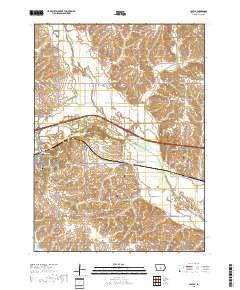
Layered geospatial PDF 7.5 Minute Quadrangle Map. Layers of geospatial data include orthoimagery, roads, grids, geographic names, elevation contours, hydrography, and other selected map features. This map is derived from GIS (geospatial information system) data. It represents a repackaging of GIS data in traditional map form, not creation of new information. The geospatial data in this map are from selected National Map data holdings and other government sources.
Tags: 7.5 x 7.5 minute,
Downloadable Data,
EarthCover,
Geospatial PDF,
Imagery and Base Maps, All tags...
Iowa,
Jasper County,
Map,
Polk County,
Public Land Survey System,
U.S. National Grid,
US,
US Topo,
US Topo Current,
boundary,
contour,
geographic names,
hydrography,
imageryBaseMapsEarthCover,
orthoimage,
structures,
topographic,
transportation,
woodland, Fewer tags

The High Resolution National Hydrography Dataset Plus (NHDPlus HR) is an integrated set of geospatial data layers, including the best available National Hydrography Dataset (NHD), the 10-meter 3D Elevation Program Digital Elevation Model (3DEP DEM), and the National Watershed Boundary Dataset (WBD). The NHDPlus HR combines the NHD, 3DEP DEMs, and WBD to create a stream network with linear referencing, feature naming, "value added attributes" (VAAs), elevation-derived catchments, and other features for hydrologic data analysis. The stream network with linear referencing is a system of data relationships applied to hydrographic systems so that one stream reach "flows" into another and "events" can be tied to and traced...
Tags: Adams County,
Allen County,
Auglaize County,
Bartholomew County,
Benton County, All tags...
Blackford County,
Boone County,
Brown County,
Carroll County,
Cass County,
Champaign County,
Clark County,
Clark County,
Clay County,
Clay County,
Clinton County,
Coles County,
Crawford County,
Crawford County,
Cumberland County,
Darke County,
Daviess County,
Decatur County,
Delaware County,
Douglas County,
Downloadable Data,
Dubois County,
Edgar County,
Edwards County,
Effingham County,
Fayette County,
Fayette County,
FileGDB,
FileGDB 10.1,
Ford County,
Fountain County,
Fulton County,
Gallatin County,
Gibson County,
Grant County,
Greene County,
HU-4 Subregion,
HU-4 Subregion,
HU4_0512,
Hamilton County,
Hamilton County,
Hancock County,
Hendricks County,
Henry County,
Howard County,
Huntington County,
Hydrography,
IL,
IN,
Illinois,
Indiana,
Iroquois County,
Jackson County,
Jasper County,
Jasper County,
Jay County,
Jefferson County,
Jefferson County,
Jennings County,
Johnson County,
Knox County,
Kosciusko County,
Lawrence County,
Lawrence County,
Livingston County,
Madison County,
Marion County,
Marion County,
Marshall County,
Martin County,
Mercer County,
Miami County,
Monroe County,
Montgomery County,
Morgan County,
Moultrie County,
NHDPlus HR Rasters,
NHDPlus High Resolution (NHDPlus HR),
National Hydrography Dataset (NHD),
National Hydrography Dataset Plus High Resolution (NHDPlus HR),
National Hydrography Dataset Plus High Resolution (NHDPlus HR) Current,
Noble County,
OH,
Ohio,
Orange County,
Owen County,
Parke County,
Pike County,
Posey County,
Pulaski County,
Putnam County,
Randolph County,
Richland County,
Ripley County,
Rush County,
Scott County,
Shelby County,
Shelby County,
Spencer County,
Starke County,
Sullivan County,
Tippecanoe County,
Tipton County,
US,
United States,
Vanderburgh County,
Vermilion County,
Vermillion County,
Vigo County,
Wabash County,
Wabash County,
Warren County,
Warrick County,
Washington County,
Wayne County,
Wells County,
White County,
White County,
Whitley County,
base maps,
cartography,
catchments,
channels,
digital elevation models,
drainage basins,
earth sciences,
elevation,
environment,
geographic information systems,
geoscientific,
geospatial analysis,
hydrographic datasets,
hydrographic features,
hydrology,
imagery,
inland waters,
lakes,
land surface characteristics,
reservoirs,
river reaches,
rivers,
streamflow,
streamflow data,
streams,
topography,
water bodies,
water quality,
water resources,
watersheds, Fewer tags
The High Resolution National Hydrography Dataset Plus (NHDPlus HR) is an integrated set of geospatial data layers, including the best available National Hydrography Dataset (NHD), the 10-meter 3D Elevation Program Digital Elevation Model (3DEP DEM), and the National Watershed Boundary Dataset (WBD). The NHDPlus HR combines the NHD, 3DEP DEMs, and WBD to create a stream network with linear referencing, feature naming, "value added attributes" (VAAs), elevation-derived catchments, and other features for hydrologic data analysis. The stream network with linear referencing is a system of data relationships applied to hydrographic systems so that one stream reach "flows" into another and "events" can be tied to and traced...
Tags: Abbeville County,
Aiken County,
Allendale County,
Anderson County,
Banks County, All tags...
Barnwell County,
Beaufort County,
Bryan County,
Bulloch County,
Burke County,
Candler County,
Chatham County,
Clarke County,
Clay County,
Columbia County,
Downloadable Data,
Edgefield County,
Effingham County,
Elbert County,
Emanuel County,
Evans County,
FileGDB,
FileGDB 10.1,
Franklin County,
GA,
Georgia,
Glascock County,
Greene County,
Greenwood County,
HU-4 Subregion,
HU-4 Subregion,
HU4_0306,
Habersham County,
Hall County,
Hampton County,
Hancock County,
Hart County,
Hydrography,
Jackson County,
Jackson County,
Jasper County,
Jefferson County,
Jenkins County,
Johnson County,
Liberty County,
Lincoln County,
Long County,
Macon County,
Madison County,
McCormick County,
McDuffie County,
McIntosh County,
NC,
NHDPlus HR Rasters,
NHDPlus High Resolution (NHDPlus HR),
National Hydrography Dataset (NHD),
National Hydrography Dataset Plus High Resolution (NHDPlus HR),
National Hydrography Dataset Plus High Resolution (NHDPlus HR) Current,
North Carolina,
Oconee County,
Oglethorpe County,
Pickens County,
Rabun County,
Richmond County,
SC,
Saluda County,
Screven County,
South Carolina,
Stephens County,
Taliaferro County,
Tattnall County,
Towns County,
Transylvania County,
US,
United States,
Warren County,
Washington County,
Wilkes County,
base maps,
cartography,
catchments,
channels,
digital elevation models,
drainage basins,
earth sciences,
elevation,
environment,
geographic information systems,
geoscientific,
geospatial analysis,
hydrographic datasets,
hydrographic features,
hydrology,
imagery,
inland waters,
lakes,
land surface characteristics,
reservoirs,
river reaches,
rivers,
streamflow,
streamflow data,
streams,
topography,
water bodies,
water quality,
water resources,
watersheds, Fewer tags
Layered geospatial PDF 7.5 Minute Quadrangle Map. Layers of geospatial data include orthoimagery, roads, grids, geographic names, elevation contours, hydrography, and other selected map features. This map is derived from GIS (geospatial information system) data. It represents a repackaging of GIS data in traditional map form, not creation of new information. The geospatial data in this map are from selected National Map data holdings and other government sources.
Tags: 7.5 x 7.5 minute,
Downloadable Data,
EarthCover,
Geospatial PDF,
Imagery and Base Maps, All tags...
Iowa,
Jasper County,
Map,
Marion County,
Public Land Survey System,
U.S. National Grid,
US,
US Topo,
US Topo Current,
boundary,
contour,
geographic names,
hydrography,
imageryBaseMapsEarthCover,
orthoimage,
structures,
topographic,
transportation,
woodland, Fewer tags
|
|

