Filters: Tags: LAS (X)
188 results (220ms)|
Filters
Date Range
Extensions Types Contacts
Categories Tag Types Tag Schemes |

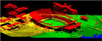
Lidar (Light detection and ranging) discrete-return point cloud data are available in the American Society for Photogrammetry and Remote Sensing (ASPRS) LAS format. The LAS format is a standardized binary format for storing 3-dimensional point cloud data and point attributes along with header information and variable length records specific to the data. Millions of data points are stored as a 3-dimensional data cloud as a series of x (longitude), y (latitude) and z (elevation) points. A few older projects in this collection are in ASCII format. Please refer to http://www.asprs.org/Committee-General/LASer-LAS-File-Format-Exchange-Activities.html for additional information.
Types: Citation;
Tags: Cartography,
DEM,
Digital Elevation Model,
Digital Mapping,
Digital Terrain Model,

Lidar (Light detection and ranging) discrete-return point cloud data are available in the American Society for Photogrammetry and Remote Sensing (ASPRS) LAS format. The LAS format is a standardized binary format for storing 3-dimensional point cloud data and point attributes along with header information and variable length records specific to the data. Millions of data points are stored as a 3-dimensional data cloud as a series of x (longitude), y (latitude) and z (elevation) points. A few older projects in this collection are in ASCII format. Please refer to http://www.asprs.org/Committee-General/LASer-LAS-File-Format-Exchange-Activities.html for additional information.

Lidar (Light detection and ranging) discrete-return point cloud data are available in the American Society for Photogrammetry and Remote Sensing (ASPRS) LAS format. The LAS format is a standardized binary format for storing 3-dimensional point cloud data and point attributes along with header information and variable length records specific to the data. Millions of data points are stored as a 3-dimensional data cloud as a series of x (longitude), y (latitude) and z (elevation) points. A few older projects in this collection are in ASCII format. Please refer to http://www.asprs.org/Committee-General/LASer-LAS-File-Format-Exchange-Activities.html for additional information.
This dataset is a LAS (industry-standard binary format for storing large point clouds) dataset containing light detection and ranging (LiDAR) data and sonar data representing the beach and near-shore topography of Lake Superior at Minnesota Point, Duluth, Minnesota. Average point spacing of the LAS files in the dataset are as follows: LiDAR, 0.137 meters (m); multi-beam sonar, 1.029 m; single-beam sonar, 0.999 m. The LAS dataset was used to create a 10-m (32.8084 feet) digital elevation model (DEM) of the approximately 5.9 square kilometer (2.3 square mile) surveyed area using the "LAS dataset to raster" tool in Esri ArcGIS, version 10.7. LiDAR data were collected August 10, 2019 using a boat-mounted Optech ILRIS...
Types: Map Service,
OGC WFS Layer,
OGC WMS Layer,
OGC WMS Service;
Tags: Bathymetry and Elevation,
DEM,
Duluth,
Great Lakes,
Hydroacoustic,
These data are digital elevation models (DEMs) of the beach topography and near-shore bathymetry of Lake Superior at Minnesota Point, near the Superior entry, Duluth, Minnesota. The DEMs have 1 meter (m; 3.28084 ft) and/or 10 m (32.8084 ft) cell size and was created from a LAS dataset of terrestrial light detection and ranging (LiDAR) data representing the beach topography and sonar data representing the bathymetry for an approximate 1.78 square kilometer survey area. Average point spacing of the LAS files in the dataset are as follows: lidar, 0.055 meters (m); multibeam sonar, 0.511 m; single-beam sonar, 1.687 m. Lidar data were collected November 01, 2022 using a boat mounted Velodyne VLP-16 unit and methodology...
Categories: Data;
Types: Downloadable,
GeoTIFF,
Map Service,
Raster;
Tags: Bathymetry and Elevation,
DEM,
Duluth,
Great Lakes,
Hydroacoustic,
This dataset is a LAS (industry-standard binary format for storing lidar point clouds) dataset containing light detection and ranging (lidar) data and sonar data representing the beach and near-shore bathymetry of Lake Superior at Minnesota Point, near the Duluth entry, Duluth, Minnesota. Average point spacing of the LAS files in the dataset are as follows: lidar, 0.055 meters (m); multibeam sonar, 0.511 m; single-beam sonar, 1.687 m. The LAS dataset was used to create digital elevation models (DEMs) of 10 m (32.8084 feet) and 1 m (3.28084 feet) cell size, of the approximate 1.78 square kilometer surveyed area. Lidar data were collected November 01, 2022 using a boat mounted Velodyne VLP-16 unit and methodology...
Categories: Data;
Types: Downloadable,
Map Service,
OGC WFS Layer,
OGC WMS Layer,
Shapefile;
Tags: Bathymetry and Elevation,
DEM,
Duluth,
Great Lakes,
Hydroacoustic,
Log ASCII Standard (LAS) files of select scanned well logs from Idaho Geological Surveys publication DD-3: Historical Oil and Gas Data for Idaho database of exploration wells across the state. Logs curves converted to LAS files may include: Gamma, Caliper (cal), Resistivity, Spontaneous Potential (SP), Bulk Density, Neutron Porosity, and density porosity. Locations of boreholes, attributes, and PDFs of more than 700 Geophysical logs and other data can be downloaded or viewed at no cost via the Idaho Geological Surveys interactive Oil and Gas webmap.
Log ASCII Standard (LAS) files of select scanned well logs from Idaho Geological Surveys publication DD-3: Historical Oil and Gas Data for Idaho database of exploration wells across the state. Logs curves converted to LAS files may include: Gamma, Caliper (cal), Resistivity, Spontaneous Potential (SP), Bulk Density, Neutron Porosity, and density porosity. Locations of boreholes, attributes, and PDFs of more than 700 Geophysical logs and other data can be downloaded or viewed at no cost via the Idaho Geological Surveys interactive Oil and Gas webmap.
U.S. Geological Survey, Department of the Interior - The annual lidar and DEM acquisition plan is part of the 3DEP initiative to systematically collect enhanced elevation data (Quality Level 2) in the form of high-quality light detection and ranging (lidar) data over the conterminous United States, Hawaii, and the territories on an 8-year schedule. The FY17 acquisition plan currently anticipates collecting 225,000 sq. mi. or more depending on partnerships and other contributions to the plan. Interested parties who wish to become a funding partner with the USGS in FY17 or in future years should contact a USGS Geospatial Liaison - http://liaisons.usgs.gov/geospatial/documents/TNM_Partnership_User_ContactList.pdf....

Lidar (Light detection and ranging) discrete-return point cloud data are available in the American Society for Photogrammetry and Remote Sensing (ASPRS) LAS format. The LAS format is a standardized binary format for storing 3-dimensional point cloud data and point attributes along with header information and variable length records specific to the data. Millions of data points are stored as a 3-dimensional data cloud as a series of x (longitude), y (latitude) and z (elevation) points. A few older projects in this collection are in ASCII format. Please refer to http://www.asprs.org/Committee-General/LASer-LAS-File-Format-Exchange-Activities.html for additional information.

Lidar (Light detection and ranging) discrete-return point cloud data are available in the American Society for Photogrammetry and Remote Sensing (ASPRS) LAS format. The LAS format is a standardized binary format for storing 3-dimensional point cloud data and point attributes along with header information and variable length records specific to the data. Millions of data points are stored as a 3-dimensional data cloud as a series of x (longitude), y (latitude) and z (elevation) points. A few older projects in this collection are in ASCII format. Please refer to http://www.asprs.org/Committee-General/LASer-LAS-File-Format-Exchange-Activities.html for additional information.

Lidar (Light detection and ranging) discrete-return point cloud data are available in the American Society for Photogrammetry and Remote Sensing (ASPRS) LAS format. The LAS format is a standardized binary format for storing 3-dimensional point cloud data and point attributes along with header information and variable length records specific to the data. Millions of data points are stored as a 3-dimensional data cloud as a series of x (longitude), y (latitude) and z (elevation) points. A few older projects in this collection are in ASCII format. Please refer to http://www.asprs.org/Committee-General/LASer-LAS-File-Format-Exchange-Activities.html for additional information.
Types: Citation;
Tags: Cartography,
DEM,
Digital Elevation Model,
Digital Mapping,
Digital Terrain Model,

Lidar (Light detection and ranging) discrete-return point cloud data are available in the American Society for Photogrammetry and Remote Sensing (ASPRS) LAS format. The LAS format is a standardized binary format for storing 3-dimensional point cloud data and point attributes along with header information and variable length records specific to the data. Millions of data points are stored as a 3-dimensional data cloud as a series of x (longitude), y (latitude) and z (elevation) points. A few older projects in this collection are in ASCII format. Please refer to http://www.asprs.org/Committee-General/LASer-LAS-File-Format-Exchange-Activities.html for additional information.
Types: Citation;
Tags: Cartography,
DEM,
Digital Elevation Model,
Digital Mapping,
Digital Terrain Model,
Low-altitude (80-100 meters above ground level) digital images were obtained from a camera mounted on a 3DR Solo quadcopter, a small unmanned aerial system (UAS), in three locations along the Lake Ontario shoreline in New York during July 2017. These data were collected to document and monitor effects of high lake levels, including shoreline erosion, inundation, and property damage in the vicinity of Chimney Bluffs State Park, New York. This data release includes images tagged with locations determined from the UAS GPS; tables with updated estimates of camera positions and attitudes based on the photogrammetric reconstruction; tables listing locations of the base stations, ground control points, and transect points;...

Lidar (Light detection and ranging) discrete-return point cloud data are available in the American Society for Photogrammetry and Remote Sensing (ASPRS) LAS format. The LAS format is a standardized binary format for storing 3-dimensional point cloud data and point attributes along with header information and variable length records specific to the data. Millions of data points are stored as a 3-dimensional data cloud as a series of x (longitude), y (latitude) and z (elevation) points. A few older projects in this collection are in ASCII format. Please refer to http://www.asprs.org/Committee-General/LASer-LAS-File-Format-Exchange-Activities.html for additional information.
|

|
