Filters: Tags: Lassen County (X) > Date Range: {"choice":"year"} (X)
10 results (96ms)|
Filters
Date Types (for Date Range)
Contacts
Categories Tag Types Tag Schemes |

The High Resolution National Hydrography Dataset Plus (NHDPlus HR) is an integrated set of geospatial data layers, including the National Hydrography Dataset (NHD), National Watershed Boundary Dataset (WBD), and 3D Elevation Program Digital Elevation Model (3DEP DEM). The NHDPlus HR combines the NHD, 3DEP DEMs, and WBD to a data suite that includes the NHD stream network with linear referencing functionality, the WBD hydrologic units, elevation-derived catchment areas for each stream segment, "value added attributes" (VAAs), and other features that enhance hydrologic data analysis and routing.
This dataset includes georeferenced high-resolution, airborne thermal infrared (TIR) imagery, a polyline shapefile of the channel centerline, and a tabular file with longitudinal stream temperature profiles for Hat Creek, California. The two aerial TIR surveys were conducted with a helicopter by NV5 Geospatial (formerly Quantum Spatial, Inc.) and are published as two raster mosaics in GeoTiff format with a resolution of 0.5 m. The TIR mosaics and longitudinal stream temperature profiles contain corrected surface temperatures in degrees C (multiplied by 10 to create an unsigned integer pixel type). The TIR dataset encompasses a 64.6-km reach of Hat Creek that extends from 50 m upstream of the confluence with Lost...
Types: Map Service,
OGC WFS Layer,
OGC WMS Layer,
OGC WMS Service;
Tags: California,
Hat Creek,
Hydrology,
Lassen County,
Remote Sensing,
The California Groundwater Ambient Monitoring and Assessment Program Priority Basin Project (GAMA-PBP) analyzed for per-and polyfluoroalkyl substances (PFAS) in groundwater samples collected from domestic and public drinking water supply wells in California. GAMA-PBP is a cooperative program between the U.S. Geological Survey and the California State Water Resources Control Board. This data release contains data for samples collected from May 2019 through December 2022 and includes revisions to earlier data (Kent, 2021) that were either screened or removed after analysis of quality-control data. Please see the quality-control and other descriptions of the data in the processing steps in the xml file. Subsequent...
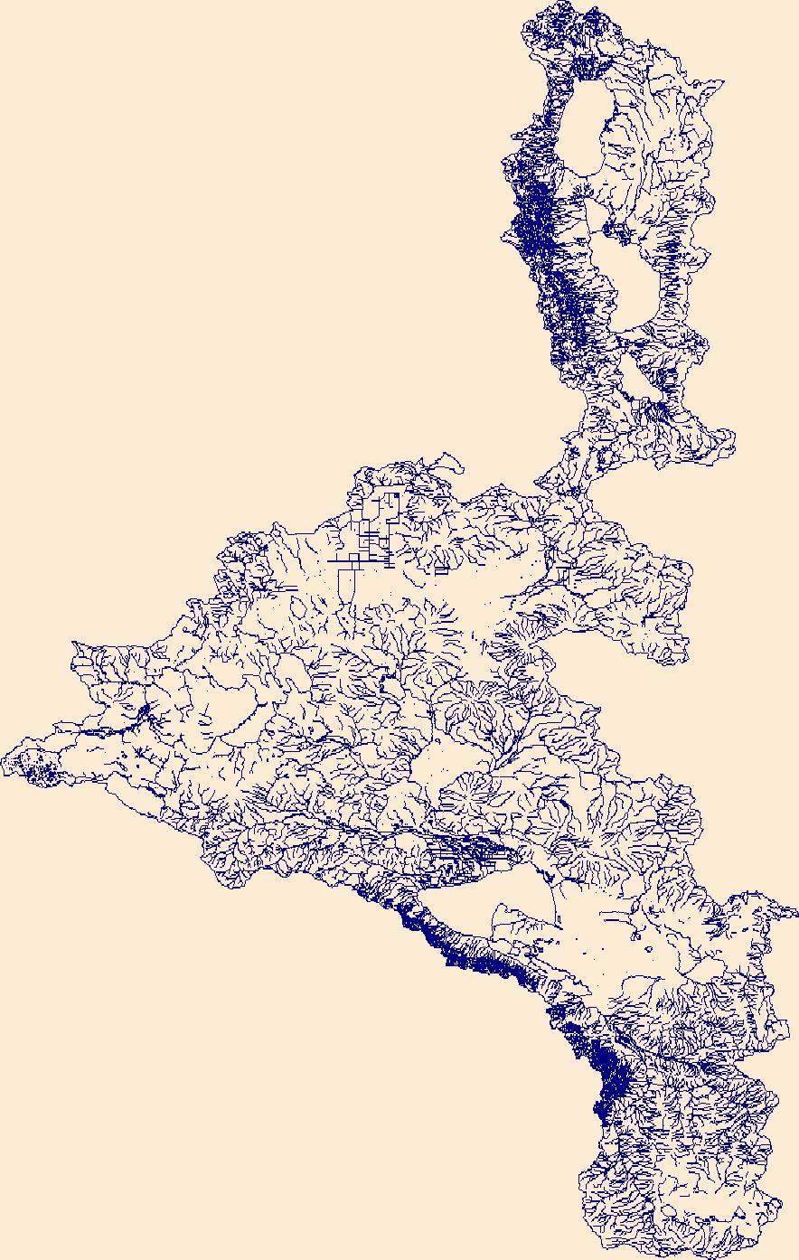
The High Resolution National Hydrography Dataset Plus (NHDPlus HR) is an integrated set of geospatial data layers, including the best available National Hydrography Dataset (NHD), the 10-meter 3D Elevation Program Digital Elevation Model (3DEP DEM), and the National Watershed Boundary Dataset (WBD). The NHDPlus HR combines the NHD, 3DEP DEMs, and WBD to create a stream network with linear referencing, feature naming, "value added attributes" (VAAs), elevation-derived catchments, and other features for hydrologic data analysis. The stream network with linear referencing is a system of data relationships applied to hydrographic systems so that one stream reach "flows" into another and "events" can be tied to and traced...
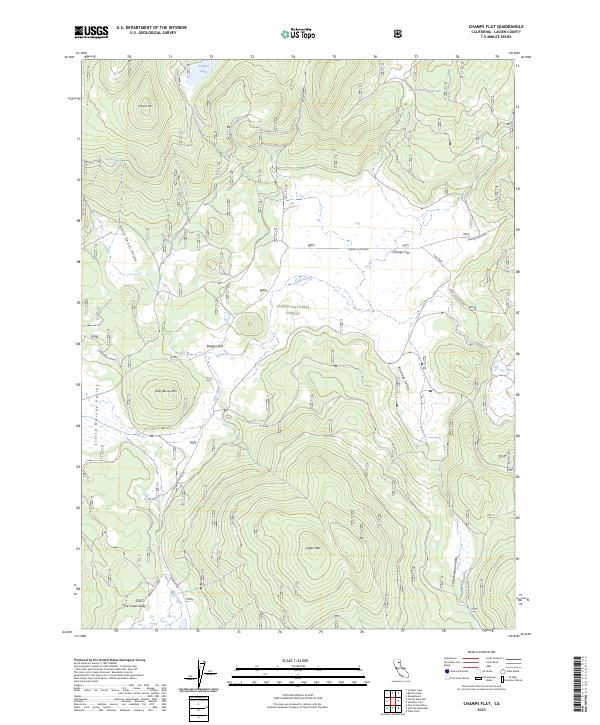
Layered geospatial PDF 7.5 Minute Quadrangle Map. Layers of geospatial data include orthoimagery, roads, grids, geographic names, elevation contours, hydrography, and other selected map features. This map is derived from GIS (geospatial information system) data. It represents a repackaging of GIS data in traditional map form, not creation of new information. The geospatial data in this map are from selected National Map data holdings and other government sources.
This data release has been deprecated. Please see new data release here: https://doi.org/10.5066/P9ETQ00R The U.S. Geological Survey Groundwater Ambient Monitoring and Assessment-Priority Basin Project (USGS GAMA-PBP) collected samples to be analyzed for per-and polyfluoroalkyl substances (PFAS) from domestic and public supply wells from May 2019 to June 2021. The datasets presented here include identification of the 28 PFAS constituents monitored by the project, Identification and brief characterization of the 395 GAMA-PBP wells for which samples were analyzed for PFAS during the study period, and analytical results for those groundwater samples, along with results for quality control samples.
An updated version has been published: Halstead, B.J., Kleeman, P.M., and Rose, J.P., 2024, Northwestern pond turtle survey data in northern California forest streams, 2021-2022: U.S. Geological Survey data release, https://doi.org/10.5066/P96GAPCC. These data are from joint visual encounter and environmental DNA (eDNA) surveys conducted for northwestern pond turtles (Actinemys marmorata) in streams on privately-owned timberlands in northern California.
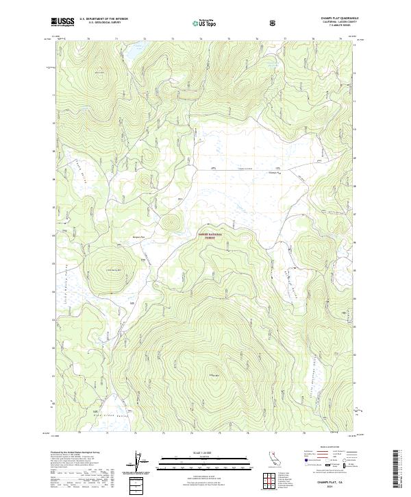
Layered geospatial PDF 7.5 Minute Quadrangle Map. Layers of geospatial data include orthoimagery, roads, grids, geographic names, elevation contours, hydrography, and other selected map features. This map is derived from GIS (geospatial information system) data. It represents a repackaging of GIS data in traditional map form, not creation of new information. The geospatial data in this map are from selected National Map data holdings and other government sources.

The High Resolution National Hydrography Dataset Plus (NHDPlus HR) is an integrated set of geospatial data layers, including the best available National Hydrography Dataset (NHD), the 10-meter 3D Elevation Program Digital Elevation Model (3DEP DEM), and the National Watershed Boundary Dataset (WBD). The NHDPlus HR combines the NHD, 3DEP DEMs, and WBD to create a stream network with linear referencing, feature naming, "value added attributes" (VAAs), elevation-derived catchments, and other features for hydrologic data analysis. The stream network with linear referencing is a system of data relationships applied to hydrographic systems so that one stream reach "flows" into another and "events" can be tied to and traced...
These data are from joint visual encounter and environmental DNA (eDNA) surveys conducted for northwestern pond turtles (Actinemys marmorata) in streams on privately-owned timberlands in northern California.
|

|
