Filters: Tags: Louisiana (X) > Date Range: {"choice":"year"} (X)
1,245 results (64ms)|
Filters
Date Types (for Date Range)
Types Contacts
Categories Tag Types
|
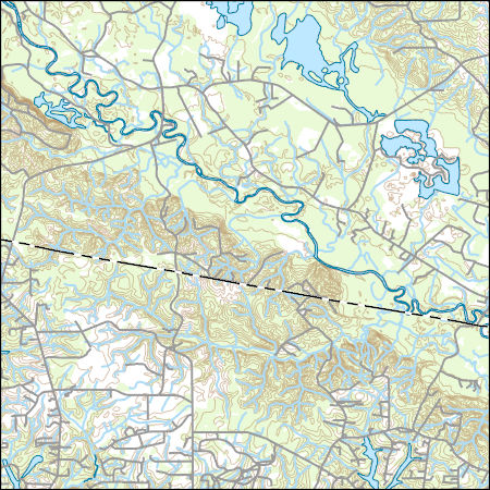
Layers of geospatial data include contours, boundaries, land cover, hydrography, roads, transportation, geographic names, structures, and other selected map features.

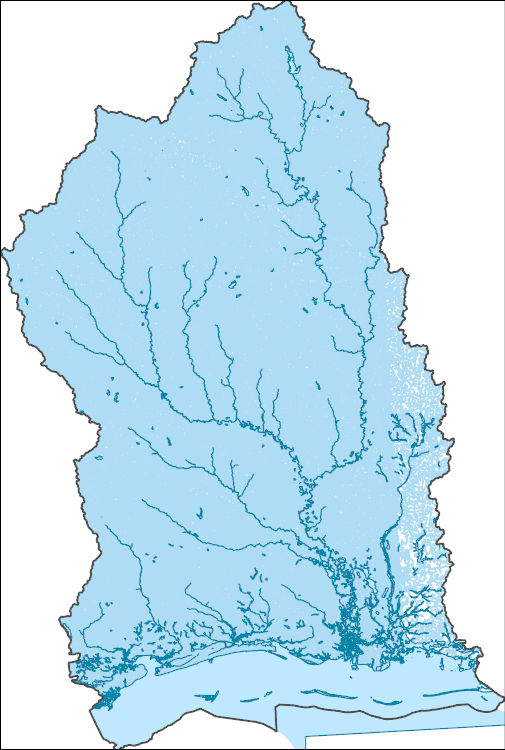
The Watershed Boundary Dataset (WBD) is a comprehensive aggregated collection of hydrologic unit data consistent with the national criteria for delineation and resolution. It defines the areal extent of surface water drainage to a point except in coastal or lake front areas where there could be multiple outlets as stated by the "Federal Standards and Procedures for the National Watershed Boundary Dataset (WBD)" "Standard" (https://pubs.usgs.gov/tm/11/a3/). Watershed boundaries are determined solely upon science-based hydrologic principles, not favoring any administrative boundaries or special projects, nor particular program or agency. This dataset represents the hydrologic unit boundaries to the 12-digit (6th level)...
Forest Retention Index classes for the southeastern United States at 2040 were processed using the Forest Retention Decision Tree and rendered on a 30-meter by 30-meter grid. The Forest Retention Index is used only for current forestland, identified using National Land Cover Database 2011. Many datasets were used as inputs for the Forest Retention Decision Tree, and they can be grouped into five broad categories: Protected, Tier 1 Priority, Tier 2 Priority, Threats to Forest Retention, and Socio-Economic Value of Forests. Protected datasets include Protected Areas Database-United States, National Conservation Easement Database, state-maintained databases, and private datasets volunteered by conservation partners....
Categories: Data;
Types: ArcGIS REST Map Service,
ArcGIS Service Definition,
Downloadable,
Map Service;
Tags: Alabama,
Arkansas,
Florida,
Georgia,
Illinois,
The balance between economic needs and natural resource conservation will become more tenuous in the future as a result of a myriad of environmental stressors. We propose a methodology that can help guide forest management practices whenever adequate species locational data and quality forest or land use data exist. More specifically, the results of this study can be used to evaluate alternative land and silviculture management scenarios in terms of creating or maintaining high-quality forest habitat for a specific species. We used data collected on radiotelemetered black bears from 1988 to 2015 to develop a regional habitat model throughout Louisiana and Arkansas using Mahalanobis distance (D2) statistic. We created...
Categories: Data;
Tags: Arkansas,
Consevation design,
LCC Network Science Catalog,
Louisiana,
Mahalanobis distance,

The Geographic Names Information System (GNIS) is the Federal standard for geographic nomenclature. The U.S. Geological Survey developed the GNIS for the U.S. Board on Geographic Names, a Federal inter-agency body chartered by public law to maintain uniform feature name usage throughout the Government and to promulgate standard names to the public. The GNIS is the official repository of domestic geographic names data; the official vehicle for geographic names use by all departments of the Federal Government; and the source for applying geographic names to Federal electronic and printed products of all types.
The National Hydrography Dataset (NHD) is a feature-based database that interconnects and uniquely identifies the stream segments or reaches that make up the nation's surface water drainage system. NHD data was originally developed at 1:100,000-scale and exists at that scale for the whole country. This high-resolution NHD, generally developed at 1:24,000/1:12,000 scale, adds detail to the original 1:100,000-scale NHD. (Data for Alaska, Puerto Rico and the Virgin Islands was developed at high-resolution, not 1:100,000 scale.) Local resolution NHD is being developed where partners and data exist. The NHD contains reach codes for networked features, flow direction, names, and centerline representations for areal water...
Wetland restoration efforts conducted by the Coastal Wetlands Planning, Protection and Restoration Act (CWPPRA) in Louisiana rely on monitoring to determine the efficacy of these projects. The Coastwide Reference Monitoring System (CRMS) was developed to assist in a multiple-reference approach that uses aspects of hydrogeomorphic functional assessments and probabilistic sampling for monitoring. The CRMS program includes a suite of approximately 390 sites that encompass the range of hydrological and ecological conditions for each stratum. As part of CRMS, land and water classifications are created from Digital Orthophoto Quarter Quadrangles (DOQQs) approximately every three years at all CRMS sites. This dataset consists...
Categories: Data;
Types: Downloadable,
GeoTIFF,
Map Service,
Raster;
Tags: CRMS,
DOQQ,
Emergent Wetland,
Forested Wetland,
Geographic Information System,
This data release includes 2022 data for the Louisiana Outer Coast Restoration Project for Whiskey Island. Specifically, this data release includes a detailed habitat map, general habitat map, and georeferenced imagery. These habitat maps are developed using the methods and classification scheme from Louisiana Coastal Protection and Restoration Authority’s (CPRA) Barrier Island Comprehensive Monitoring (BICM) program. For more details on BICM habitat classes, see the Entity and Attribute Information section of the metadata. Please consult the accompanying readME.txt file for information and recommendations on the contents of this dataset (that is, dataset and recommended symbology). For more information about BICM...
Wetland restoration efforts conducted by the Coastal Wetlands Planning, Protection and Restoration Act (CWPPRA) in Louisiana rely on monitoring efforts to determine the efficacy of these efforts. The Coastwide Reference Monitoring System (CRMS) was developed to assist in a multiple-reference approach that uses aspects of hydrogeomorphic functional assessments and probabilistic sampling for monitoring. The CRMS program includes a suite of approximately 398 sites that encompass the range of hydrological and ecological conditions for each stratum. As part of CRMS, land and water classifications are created from Digital Orthophoto Quarter Quadrangles (DOQQs) approximately every three years at all CRMS sites. A DOQQ...
Categories: Data;
Types: Downloadable,
GeoTIFF,
Map Service,
Raster;
Tags: CRMS,
DOQQ,
Emergent Wetland,
Forested Wetland,
Geographic Information System,
|

|
