Filters: Tags: Massachusetts (X) > Date Range: {"choice":"year"} (X)
381 results (87ms)|
Filters
Date Types (for Date Range)
Types
Contacts
Categories
Tag Types
|
This data release includes water-quality data collected at up to thirteen locations along the Merrimack River and Merrimack River Estuary in Massachusetts. In this study, conducted by the U.S. Geological Survey (USGS) in cooperation with the Massachusetts Department of Environmental Protection, discrete samples were collected, and continuous monitoring was completed from June to September 2020. The data include results of measured field properties (water temperature, specific conductivity, pH, dissolved oxygen) and laboratory concentrations of nitrogen and phosphorus species, total carbon, pheophytin-a, and chlorophyll-a. These data were collected to assess selected (mainly nutrients) water-quality conditions in...
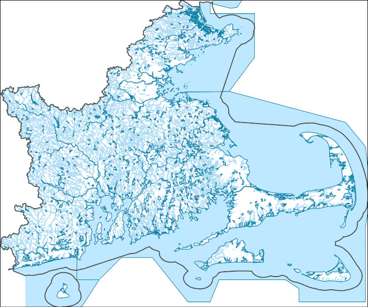
The National Hydrography Dataset (NHD) is a feature-based database that interconnects and uniquely identifies the stream segments or reaches that make up the nation's surface water drainage system. NHD data was originally developed at 1:100,000-scale and exists at that scale for the whole country. This high-resolution NHD, generally developed at 1:24,000/1:12,000 scale, adds detail to the original 1:100,000-scale NHD. (Data for Alaska, Puerto Rico and the Virgin Islands was developed at high-resolution, not 1:100,000 scale.) Local resolution NHD is being developed where partners and data exist. The NHD contains reach codes for networked features, flow direction, names, and centerline representations for areal water...
Geospatial data includes structures and other selected map features.
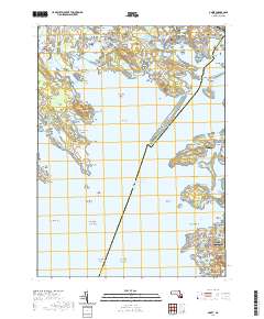
Layered geospatial PDF 7.5 Minute Quadrangle Map. Layers of geospatial data include orthoimagery, roads, grids, geographic names, elevation contours, hydrography, and other selected map features. This map is derived from GIS (geospatial information system) data. It represents a repackaging of GIS data in traditional map form, not creation of new information. The geospatial data in this map are from selected National Map data holdings and other government sources.
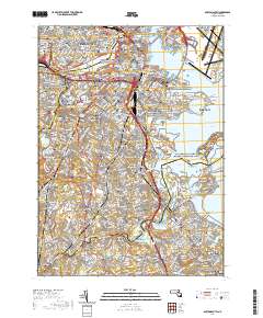
Layered geospatial PDF 7.5 Minute Quadrangle Map. Layers of geospatial data include orthoimagery, roads, grids, geographic names, elevation contours, hydrography, and other selected map features. This map is derived from GIS (geospatial information system) data. It represents a repackaging of GIS data in traditional map form, not creation of new information. The geospatial data in this map are from selected National Map data holdings and other government sources.
The dwarf wedgemussel (Alasmidonta heterodon) is a federally endangered freshwater mussel that once ranged from New Brunswick to North Carolina, but now only exists in isolated populations throughout its diminished range. This study aimed to understand links between fish abundance and dwarf wedgemussel abundance and occurrence in the Connecticut and Delaware watersheds. Specifically, my study objectives were to 1) characterize fish assemblages near dwarf wedgemussel locations and unoccupied locations, 2) determine if dwarf wedgemussel occurrence and abundance are related to abundance of the known host fish species, tessellated darter and other potential host fish species per St. John White et. al. (2017). Two fish...
The data in this release re-map the beach and nearshore environment at Head of the Meadow Beach in Truro, MA and provide updated environmental context for the 2020 CoastCam installation that looks out at the coast shared by beachgoers, shorebirds, seals, and sharks. This is related to the field activity 2022-015-FA and a collaboration with the National Park Service at Cape Cod National Seashore to monitor the region that falls within the field of view of CoastCam CACO-01, which are two video cameras aimed at the beach. In March and April 2023, U.S. Geological Survey and Woods Hole Oceanographic Institute (WHOI) scientists conducted field surveys to collect topographic and bathymetric data. Images of the beach for...
Categories: Data;
Tags: AeroPoint,
CMHRP,
Cape Cod,
Coastal and Marine Hazards and Resources Program,
GPS measurement,
The data in this release re-map the beach and nearshore environment at Marconi Beach in Wellfleet, MA and provide updated environmental context for the 2021 CoastCam installation that looks out at the coast shared by beachgoers, shorebirds, seals, and sharks. This is related to the field activity 2022-014-FA and a collaboration with the National Park Service at Cape Cod National Seashore to monitor the region that falls within the field of view of CoastCam CACO-02, which are two video cameras aimed at the beach. In March 2023, U.S. Geological Survey and Woods Hole Oceanographic Institute (WHOI) scientists conducted field surveys to collect topographic and bathymetric data. Images of the beach for use in structure-from-motion...
Categories: Data;
Tags: ASV,
CMHRP,
Cape Cod,
Coastal and Marine Hazards and Resources Program,
Marconi Beach,
The data in this release re-map the beach and nearshore environment at Marconi Beach in Wellfleet, MA and provide updated environmental context for the 2021 CoastCam installation that looks out at the coast shared by beachgoers, shorebirds, seals, and sharks. This is related to the field activity 2022-014-FA and a collaboration with the National Park Service at Cape Cod National Seashore to monitor the region that falls within the field of view of CoastCam CACO-02, which are two video cameras aimed at the beach. In March 2023, U.S. Geological Survey and Woods Hole Oceanographic Institute (WHOI) scientists conducted field surveys to collect topographic and bathymetric data. Images of the beach for use in structure-from-motion...
Categories: Data;
Tags: AeroPoint,
CMHRP,
Cape Cod,
Coastal and Marine Hazards and Resources Program,
GPS measurement,

The Geographic Names Information System (GNIS) is the Federal standard for geographic nomenclature. The U.S. Geological Survey developed the GNIS for the U.S. Board on Geographic Names, a Federal inter-agency body chartered by public law to maintain uniform feature name usage throughout the Government and to promulgate standard names to the public. The GNIS is the official repository of domestic geographic names data; the official vehicle for geographic names use by all departments of the Federal Government; and the source for applying geographic names to Federal electronic and printed products of all types.
Management efforts of the tidally-restricted Herring River in Wellfleet, MA include research to understand pre-restoration sediment conditions. Submerged multiparameter sondes that measure optical turbidity were deployed at four sites landward and seaward of the Herring River restriction. Periodically, the sites were visited and additional turbidity measurements were collected with a handheld multiparameter sonde, and water samples were collected for determination of suspended-sediment concentration (SSC). The handheld turbidity measurements were regressed against SSC using a repeated median regression to determine a calibration curve for calibrating the turbidity time-series data to SSC. The SSC derived from the...
Categories: Data;
Tags: Cape Cod National Seashore,
Herring River,
Massachusetts,
Water Quality,
Wellfleet,
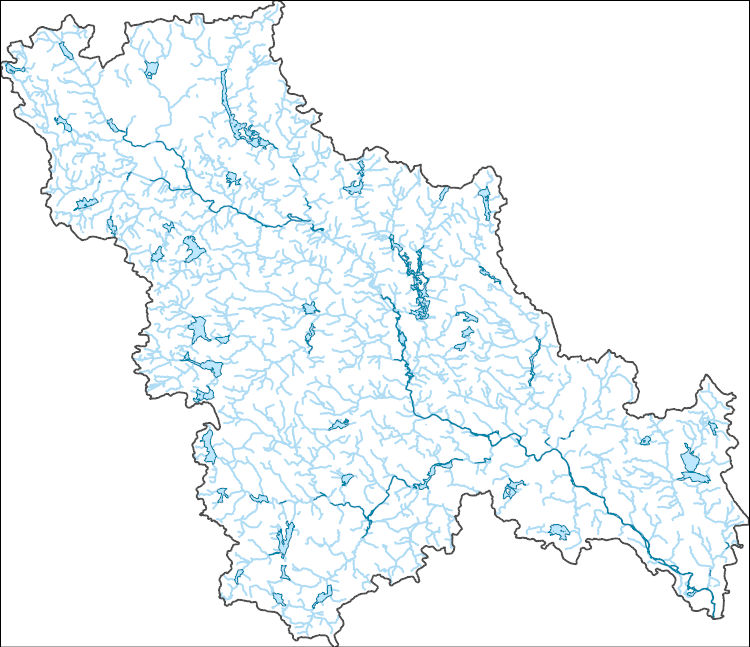
The National Hydrography Dataset (NHD) is a feature-based database that interconnects and uniquely identifies the stream segments or reaches that make up the nation's surface water drainage system. NHD data was originally developed at 1:100,000-scale and exists at that scale for the whole country. This high-resolution NHD, generally developed at 1:24,000/1:12,000 scale, adds detail to the original 1:100,000-scale NHD. (Data for Alaska, Puerto Rico and the Virgin Islands was developed at high-resolution, not 1:100,000 scale.) Local resolution NHD is being developed where partners and data exist. The NHD contains reach codes for networked features, flow direction, names, and centerline representations for areal water...
This child item describes Python code used to estimate average yearly and monthly tourism per 1000 residents within public-supply water service areas. Increases in population due to tourism may impact amounts of water used by public-supply water systems. This data release contains model input datasets, Python code used to develop the tourism information, and output estimates of tourism. This dataset is part of a larger data release using machine learning to predict public supply water use for 12-digit hydrologic units from 2000-2020. Output from this code was used as an input feature in the public supply delivery and water use machine learning models. This page includes the following files: tourism_input_data.zip...
This child item describes a public supply delivery machine learning model that was developed to estimate public-supply deliveries. Publicly supplied water may be delivered to domestic users or to commercial, industrial, institutional, and irrigation (CII) users. This model predicts total, domestic, and CII per capita rates for public-supply water service areas within the conterminous United States for 2009-2020. This child item contains model input datasets, code used to build the delivery machine learning model, and national predictions. This dataset is part of a larger data release using machine learning to predict public-supply water use for 12-digit hydrologic units from 2000-2020. This page includes the following...
This child item describes Python code used to query census data from the TigerWeb Representational State Transfer (REST) services and the U.S. Census Bureau Application Programming Interface (API). These data were needed as input feature variables for a machine learning model to predict public supply water use for the conterminous United States. Census data were retrieved for public-supply water service areas, but the census data collector could be used to retrieve data for other areas of interest. This dataset is part of a larger data release using machine learning to predict public supply water use for 12-digit hydrologic units from 2000-2020. Data retrieved by the census data collector code were used as input...

The High Resolution National Hydrography Dataset Plus (NHDPlus HR) is an integrated set of geospatial data layers, including the National Hydrography Dataset (NHD), National Watershed Boundary Dataset (WBD), and 3D Elevation Program Digital Elevation Model (3DEP DEM). The NHDPlus HR combines the NHD, 3DEP DEMs, and WBD to a data suite that includes the NHD stream network with linear referencing functionality, the WBD hydrologic units, elevation-derived catchment areas for each stream segment, "value added attributes" (VAAs), and other features that enhance hydrologic data analysis and routing.
This map layer shows major ports in the United States, Puerto Rico, and the U.S. Virgin Islands. A port is a city, town, or urban area with a harbor where ships load or unload. This is a revised version of the July 2012 map layer.
Categories: Data;
Types: Downloadable,
Map Service,
OGC WFS Layer,
OGC WMS Layer,
Shapefile;
Tags: Academics & scientific researchers,
Alabama,
Arizona,
Arkansas,
California,
This data set represents the extent, approximate location and type of wetlands and deepwater habitats in the United States and its Territories. These data delineate the areal extent of wetlands and surface waters as defined by Cowardin et al. (1979). Certain wetland habitats are excluded from the National mapping program because of the limitations of aerial imagery as the primary data source used to detect wetlands. These habitats include seagrasses or submerged aquatic vegetation that are found in the intertidal and subtidal zones of estuaries and near shore coastal waters. Some deepwater reef communities (coral or tuberficid worm reefs) have also been excluded from the inventory. These habitats, because of their...
Categories: Data;
Types: Map Service,
OGC WFS Layer,
OGC WMS Layer,
OGC WMS Service;
Tags: Academics & scientific researchers,
Alabama,
Alabama,
Alaska,
Arizona,

The High Resolution National Hydrography Dataset Plus (NHDPlus HR) is an integrated set of geospatial data layers, including the National Hydrography Dataset (NHD), National Watershed Boundary Dataset (WBD), and 3D Elevation Program Digital Elevation Model (3DEP DEM). The NHDPlus HR combines the NHD, 3DEP DEMs, and WBD to a data suite that includes the NHD stream network with linear referencing functionality, the WBD hydrologic units, elevation-derived catchment areas for each stream segment, "value added attributes" (VAAs), and other features that enhance hydrologic data analysis and routing.
|

|
