Filters: Tags: NHD (X) > Types: Citation (X)
12 results (101ms)|
Filters
Date Range
Extensions Types
Contacts
Categories Tag Types Tag Schemes |

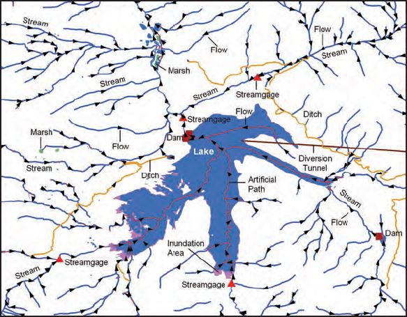
The USGS National Hydrography Dataset (NHD) service from The National Map (TNM) is a comprehensive set of digital spatial data that encodes information about naturally occurring and constructed bodies of surface water (lakes, ponds, and reservoirs), paths through which water flows (canals, ditches, streams, and rivers), and related entities such as point features (springs, wells, stream gages, and dams). The information encoded about these features includes classification and other characteristics, delineation, geographic name, position and related measures, a "reach code" through which other information can be related to the NHD, and the direction of water flow. The network of reach codes delineating water and...
The locations of approximately 26,000 current and historical U.S. Geological Survey (USGS) surface-water monitoring gaging stations have been indexed to the NHDPlus Version 2.1 stream network. Part of the USGS National Water Information System (NWIS), these gaging stations measure water flow and water levels in streams and lakes. The NHDPlus V2 stream network locations for these gaging stations differ from stations' latitude/longitude provided in NWIS. The NWIS coordinates are frequently not coincidenet with the NHDPlus stream network.
Categories: Data;
Types: Citation,
Downloadable,
Map Service,
OGC WFS Layer,
OGC WMS Layer,
Shapefile;
Tags: Gaging station,
HEM,
Hydro linked data,
Linear referencing,
Linked data,
Pour points derived from NHDPlus V2.1 flow direction rasters and the NHDPlus V2.1 WBD HU12 snapshot. Three sets of pour points are provided: From (fpp) and to (tpp) points that identify the location where raster flow leaves the HU12 polygon, and a third "vector pour point" (vpp) selected "upstream" for use in detecting flow confluences near the raster pour point locations. This dataset is PROVISIONAL and SUBJECT TO REVISION.
Categories: Data;
Types: Citation,
Downloadable,
Map Service,
OGC WFS Layer,
OGC WMS Layer,
Shapefile;
Tags: Hydrographically linked data,
NHD,
National Hydrography Dataset,
North America,
Point Event,
Landforms along the Pacific, Gulf of Mexico, and Atlantic coastlines for the conterminous United States are attributed with the relative vulnerability of horizontal erosion due to sea-level rise to characterize coastal zone stability. The position and extent of landforms are geospatially indexed as line-events where these coastal zone features are intersected by the linear-referenced 2013 - 2014 U.S. Geological Survey National Hydrography Dataset Coastline, which corresponds to the National Oceanic and Atmospheric Administration (NOAA) 2013 - 2014 mean high water level datum delineated in intertidal zones open to oceans, behind barrier coasts in bays, lagoons, and estuaries, and sometimes where tidal currents reach...
Categories: Data,
Data Release - In Progress,
Publication;
Types: ArcGIS REST Map Service,
ArcGIS Service Definition,
Citation,
Downloadable,
Map Service,
OGC WFS Layer,
OGC WMS Layer,
Shapefile;
Tags: Geomorphology,
Gulf,
Gulf of Mexico,
HEM,
Hydro linked data,
Landforms along the Pacific, Gulf of Mexico, and Atlantic coastlines for the conterminous United States are attributed with the relative vulnerability of horizontal erosion due to sea-level rise to characterize coastal zone stability. The position and extent of landforms are geospatially indexed as line-events where these coastal zone features are intersected by the linear-referenced 2013 - 2014 U.S. Geological Survey National Hydrography Dataset Coastline, which corresponds to the National Oceanic and Atmospheric Administration (NOAA) 2013 - 2014 mean high water level datum delineated in intertidal zones open to oceans, behind barrier coasts in bays, lagoons, and estuaries, and sometimes where tidal currents reach...
Categories: Data,
Data Release - In Progress,
Publication;
Types: ArcGIS REST Map Service,
ArcGIS Service Definition,
Citation,
Downloadable,
Map Service,
OGC WFS Layer,
OGC WMS Layer,
Shapefile;
Tags: Atlantic,
Connecticut,
Delaware,
Florida,
Geomorphology,
HEM events were created from fish screens, stream gages, and surface water diversions within the Lemhi SubBasin in Idaho. Data was gathered from the following sources: Idaho Fish and Game, Idaho Power, Idaho Water Engineering, and Idaho Water Resources Water Rights. The data assembled represented fish screens, water withdrawals from the stream, and flow gauging stations.
Categories: Data;
Types: ArcGIS REST Map Service,
ArcGIS Service Definition,
Citation,
Downloadable,
Map Service,
OGC WFS Layer,
OGC WMS Layer,
Shapefile;
Tags: HEM,
HEM,
NHD,
Point Event,
environment,
The National Hydrography Dataset (NHD) is a comprehensive set of digital spatial data that encodes information about naturally occurring and constructed bodies of surface water (lakes, ponds, and reservoirs), paths through which water flows (canals, ditches, streams, and rivers), and related entities such as point features (springs, wells, stream gages, and dams). The information encoded about these features includes classification and other characteristics, delineation, geographic name, position and related measures, a "reach code" through which other information can be related to the NHD, and the direction of water flow. The network of reach codes delineating water and transported material flow allows users to...
Landforms along the Pacific, Gulf of Mexico, and Atlantic coastlines for the conterminous United States are attributed with the relative vulnerability of horizontal erosion due to sea-level rise to characterize coastal zone stability. The position and extent of landforms are geospatially indexed as line-events where these coastal zone features are intersected by the linear-referenced 2013 - 2014 U.S. Geological Survey National Hydrography Dataset Coastline, which corresponds to the National Oceanic and Atmospheric Administration (NOAA) 2013 - 2014 mean high water level datum delineated in intertidal zones open to oceans, behind barrier coasts in bays, lagoons, and estuaries, and sometimes where tidal currents reach...
This polyline feature class depicts the classification of each wild and scenic river segment designated by Congress and the Secretary of the Interior for the United States and Puerto Rico. This layer was created by a multi-agency effort including the US Forest Service, National Park Service, Bureau of Land Management and the Fish and Wildlife Service. The spatial data were referenced to the latest High Resolution National Hydrological Data Layer (NHD 1:24,000 Scale or better), published by United States Geological Survey (USGS).“Wild” rivers are free of dams, generally inaccessible except by trail, and represent vestiges of primitive America. “Scenic” rivers are free of dams, with shorelines or watersheds still...
Categories: Data;
Types: ArcGIS REST Map Service,
ArcGIS Service Definition,
Citation,
Downloadable,
Map Service,
OGC WFS Layer,
OGC WMS Layer,
Shapefile;
Tags: Hydrographically linked data,
Line Event,
NHD,
Recreation,
River,
Point Events are data that USGS has linked to the NHD. These include USGS stream gages, dams, hydrologic unit outlets, stream flow alterations, and water quality stations.
Categories: Data;
Types: ArcGIS REST Map Service,
ArcGIS Service Definition,
Citation,
Downloadable,
Map Service,
OGC WFS Layer,
OGC WMS Layer,
Shapefile;
Tags: Dams,
Dams,
Divergences,
Divergences,
Gaging station,

USGS Hydro-NHD is a tile cache base map that combines hydrography data in The National Map from the National Hydrography Dataset (NHD) along with the Watershed Boundary Dataset (WBD). The NHD is a comprehensive set of digital spatial data that encodes information about naturally occurring and constructed bodies of surface water (lakes, ponds, and reservoirs), paths through which water flows (canals, ditches, streams, and rivers), and related entities such as point features (springs, wells, stream gages, and dams). The information encoded about these features includes classification and other characteristics, delineation, geographic name, position and related measures, a "reach code" through which other information...
U.S. Geological Survey, Department of the Interior - The annual National Hydrography Dataset (NHD) stewardship plan is to maintain hydrography data in the NHD over the United States and its territories. NHD for the nation has been collected and is now in maintenance mode. Interested parties who wish to become a NHD stewardship partner with the USGS in FY17 or in future years should contact a USGS Geospatial Liaison - http://liaisons.usgs.gov/geospatial/documents/TNM_Partnership_User_ContactList.pdf. To find out more about hydrography stewardship go to http://nhd.usgs.gov/stewardship.html or for exact project status information on areas currently in work go to http://nhd.usgs.gov/project_status.html
Types: Citation;
Tags: Hydrography,
NGDA,
NHD,
National Geospatial Data Asset,
National Hydrography Dataset,
|

|
