Filters: Tags: NHD (X) > partyWithName: U.S. Geological Survey (X)
14 results (91ms)|
Filters
Date Range
Extensions Types
Contacts
Categories Tag Types Tag Schemes |
In 2012, catchments were generated in the Delaware River Basin for 8-digit HUCs in the areas underlain by the Marcellus Shale (all of 02040101, 02040102, 02040103, 02040104; and headwater areas of 02040106 and 02040203) based on the National Hydrography Dataset (NHD) Strahler first- and second-order streams. There were areas that did not have a catchment generated so another methodology needed to be used in an attempt to fill in the 'gap areas'. A 900-cell, flow accumulation raster generated for the Pennsylvania StreamStats application was used as a surrogate stream layer with the same Strahler ordering system applied to help fill in the 'gap areas'. Points were manually placed at the downstream end of the Strahler...

The Watershed Boundary Dataset (WBD) from The National Map (TNM) defines the perimeter of drainage areas formed by the terrain and other landscape characteristics. The drainage areas are nested within each other so that a large drainage area, such as the Upper Mississippi River, will be composed of multiple smaller drainage areas, such as the Wisconsin River. Each of these smaller areas can further be subdivided into smaller and smaller drainage areas. The WBD uses six different levels in this hierarchy, with the smallest averaging about 30,000 acres. The WBD is made up of polygons nested into six levels of data respectively defined by Regions, Subregions, Basins, Subbasins, Watersheds, and Subwatersheds. For additional...

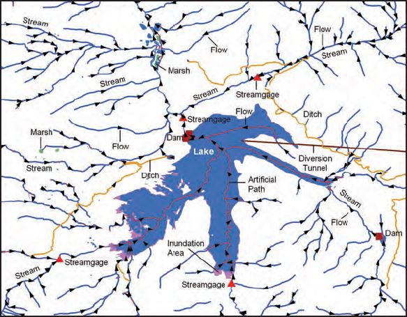
The USGS National Hydrography Dataset (NHD) service from The National Map (TNM) is a comprehensive set of digital spatial data that encodes information about naturally occurring and constructed bodies of surface water (lakes, ponds, and reservoirs), paths through which water flows (canals, ditches, streams, and rivers), and related entities such as point features (springs, wells, stream gages, and dams). The information encoded about these features includes classification and other characteristics, delineation, geographic name, position and related measures, a "reach code" through which other information can be related to the NHD, and the direction of water flow. The network of reach codes delineating water and...
These data were released prior to the October 1, 2016 effective date for the USGS’s policy dictating the review, approval, and release of scientific data as referenced in USGS Survey Manual Chapter 502.8 Fundamental Science Practices: Review and Approval of Scientific Data for Release. Perennial streams in Idaho have been modeled using regression equations for 7-day, 2-year low flows (7Q2) described in Wood and others (2009, U.S. Geological Survey Scientific Investigations Report 2009-5015). The model produces "synthetic" streams based on 10-meter resolution digitial elevation models that have been processed to agree closely with 1:24,000-scale National Hydrography Dataset flowlines. See Larger_Work_Citation report...
These data were released prior to the October 1, 2016 effective date for the USGS’s policy dictating the review, approval, and release of scientific data as referenced in USGS Survey Manual Chapter 502.8 Fundamental Science Practices: Review and Approval of Scientific Data for Release. The locations of approximately 23,000 current and historical U.S. Geological Survey (USGS) streamgages in the United States and Puerto Rico (with the exception of Alaska) have been snapped to the medium resolution National Hydrography Dataset (NHD). The NHD contains geospatial information about mapped surface-water features, such as streams, lakes, and reservoirs, etc., creating a hydrologic network that can be used to determine...
U.S. Geological Survey, Department of the Interior - The annual National Hydrography Dataset (NHD) stewardship plan is to maintain hydrography data in the NHD over the United States and its territories. NHD for the nation has been collected and is now in maintenance mode. Interested parties who wish to become a NHD stewardship partner with the USGS in FY15 or in future years should contact a USGS Geospatial Liaison - http://liaisons.usgs.gov/geospatial/documents/TNM_Partnership_User_ContactList.pdf. To find out more about hydrography stewardship go to http://nhd.usgs.gov/stewardship.html or for exact project status information on areas currently in work go to http://nhd.usgs.gov/project_status.html
The USGS National Hydrography Dataset (NHD) service from The National Map (TNM) is a comprehensive set of digital spatial data that encodes information about naturally occurring and constructed bodies of surface water (lakes, ponds, and reservoirs), paths through which water flows (canals, ditches, streams, and rivers), and related entities such as point features (springs, wells, stream gages, and dams). The information encoded about these features includes classification and other characteristics, delineation, geographic name, position and related measures, a "reach code" through which other information can be related to the NHD, and the direction of water flow. The network of reach codes delineating water and...
Categories: Data;
Types: ArcGIS REST Map Service,
Map Service;
Tags: HU,
Hydrography,
NGP-TNM,
NHD,
Overlay Map Service,
These data were released prior to the October 1, 2016 effective date for the USGS’s policy dictating the review, approval, and release of scientific data as referenced in USGS Survey Manual Chapter 502.8 Fundamental Science Practices: Review and Approval of Scientific Data for Release. This vector coverage of hydrography centerlines was derived from the National Hydrography Dataset (NHD), and encompasses all of Ohio and portions of Indiana, Michigan, Kentucky, West Virginia, Pennsylvania, and New York. This coverage is comprised of 105 Catalog Units (CUs) obtained from http://nhd.usgs.gov/. Each CU approximately represents a single 8-digit Hydrologic Unit Code (HUC).
The National Hydrography Dataset (NHD) is a comprehensive set of digital spatial data that encodes information about naturally occurring and constructed bodies of surface water (lakes, ponds, and reservoirs), paths through which water flows (canals, ditches, streams, and rivers), and related entities such as point features (springs, wells, stream gages, and dams). The information encoded about these features includes classification and other characteristics, delineation, geographic name, position and related measures, a "reach code" through which other information can be related to the NHD, and the direction of water flow. The network of reach codes delineating water and transported material flow allows users to...
Landforms along the Pacific, Gulf of Mexico, and Atlantic coastlines for the conterminous United States are attributed with the relative vulnerability of horizontal erosion due to sea-level rise to characterize coastal zone stability. The position and extent of landforms are geospatially indexed as line-events where these coastal zone features are intersected by the linear-referenced 2013 - 2014 U.S. Geological Survey National Hydrography Dataset Coastline, which corresponds to the National Oceanic and Atmospheric Administration (NOAA) 2013 - 2014 mean high water level datum delineated in intertidal zones open to oceans, behind barrier coasts in bays, lagoons, and estuaries, and sometimes where tidal currents reach...

USGS Hydro-NHD is a tile cache base map that combines hydrography data in The National Map from the National Hydrography Dataset (NHD) along with the Watershed Boundary Dataset (WBD). The NHD is a comprehensive set of digital spatial data that encodes information about naturally occurring and constructed bodies of surface water (lakes, ponds, and reservoirs), paths through which water flows (canals, ditches, streams, and rivers), and related entities such as point features (springs, wells, stream gages, and dams). The information encoded about these features includes classification and other characteristics, delineation, geographic name, position and related measures, a "reach code" through which other information...
Point Events are data that USGS has linked to the NHD. These include USGS stream gages, dams, hydrologic unit outlets, stream flow alterations, and water quality stations.
Categories: Data;
Types: ArcGIS REST Map Service,
ArcGIS Service Definition,
Citation,
Downloadable,
Map Service,
OGC WFS Layer,
OGC WMS Layer,
Shapefile;
Tags: Dams,
Dams,
Divergences,
Divergences,
Gaging station,
USGS Hydro-NHD is a tile cache base map that combines hydrography data in The National Map from the National Hydrography Dataset (NHD) along with the Watershed Boundary Dataset (WBD). The NHD is a comprehensive set of digital spatial data that encodes information about naturally occurring and constructed bodies of surface water (lakes, ponds, and reservoirs), paths through which water flows (canals, ditches, streams, and rivers), and related entities such as point features (springs, wells, stream gages, and dams). The information encoded about these features includes classification and other characteristics, delineation, geographic name, position and related measures, a "reach code" through which other information...
U.S. Geological Survey, Department of the Interior - The annual National Hydrography Dataset (NHD) stewardship plan is to maintain hydrography data in the NHD over the United States and its territories. NHD for the nation has been collected and is now in maintenance mode. Interested parties who wish to become a NHD stewardship partner with the USGS in FY17 or in future years should contact a USGS Geospatial Liaison - http://liaisons.usgs.gov/geospatial/documents/TNM_Partnership_User_ContactList.pdf. To find out more about hydrography stewardship go to http://nhd.usgs.gov/stewardship.html or for exact project status information on areas currently in work go to http://nhd.usgs.gov/project_status.html
Types: Citation;
Tags: Hydrography,
NGDA,
NHD,
National Geospatial Data Asset,
National Hydrography Dataset,
|

|
