Filters: Tags: NHD (X)
71 results (12ms)|
Filters
Date Range
Extensions Types
Contacts
Categories Tag Types Tag Schemes |
National Recreational Rivers Database
Categories: Data;
Types: ArcGIS REST Map Service,
ArcGIS Service Definition,
Downloadable,
Map Service;
Tags: Access Sites,
Access points,
Campgrounds,
Camping,
NHD,
The National Hydrography Dataset (NHD) is a feature-based database that interconnects and uniquely identifies the sream segments or reaches that comprise the nation's surface water drainage system. Medium resolution NHD is based on the content of the U.S. Geological Survey 1:100,000-scale Digital Line Graph (DLG) hydrography data, integrated with reach-related information from the U.S. Environmental Protection Agency Reach File Version 3.0 (RF3). More specifically, it contains reach codes for networked features and isolated lakes, flow direction, names, stream level, and centerline representations for areal water bodies. Reaches are also defined to represent water bodies and the approximate shorelines of the Great...
Categories: Data;
Types: Downloadable;
Tags: Artificial Path,
Canal / Ditch,
FWHydrography,
Gaging Station,
Hydrography,
The locations of approximately 23,000 current and historical U.S. Geological Survey (USGS) streamgages in the United States and Puerto Rico (with the exception of Alaska) have been snapped to the medium resolution National Hydrography Dataset (NHD). The NHD contains geospatial information about mapped surface-water features, such as streams, lakes, and reservoirs, etc., creating a hydrologic network that can be used to determine what is upstream or downstream from a point of interest on the NHD network. An automated snapping process made the initial determination of the NHD location of each streamgage. These initial NHD locations were comprehensively reviewed by local USGS personnel to ensure that streamgages were...
Categories: Data;
Types: Downloadable;
Tags: Base flow index,
Gaging Stations,
Hydrography,
NHD,
National Hydrography Dataset,
The NHDPlus Version 1.0 is an integrated suite of application-ready geospatial data sets that incorporate many of the best features of the National Hydrography Dataset (NHD) and the National Elevation Dataset (NED). The NHDPlus includes a stream network (based on the 1:100,000-scale NHD), improved networking, naming, and "value-added attributes" (VAA's). NHDPlus also includes elevation-derived catchments (drainage areas) produced using a drainage enforcement technique first broadly applied in New England, and thus dubbed "The New-England Method". This technique involves "burning-in" the 1:100,000-scale NHD and when available building "walls" using the national Watershed Boundary Dataset (WBD). The resulting modified...
The NHDPlus Version 1.0 is an integrated suite of application-ready geospatial data sets that incorporate many of the best features of the National Hydrography Dataset (NHD) and the National Elevation Dataset (NED). The NHDPlus includes a stream network (based on the 1:100,000-scale NHD), improved networking, naming, and "value-added attributes" (VAA's). NHDPlus also includes elevation-derived catchments (drainage areas) produced using a drainage enforcement technique first broadly applied in New England, and thus dubbed "The New-England Method". This technique involves "burning-in" the 1:100,000-scale NHD and when available building "walls" using the national Watershed Boundary Dataset (WBD). The resulting modified...
These data were released prior to the October 1, 2016 effective date for the USGS’s policy dictating the review, approval, and release of scientific data as referenced in USGS Survey Manual Chapter 502.8 Fundamental Science Practices: Review and Approval of Scientific Data for Release. The locations of approximately 23,000 current and historical U.S. Geological Survey (USGS) streamgages in the United States and Puerto Rico (with the exception of Alaska) have been snapped to the medium resolution National Hydrography Dataset (NHD). The NHD contains geospatial information about mapped surface-water features, such as streams, lakes, and reservoirs, etc., creating a hydrologic network that can be used to determine...
U.S. Geological Survey, Department of the Interior - The annual National Hydrography Dataset (NHD) stewardship plan is to maintain hydrography data in the NHD over the United States and its territories. NHD for the nation has been collected and is now in maintenance mode. Interested parties who wish to become a NHD stewardship partner with the USGS in FY15 or in future years should contact a USGS Geospatial Liaison - http://liaisons.usgs.gov/geospatial/documents/TNM_Partnership_User_ContactList.pdf. To find out more about hydrography stewardship go to http://nhd.usgs.gov/stewardship.html or for exact project status information on areas currently in work go to http://nhd.usgs.gov/project_status.html

The USGS National Hydrography Dataset (NHD) service from The National Map (TNM) is a comprehensive set of digital spatial data that encodes information about naturally occurring and constructed bodies of surface water (lakes, ponds, and reservoirs), paths through which water flows (canals, ditches, streams, and rivers), and related entities such as point features (springs, wells, stream gages, and dams). The information encoded about these features includes classification and other characteristics, delineation, geographic name, position and related measures, a "reach code" through which other information can be related to the NHD, and the direction of water flow. The network of reach codes delineating water and...
Categories: Data;
Types: ArcGIS REST Map Service,
Map Service;
Tags: HU,
Hydrography,
NGP-TNM,
NHD,
Overlay Map Service,

This is the flowline feature in the NHD plus dataset for region 18. For full attribute definition, consult the NHD plus user guide. TNC joined the attributes from the tbl_nhd_flowlineattributesflow table in the geodatabase to get all of the relevant attributes. The NHDPlus Version 1.0 is an integrated suite of application-ready geospatial data sets that incorporate many of the best features of the National Hydrography Dataset (NHD) and the National Elevation Dataset (NED). The NHDPlus includes a stream network (based on the 1:100,000-scale NHD), improved networking, naming, and "value-added attributes" (VAA's). NHDPlus also includes elevation-derived catchments (drainage areas) produced using a drainage enforcement...
The National Hydrography Dataset (NHD) is a comprehensive set of digital spatial data that contains information about surface water features such as lakes, ponds, streams, rivers, springs and wells. The NHD is based upon the content of USGS Digital Line Graph (DLG) hydrography data integrated with reach-related information from the EPA Reach File Version 3 (RF3).
The National Hydrography Dataset (NHD) is a feature-based database that interconnects and uniquely identifies the stream segments or reaches that make up the nation's surface water drainage system. NHD data was originally developed at 1:100,000-scale and exists at that scale for the whole country. This high-resolution NHD, generally developed at 1:24,000/1:12,000 scale, adds detail to the original 1:100,000-scale NHD. (Data for Alaska, Puerto Rico and the Virgin Islands was developed at high-resolution, not 1:100,000 scale.) Local resolution NHD is being developed where partners and data exist. The NHD contains reach codes for networked features, flow direction, names, and centerline representations for areal water...
Categories: Data;
Types: Downloadable;
Tags: Artificial Path,
Canal / Ditch,
FWHydrography,
Gaging Station,
Hydrography,
The National Hydrography Dataset (NHD) is a feature-based database that interconnects and uniquely identifies the sream segments or reaches that comprise the nation's surface water drainage system. Medium resolution NHD is based on the content of the U.S. Geological Survey 1:100,000-scale Digital Line Graph (DLG) hydrography data, integrated with reach-related information from the U.S. Environmental Protection Agency Reach File Version 3.0 (RF3). More specifically, it contains reach codes for networked features and isolated lakes, flow direction, names, stream level, and centerline representations for areal water bodies. Reaches are also defined to represent water bodies and the approximate shorelines of the Great...
Derived data layer based upon the NHD+ data layer. The layer represents the distance to the intermitant streams and is used to model invasive annual grasses and noxious forbs and species assembleages. The NHDPlus Version 1.0 is an integrated suite of application-ready geospatial data sets that incorporate many of the best features of the National Hydrography Dataset (NHD) and the National Elevation Dataset (NED). The NHDPlus includes a stream network (based on the 1:100,000-scale NHD), improved networking, naming, and "value-added attributes" (VAA's). NHDPlus also includes elevation-derived catchments (drainage areas) produced using a drainage enforcement technique first broadly applied in New England, and thus...
The NHDPlus Version 1.0 is an integrated suite of application-ready geospatial data sets that incorporate many of the best features of the National Hydrography Dataset (NHD) and the National Elevation Dataset (NED). The NHDPlus includes a stream network (based on the 1:100,000-scale NHD), improved networking, naming, and "value-added attributes" (VAA's). NHDPlus also includes elevation-derived catchments (drainage areas) produced using a drainage enforcement technique first broadly applied in New England, and thus dubbed "The New-England Method". This technique involves "burning-in" the 1:100,000-scale NHD and when available building "walls" using the national Watershed Boundary Dataset (WBD). The resulting modified...
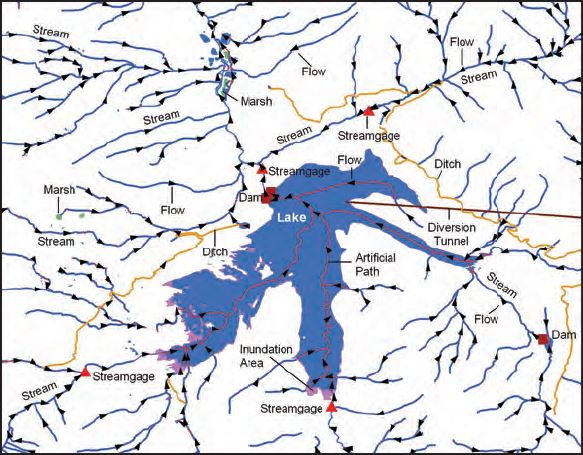
The National Hydrography Dataset (NHD) and Watershed Boundary Dataset (WBD) are used to portray surface water on The National Map. The NHD represents the drainage network with features such as rivers, streams, canals, lakes, ponds, coastline, dams, and streamgages. An important use of the NHD is the analysis of surface-water systems. This analysis is possible because many types of location information can be linked to the NHD, such as flow-volume, velocity, temperature, water chemistry, pollution control classifications, aquatic species habitat, recreation designations, or water rights. Such network-linked data is typically maintained by various organizations at Federal, State, and local levels, as well as research,...
These data were released prior to the October 1, 2016 effective date for the USGS’s policy dictating the review, approval, and release of scientific data as referenced in USGS Survey Manual Chapter 502.8 Fundamental Science Practices: Review and Approval of Scientific Data for Release. This vector coverage of hydrography centerlines was derived from the National Hydrography Dataset (NHD), and encompasses all of Ohio and portions of Indiana, Michigan, Kentucky, West Virginia, Pennsylvania, and New York. This coverage is comprised of 105 Catalog Units (CUs) obtained from http://nhd.usgs.gov/. Each CU approximately represents a single 8-digit Hydrologic Unit Code (HUC).
HEM events were created from fish screens, stream gages, and surface water diversions within the Lemhi SubBasin in Idaho. Data was gathered from the following sources: Idaho Fish and Game, Idaho Power, Idaho Water Engineering, and Idaho Water Resources Water Rights. The data assembled represented fish screens, water withdrawals from the stream, and flow gauging stations.
Categories: Data;
Types: ArcGIS REST Map Service,
ArcGIS Service Definition,
Citation,
Downloadable,
Map Service,
OGC WFS Layer,
OGC WMS Layer,
Shapefile;
Tags: HEM,
HEM,
NHD,
Point Event,
environment,
The National Hydrography Dataset (NHD) is a comprehensive set of digital spatial data that encodes information about naturally occurring and constructed bodies of surface water (lakes, ponds, and reservoirs), paths through which water flows (canals, ditches, streams, and rivers), and related entities such as point features (springs, wells, stream gages, and dams). The information encoded about these features includes classification and other characteristics, delineation, geographic name, position and related measures, a "reach code" through which other information can be related to the NHD, and the direction of water flow. The network of reach codes delineating water and transported material flow allows users to...
The NHDPlus Version 1.0 is an integrated suite of application-ready geospatial data sets that incorporate many of the best features of the National Hydrography Dataset (NHD) and the National Elevation Dataset (NED). The NHDPlus includes a stream network (based on the 1:100,000-scale NHD), improved networking, naming, and "value-added attributes" (VAA's). NHDPlus also includes elevation-derived catchments (drainage areas) produced using a drainage enforcement technique first broadly applied in New England, and thus dubbed "The New-England Method". This technique involves "burning-in" the 1:100,000-scale NHD and when available building "walls" using the national Watershed Boundary Dataset (WBD). The resulting modified...
The NHDPlus Version 1.0 is an integrated suite of application-ready geospatial data sets that incorporate many of the best features of the National Hydrography Dataset (NHD) and the National Elevation Dataset (NED). The NHDPlus includes a stream network (based on the 1:100,000-scale NHD), improved networking, naming, and "value-added attributes" (VAA's). NHDPlus also includes elevation-derived catchments (drainage areas) produced using a drainage enforcement technique first broadly applied in New England, and thus dubbed "The New-England Method". This technique involves "burning-in" the 1:100,000-scale NHD and when available building "walls" using the national Watershed Boundary Dataset (WBD). The resulting modified...
|

|
