Filters: Tags: National Geospatial Data Asset (X)
166 results (51ms)|
Filters
Date Range
Extensions Types
Contacts
Categories Tag Types Tag Schemes |
As part of the next generation NLCD 2016 mapping process, the NLCD research team developed a suite of intermediate products that were used to generate the final NLCD Land Cover products. Some of those products also have value as independent products and are provided here. Please read the product descriptions to understand what the product represents. Questions about the NLCD 2016 land cover product can be directed to the NLCD 2016 land cover mapping team at USGS EROS, Sioux Falls, SD (605) 594-6151 or mrlc@usgs.gov. See included spatial metadata for more details.
Types: Map Service,
OGC WFS Layer,
OGC WMS Layer,
OGC WMS Service;
Tags: GIS,
Image processing,
Land Use Land Cover Theme,
Land cover,
N.L.C.D.,
The U.S. Geological Survey (USGS), in partnership with several federal agencies, has now developed and released seven National Land Cover Database (NLCD) products: NLCD 1992, 2001, 2006, 2011, 2016, 2019, and 2021. Beginning with the 2016 release, land cover products were created for two-to-three-year intervals between 2001 and the most recent year. These products provide spatially explicit and reliable information on the Nation’s land cover and land cover change. NLCD continues to provide innovative, consistent, and robust methodologies for production of a multi-temporal land cover and land cover change database. The NLCD 2021 release is update based, so the Land Cover and Impervious Surface products released in...
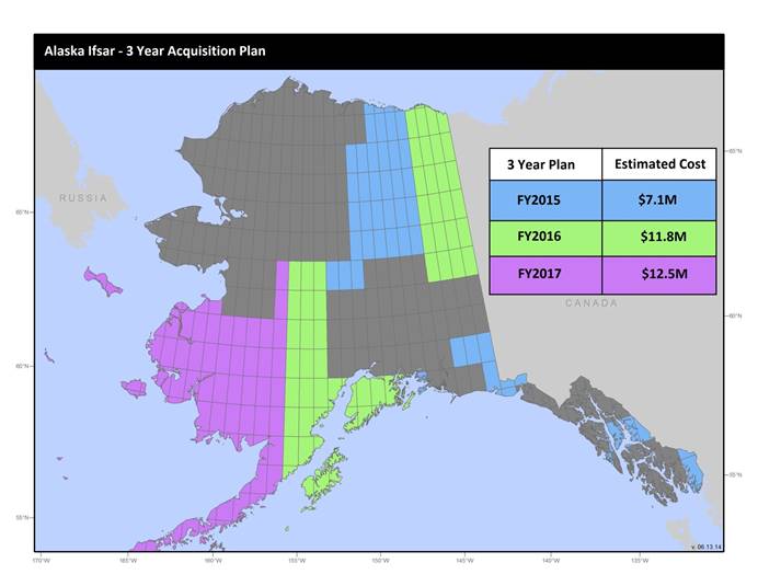
U.S. Geological Survey, Department of the Interior - The annual Alaska IfSAR and DEM acquisition plan is part of the 3DEP initiative to collect high-quality elevation data in the form of interferometric synthetic aperture radar (IfSAR) and light detection and ranging (lidar) data over Alaska. This acquisition plan addresses concerns raised in GAO Report 13-94 regarding geospatial coordination, and supports FGDC data coordination initiatives led by the Department of Interior's Geospatial Information Officer. Mapping a State the size and complexity of Alaska through a partnered effort such as the Alaska Mapping Initiative requires dedicated collaboration and coordination across multiple levels of government. State...
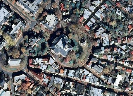
USGS_EROS_Ortho_SCALE service contains orthorectified digital aerial photographs and satellite imagery that are commonly referred to as orthoimagery. The imagery in this service is derived from high resolution images that combine the visual attributes of an aerial photograph with the spatial accuracy and geometric characteristics of a map. The resolution is primarily 1-meter, and the source imagery is acquired through partnerships with U.S. Department of Agriculture’s Farm Service Agency and other cooperating Federal, State, and local agencies. One meter resolution imagery means that each pixel in the orthoimage covers one meter on the earth’s surface. TNM_Large_Scale_Imagery service data is viewed at scales of...
The USGS Protected Areas Database of the United States (PAD-US) is the nation's inventory of protected areas, including public open space and voluntarily provided, private protected areas, identified as an A-16 National Geospatial Data Asset in the Cadastral Theme (http://www.fgdc.gov/ngda-reports/NGDA_Datasets.html). PAD-US is an ongoing project with several published versions of a spatial database of areas dedicated to the preservation of biological diversity, and other natural, recreational or cultural uses, managed for these purposes through legal or other effective means. The geodatabase maps and describes public open space and other protected areas. Most areas are public lands owned in fee; however, long-term...
Types: Citation;
Tags: Agricultural Research Service,
Alabama (AL),
Alaska (AK),
American Samoa (AS),
Arizona (AZ),
The U.S. Geological Survey (USGS), in partnership with several federal agencies, has developed and released four National Land Cover Database (NLCD) products over the past two decades: NLCD 1992, 2001, 2006, and 2011. These products provide spatially explicit and reliable information on the Nation’s land cover and land cover change. To continue the legacy of NLCD and further establish a long-term monitoring capability for the Nation’s land resources, the USGS has designed a new generation of NLCD products named NLCD 2016. The NLCD 2016 design aims to provide innovative, consistent, and robust methodologies for production of a multi-temporal land cover and land cover change database from 2001 to 2016 at 2–3-year...
Categories: Data Release - Revised;
Types: Map Service,
OGC WFS Layer,
OGC WMS Layer,
OGC WMS Service;
Tags: GIS,
Image processing,
Land Use Land Cover Theme,
Land cover,
NGDA,

The National Hydrography Dataset (NHD) is a feature-based database that interconnects and uniquely identifies the stream segments or reaches that make up the nation's surface water drainage system. NHD data was originally developed at 1:100,000-scale and exists at that scale for the whole country. This high-resolution NHD, generally developed at 1:24,000/1:12,000 scale, adds detail to the original 1:100,000-scale NHD. (Data for Alaska, Puerto Rico and the Virgin Islands was developed at high-resolution, not 1:100,000 scale.) Local resolution NHD is being developed where partners and data exist. The NHD contains reach codes for networked features, flow direction, names, and centerline representations for areal water...
Categories: Data;
Types: Citation;
Tags: Administrative watershed units,
Area of Complex Channels,
Area to be submerged,
Basin,
Bay/Inlet,
Disclaimer: this is an historic version of NLCD provided for research and citation purposes. Different release dates of NLCD cannot be used with other release dates for correct analysis. Each release of NLCD generates a complete set of directly comparable products. These products must be used together for correct analysis. You can find the latest suite of synced products at www.mrlc.gov. The National Land Cover Database (NLCD) 1992 Land Cover layer was produced through a cooperative project conducted by the Multi-Resolution Land Characteristics (MRLC) Consortium. The MRLC Consortium is a partnership of federal agencies (www.mrlc.gov), consisting of the U.S. Geological Survey (USGS), the National Oceanic and Atmospheric...
The National Land Cover Database 2001 Land Cover 2011 Edition layer is produced through a cooperative project conducted by the Multi-Resolution Land Characteristics (MRLC) Consortium. The MRLC Consortium is a partnership of federal agencies (www.mrlc.gov), consisting of the U.S. Geological Survey (USGS), the National Oceanic and Atmospheric Administration (NOAA), the U.S. Environmental Protection Agency (EPA), the U.S. Department of Agriculture - Forest Service (USDA-FS), the National Park Service (NPS), the U.S. Fish and Wildlife Service (FWS), the Bureau of Land Management (BLM) and the USDA Natural Resources Conservation Service (NRCS). One of the primary goals of the project is to generate a current, consistent,...
The 2020 North American Land Cover 30-meter dataset was produced as part of the North American Land Change Monitoring System (NALCMS), a trilateral effort between Natural Resources Canada, the United States Geological Survey, and three Mexican organizations including the National Institute of Statistics and Geography (Instituto Nacional de Estadística y Geografía), National Commission for the Knowledge and Use of the Biodiversity (Comisión Nacional Para el Conocimiento y Uso de la Biodiversidad), and the National Forestry Commission of Mexico (Comisión Nacional Forestal). The collaboration is facilitated by the Commission for Environmental Cooperation, an international organization created by the Canada, Mexico,...
U.S. Geological Survey, Department of the Interior - The annual lidar and DEM acquisition plan is part of the 3DEP initiative to systematically collect enhanced elevation data (Quality Level 2) in the form of high-quality light detection and ranging (lidar) data over the conterminous United States, Hawaii, and the territories on an 8-year schedule. The FY17 acquisition plan currently anticipates collecting 225,000 sq. mi. or more depending on partnerships and other contributions to the plan. Interested parties who wish to become a funding partner with the USGS in FY17 or in future years should contact a USGS Geospatial Liaison - http://liaisons.usgs.gov/geospatial/documents/TNM_Partnership_User_ContactList.pdf....
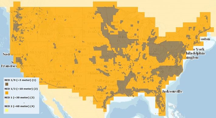
The USGS Elevation Availability service from The National Map (TNM) shows the best available resolution of downloadable elevation data, and is updated approximately every two weeks with National Elevation Dataset (NED) releases. NED 2- (in Alaska only), 1-, and 1/3-arc-second data are staged for download by 1x1 degree tiles in ArcGrid, GridFloat, or IMG formats in The National Map viewer, while NED 1/9 arc-second data is staged by 15x15 minute tiles in IMG format only. For additional information on the NED, go to http://ned.usgs.gov/.
Spatial analysis and statistical summaries of the Protected Areas Database of the United States (PAD-US) provide land managers and decision makers with a general assessment of management intent for biodiversity protection, natural resource management, and recreation access across the nation. The PAD-US 2.1 Combined Fee, Designation, Easement feature class (with Military Lands and Tribal Areas from the Proclamation and Other Planning Boundaries feature class) was modified to remove overlaps, avoiding overestimation in protected area statistics and to support user needs. A Python scripted process ("CreateVectorAnalysisFileScript.zip" associated item of PAD-US 2.1 Spatial Analysis and Statistics, 2021; https://doi.org/10.5066/P9KJLB3Q)...
Categories: Data;
Tags: Agricultural Research Service,
Alabama (AL),
Alaska (AK),
American Samoa (AS),
Arizona (AZ),
Protection Status spatial analysis and statistical summaries of the Protected Areas Database of the United States (PAD-US) provide land managers and decision makers with a general assessment of management intent to protect biodiversity across the nation and identify areas managed for multiple uses, including natural resource extraction, as represented by the GAP Status Code (see GAP Status Code Definition sheet in all associated Summary Statistics by GAP Status Code Microsoft Excel Workbook download). Area statistics include total acreage, acres by managing agency, and percent protection. These summaries are available for various units of interest to stakeholders: National, State, Department of the Interior Region,...
Categories: Data;
Tags: Agricultural Research Service,
Alabama (AL),
Alaska (AK),
American Samoa (AS),
Arizona (AZ),
Spatial analysis and statistical summaries of the Protected Areas Database of the United States (PAD-US) provide land managers and decision makers with a general assessment of management intent for biodiversity protection, natural resource management, and recreation access across the nation. This data release presents results from statistical summaries of the PAD-US 2.1 protection status for various land unit boundaries (Protected Areas Database of the United States (PAD-US) 2.1 Summary Statistics by GAP Status Code) as well as summaries of public access status (Protected Areas Database of the United States (PAD-US) 2.1 Summary Statistics by Public Access Category), provided in Microsoft Excel readable workbooks,...
The USGS Protected Areas Database of the United States (PAD-US) is the nation's inventory of protected areas, including public open space and voluntarily provided, private protected areas, identified as an A-16 National Geospatial Data Asset in the Cadastral Theme (http://www.fgdc.gov/ngda-reports/NGDA_Datasets.html). PAD-US is an ongoing project with several published versions of a spatial database of areas dedicated to the preservation of biological diversity, and other natural, recreational or cultural uses, managed for these purposes through legal or other effective means. The geodatabase maps and describes public open space and other protected areas. Most areas are public lands owned in fee; however, long-term...
Types: Citation;
Tags: Agricultural Research Service,
Alabama (AL),
Alaska (AK),
American Samoa (AS),
Arizona (AZ),
|

|
