Filters
Date Types (for Date Range)
Contacts
Categories
Tag Types
Tag Schemes
|

Cell maps for each oil and gas assessment unit were created by the USGS as a method for illustrating the degree of exploration, type of production, and distribution of production in an assessment unit or province. Each cell represents a quarter-mile square of the land surface, and the cells are coded to represent whether the wells included within the cell are predominantly oil-producing, gas-producing, both oil and gas-producing, dry, or the type of production of the wells located within the cell is unknown. The well information was initially retrieved from the IHS Energy Group, PI/Dwights PLUS Well Data on CD-ROM, which is a proprietary, commercial database containing information for most oil and gas wells in the...
Categories: Data,
pre-SM502.8;
Tags: 506701 = Conasauga-Rome/Conasauga,
50670101 = Rome Trough,
506702 = Sevier-Knox Trenton,
50670201 = Lower Paleozoic Carbonates,
506703 = Utica-Lower Paleozoic, All tags...
50670301 = Lower Paleozoic Carbonates in Thrust Belt,
50670302 = Knox Unconformity,
50670303 = Black River-Trenton Hydrothermal Dolomite,
50670304 = Lockport Dolomite,
50670361 = Clinton-Medina Basin Center,
50670362 = Clinton-Medina Transitional Northeast,
50670363 = Clinton-Medina Transitional,
50670364 = Tuscarora Basin Center,
506704 = Devonian Shale-Middle and Upper Paleozoic,
50670401 = Oriskany Sandstone-Structural,
50670402 = Oriskany Sandstone-Stratigraphic,
50670403 = Greenbrier Limestone,
50670404 = Mississippian Sandstones,
50670461 = Greater Big Sandy,
50670462 = Northwestern Ohio Shale,
50670463 = Devonian Siltstone and Shale,
50670464 = Marcellus Shale,
50670465 = Catskill Sandstones and Siltstone,
50670466 = Berea Sandstone,
506705 = Carboniferous Coal-Bed Gas,
50670581 = Pocahontas Basin,
50670582 = East Dunkard (Folded),
50670583 = West Dunkard (Unfolded),
50670584 = Central Appalachian Shelf,
50670585 = Appalachain Anthracite and Semi-Anthracite,
506706 = Pottsville Coal-Bed Gas,
50670681 = Cahaba Basin,
67 = Appalachian Basin,
AL,
Appalachian Basin,
Assessment Unit,
Cells,
Coalbed methane resources,
Earth Science,
Economic geology,
Energy Resources,
GA,
Gas hydrate resources,
Geology,
KY,
MD,
Milici, Robert C.,
NC,
NJ,
NY,
National Assessment of Oil and Gas,
Natural Gas,
Natural Resources,
Natural gas resources,
OH,
Oil,
Oil sand resources,
Oil shale resources,
PA,
Resource Assessment,
TN,
U.S. Geological Survey,
US01 = Alabama,
US13 = Georgia,
US21 = Kentucky,
US24 = Maryland,
US34 = New Jersey,
US36 = New York,
US37 = North Carolina,
US39 = Ohio,
US42 = Pennsylvania,
US47 = Tennessee,
US51 = Virginia,
US54 = West Virginia,
USGS,
USGS Science Data Catalog (SDC),
USGS World Energy Region 5,
USGS World Energy Region 5,
United States,
VA,
WV,
geoscientificInformation, Fewer tags

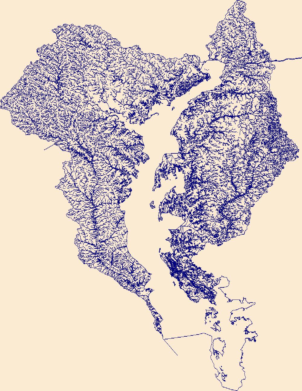
The High Resolution National Hydrography Dataset Plus (NHDPlus HR) is an integrated set of geospatial data layers, including the National Hydrography Dataset (NHD), National Watershed Boundary Dataset (WBD), and 3D Elevation Program Digital Elevation Model (3DEP DEM). The NHDPlus HR combines the NHD, 3DEP DEMs, and WBD to a data suite that includes the NHD stream network with linear referencing functionality, the WBD hydrologic units, elevation-derived catchment areas for each stream segment, "value added attributes" (VAAs), and other features that enhance hydrologic data analysis and routing.
Tags: 4-digit hydrologic unit,
Accomack County,
Adams County,
Albemarle County,
Alexandria County, All tags...
Allegany County,
Arlington County,
Augusta County,
Bedford County,
Berkeley County,
Carroll County,
Charles County,
Clarke County,
Cumberland County,
DC,
District of Columbia,
District of Columbia County,
Downloadable Data,
Fairfax County,
Falls Church County,
Fauquier County,
FileGDB,
Franklin County,
Frederick County,
Fulton County,
Garrett County,
Grant County,
Greene County,
HU-4 Subregion,
HU4,
HU4_0207,
Hampshire County,
Hardy County,
Harrisonburg County,
Highland County,
Huntingdon County,
Hydrography,
Jefferson County,
King George County,
Loudoun County,
MD,
Madison County,
Manassas County,
Manassas Park County,
Maryland,
Mineral County,
Montgomery County,
Morgan County,
NHDPlus HR Rasters,
NHDPlus High Resolution (NHDPlus HR),
National Hydrography Dataset (NHD),
National Hydrography Dataset Plus High Resolution (NHDPlus HR),
National Hydrography Dataset Plus High Resolution (NHDPlus HR) Current,
Nelson County,
Northumberland County,
PA,
Page County,
Pendleton County,
Pennsylvania,
Perry County,
Pocahontas County,
Preston County,
Prince George's County,
Prince William County,
Randolph County,
Rappahannock County,
Richmond County,
Rockingham County,
Shenandoah County,
Somerset County,
St. Mary's County,
Stafford County,
Staunton County,
Tucker County,
US,
United States,
VA,
Virginia,
WV,
Warren County,
Washington County,
Waynesboro County,
West Virginia,
Westmoreland County,
Winchester County,
base maps,
cartography,
catchments,
channels,
digital elevation models,
drainage basins,
earthsciences,
environment,
geographic information systems,
geoscientificInformation,
geospatial analysis,
hydrographic datasets,
hydrographic features,
hydrology,
inlandWaters,
lakes,
land surface characteristics,
reservoirs,
river reaches,
rivers,
streamflow,
streamflow data,
streams,
surface water quality,
topography,
water resources,
waterbodies,
watersheds, Fewer tags

This model archive provides all data, code, and modeling results used in Barclay and others (2023) to assess the ability of process-guided deep learning stream temperature models to accurately incorporate groundwater-discharge processes. We assessed the performance of an existing process-guided deep learning stream temperature model of the Delaware River Basin (USA) and explored four approaches for improving groundwater process representation: 1) a custom loss function that leverages the unique patterns of air and water temperature coupling resulting from different temperature drivers, 2) inclusion of additional groundwater-relevant catchment attributes, 3) incorporation of additional process model outputs, and...
Categories: Data;
Tags: DE,
Delaware,
Hydrology,
MD,
Maryland, All tags...
NJ,
NY,
New Jersey,
New York,
PA,
Pennsylvania,
US,
USGS Science Data Catalog (SDC),
United States,
Water Quality,
Water Resources,
deep learning,
environment,
explainable AI (XAI),
groundwater,
hybrid modeling,
inlandWaters,
machine learning,
modeling,
process guided deep learning,
stream temperature,
temperature,
water,
water resources, Fewer tags

The High Resolution National Hydrography Dataset Plus (NHDPlus HR) is an integrated set of geospatial data layers, including the National Hydrography Dataset (NHD), National Watershed Boundary Dataset (WBD), and 3D Elevation Program Digital Elevation Model (3DEP DEM). The NHDPlus HR combines the NHD, 3DEP DEMs, and WBD to a data suite that includes the NHD stream network with linear referencing functionality, the WBD hydrologic units, elevation-derived catchment areas for each stream segment, "value added attributes" (VAAs), and other features that enhance hydrologic data analysis and routing.
Tags: 4-digit hydrologic unit,
Accomack County,
Atlantic County,
Berks County,
Broome County, All tags...
Bucks County,
Burlington County,
Camden County,
Cape May County,
Carbon County,
Cecil County,
Chenango County,
Chester County,
Cumberland County,
DE,
Delaware,
Delaware County,
Downloadable Data,
FileGDB,
Gloucester County,
Greene County,
HU-4 Subregion,
HU4,
HU4_0204,
Hunterdon County,
Hydrography,
Kent County,
Lackawanna County,
Lancaster County,
Lebanon County,
Lehigh County,
Luzerne County,
MD,
Maryland,
Mercer County,
Monmouth County,
Monroe County,
Montgomery County,
Morris County,
NHDPlus HR Rasters,
NHDPlus High Resolution (NHDPlus HR),
NJ,
NY,
National Hydrography Dataset (NHD),
National Hydrography Dataset Plus High Resolution (NHDPlus HR),
National Hydrography Dataset Plus High Resolution (NHDPlus HR) Current,
New Castle County,
New Jersey,
New York,
Northampton County,
Ocean County,
Orange County,
PA,
Pennsylvania,
Philadelphia County,
Pike County,
Queens County,
Salem County,
Schoharie County,
Schuylkill County,
Sullivan County,
Sussex County,
US,
Ulster County,
United States,
VA,
Virginia,
Virginia Beach County,
Warren County,
Wayne County,
Worcester County,
base maps,
cartography,
catchments,
channels,
digital elevation models,
drainage basins,
earthsciences,
environment,
geographic information systems,
geoscientificInformation,
geospatial analysis,
hydrographic datasets,
hydrographic features,
hydrology,
inlandWaters,
lakes,
land surface characteristics,
reservoirs,
river reaches,
rivers,
streamflow,
streamflow data,
streams,
surface water quality,
topography,
water resources,
waterbodies,
watersheds, Fewer tags

The High Resolution National Hydrography Dataset Plus (NHDPlus HR) is an integrated set of geospatial data layers, including the National Hydrography Dataset (NHD), National Watershed Boundary Dataset (WBD), and 3D Elevation Program Digital Elevation Model (3DEP DEM). The NHDPlus HR combines the NHD, 3DEP DEMs, and WBD to a data suite that includes the NHD stream network with linear referencing functionality, the WBD hydrologic units, elevation-derived catchment areas for each stream segment, "value added attributes" (VAAs), and other features that enhance hydrologic data analysis and routing.
Tags: 4-digit hydrologic unit,
Adams County,
Allegany County,
Baltimore County,
Bedford County, All tags...
Berks County,
Blair County,
Bradford County,
Broome County,
Cambria County,
Cameron County,
Carbon County,
Carroll County,
Cecil County,
Centre County,
Chemung County,
Chenango County,
Chester County,
Clearfield County,
Clinton County,
Columbia County,
Cortland County,
Cumberland County,
Dauphin County,
Delaware County,
Downloadable Data,
Elk County,
FileGDB,
Franklin County,
Fulton County,
HU-4 Subregion,
HU4,
HU4_0205,
Harford County,
Herkimer County,
Huntingdon County,
Hydrography,
Indiana County,
Jefferson County,
Juniata County,
Lackawanna County,
Lancaster County,
Lebanon County,
Livingston County,
Luzerne County,
Lycoming County,
MD,
Madison County,
Maryland,
McKean County,
Mifflin County,
Montgomery County,
Montour County,
NHDPlus HR Rasters,
NHDPlus High Resolution (NHDPlus HR),
NY,
National Hydrography Dataset (NHD),
National Hydrography Dataset Plus High Resolution (NHDPlus HR),
National Hydrography Dataset Plus High Resolution (NHDPlus HR) Current,
New York,
Northumberland County,
Oneida County,
Onondaga County,
Ontario County,
Otsego County,
PA,
Pennsylvania,
Perry County,
Potter County,
Schoharie County,
Schuyler County,
Schuylkill County,
Snyder County,
Somerset County,
Steuben County,
Sullivan County,
Susquehanna County,
Tioga County,
Tompkins County,
US,
Union County,
United States,
Wayne County,
Wyoming County,
Yates County,
York County,
base maps,
cartography,
catchments,
channels,
digital elevation models,
drainage basins,
earthsciences,
environment,
geographic information systems,
geoscientificInformation,
geospatial analysis,
hydrographic datasets,
hydrographic features,
hydrology,
inlandWaters,
lakes,
land surface characteristics,
reservoirs,
river reaches,
rivers,
streamflow,
streamflow data,
streams,
surface water quality,
topography,
water resources,
waterbodies,
watersheds, Fewer tags
The High Resolution National Hydrography Dataset Plus (NHDPlus HR) is an integrated set of geospatial data layers, including the National Hydrography Dataset (NHD), National Watershed Boundary Dataset (WBD), and 3D Elevation Program Digital Elevation Model (3DEP DEM). The NHDPlus HR combines the NHD, 3DEP DEMs, and WBD to a data suite that includes the NHD stream network with linear referencing functionality, the WBD hydrologic units, elevation-derived catchment areas for each stream segment, "value added attributes" (VAAs), and other features that enhance hydrologic data analysis and routing.
Tags: 4-digit hydrologic unit,
Anne Arundel County,
Baltimore County,
Calvert County,
Caroline County, All tags...
Carroll County,
Cecil County,
Charles County,
Chester County,
DE,
Delaware,
Dorchester County,
Downloadable Data,
FileGDB,
Frederick County,
HU-4 Subregion,
HU4,
HU4_0206,
Harford County,
Howard County,
Hydrography,
Kent County,
MD,
Maryland,
Montgomery County,
NHDPlus HR Rasters,
NHDPlus High Resolution (NHDPlus HR),
National Hydrography Dataset (NHD),
National Hydrography Dataset Plus High Resolution (NHDPlus HR),
National Hydrography Dataset Plus High Resolution (NHDPlus HR) Current,
New Castle County,
PA,
Pennsylvania,
Prince George's County,
Queen Anne's County,
Somerset County,
St. Mary's County,
Talbot County,
US,
United States,
York County,
base maps,
cartography,
catchments,
channels,
digital elevation models,
drainage basins,
earthsciences,
environment,
geographic information systems,
geoscientificInformation,
geospatial analysis,
hydrographic datasets,
hydrographic features,
hydrology,
inlandWaters,
lakes,
land surface characteristics,
reservoirs,
river reaches,
rivers,
streamflow,
streamflow data,
streams,
surface water quality,
topography,
water resources,
waterbodies,
watersheds, Fewer tags
|
|

