Filters
Date Range
Extensions
Types
Contacts
Categories
Tag Types
Tag Schemes
|

The digitally compiled map includes geology, oil and gas field centerpoints, and geologic provinces of the Arctic (North Pole area encircled by 640 N Latitude). The GIS data sets were designed originally in ESRI's ARC/INFO ver. 8.0.1 and were published as part of a series of interim CD-ROM products of the U.S. Geological Survey's World Energy Project (WEP). The goal of the WEP is to assess the undiscovered, technically recoverable oil and gas resources of the world. Results of this assessment were reported in the year 2000 (see USGS DDS-60; http://pubs.usgs.gov/dds/dds-060/).
Categories: Data,
pre-SM502.8;
Types: Downloadable,
Map Service,
OGC WFS Layer,
OGC WMS Layer,
Shapefile;
Tags: Admiralty Arch, Province 1061,
Anabar Basin, Province 1200,
Anabar-Olenek High, Province 1202,
Anadyr Basin, Province 1300,
Anzhu Uplift, Province 1255, All tags...
ArcInfo,
ArcView,
Arctic,
Arctic Coastal Shelf, Province 5241,
Arctic Ocean Slope, Province 1117,
Ayon Basin, Province 1253,
Baffin Basin, Province 5207,
Baltic Shield-Norwegian Caledonides, Province 4016,
Banks Basin, Province 5233,
Barents Continental Slope, Province 4013,
Beaufort Shelf OCS, Province 5081,
Blagoveshchensk Basin, Province 1254,
Boothia Basin, Province 5230,
Canada Basin-Beaufort Slope OCS, Province 5079,
Canadian Cordillera, Province 5248,
Canadian Shield, Province 5226,
Central Alaska, Province 5002,
Central Barents Platform, Province 4012,
Central Kara High, Province 1070,
Chukchi Borderland OCS, Province 5078,
Chukchi Shelf OCS, Province 5080,
Cornwallis Foldbelt, Province 5237,
De Long High, Province 1257,
Earth Science,
Earth Science,
East Greenland Foldbelt, Province 5201,
East Greenland Rift Basins, Province 5200,
Economic geology,
Ellesmere Foldbelt, Province 5238,
Foxe Basin, Province 5229,
Geology,
Greenland Shield, Province 5202,
Grumant Uplift, Province 1064,
Hammerfest-Varanger Basin, Province 4015,
Hope Basin OCS, Province 5082,
Hudson Bay Basin, Province 5228,
Kane Basin, Province 5206,
Kempendiay Region, Province 1212,
Khatanga Saddle, Province 1201,
Kola Monocline-Finnmark Platform, Province 1051,
Koryak-Kamchatka Foldbelt, Province 1304,
Labrador-Newfoundland Shelf, Province 5215,
Laptev Shelf, Province 1218,
Lena-Vilyuy Basin, Province 1214,
Ludlov Saddle, Province 1059,
Mackenzie Delta Slope, Province 5240,
Mackenzie Delta, Province 5239,
Mackenzie Foldbelt, Province 5246,
Mezen Basin, Province 1006,
Minto Arch, Province 5235,
Moma Basin, Province 1252,
Natural Gas,
Natural Resources,
Natural gas resources,
Nepa-Botuoba Arch, Province 1210,
North Barents Basin, Province 1060,
North Chukchi Basin, Province 1258,
North Greenland Foldbelt, Province 5204,
North Greenland Platform, Province 5203,
North Novaya Zemlya Basin, Province 1065,
Northern Alaska, Province 5001,
Northern Interior Basins, Province 5242,
Norton Basin OCS, Province 5086,
Novaya Zemlya Monocline, Province 1062,
Novosibirsk Basin, Province 1256,
Oil,
Oil sand resources,
Oil shale resources,
Parry Island Foldbelt, Province 5236,
Penzhina Basin, Province 1303,
Petroleum,
Resource Assessment,
Schmidt Basin, Province 1071,
Severnaya Zemlya High, Province 1072,
South Arctic Basin, Province 5231,
South Barents Basin, Province 1050,
South Chukchi-Hope Basin, Province 1261,
Southeast Greenland Basin, Province 5209,
St. Anna Basin, Province 1066,
Svalbard High, Province 4011,
Sverdrup Basin, Province 5234,
Taimyr-Kara High, Province 1176,
Timan High, Province 1007,
Timan-Pechora Basin, Province 1008,
Troms-Bjornoya, Province 4014,
Tunguska Basin, Province 1203,
Turukhan-Igarka Uplift, Province 1205,
Turukhan-Norilsk Folded Zone, Province 1204,
U.S. Geological Survey,
U.S. Geological Survey,
USGS,
USGS Science Data Catalog (SDC),
Uedineniya Basin, Province 1069,
Ural-Novaya Zemlya Foldbelt, Province 1017,
Ushakov High, Province 1068,
Verkhoyan-Chukotka Folded Region, Province 1250,
Vestford-Helgeland, Province 4017,
Vize High, Province 1067,
Wandel Sea Basin, Province 5205,
West Greenland Basin, Province 5208,
West Siberian Basin, Province 1174,
Wollaston Basin, Province 5232,
Wrangel Basin, Province 1259,
Wrangel-Herald Uplift, Province 1260,
Yenisey-Khatanga Basin, Province 1175,
Yukon Basin, Province 5247,
Zyryanka Basin, Province 1251,
arctic,
bathymetry,
digital geologic map,
environment,
gas,
geologic age,
geologic map,
geology,
geoscientificInformation,
oil,
oilgas,
wep,
worldgeologicmaps, Fewer tags

The Apparent Wilcox Group thickness maps are contoured from location and top information derived from the Petroleum Information (PI) Wells database. The Wilcox apparent thickness map was constructed by searching for Wilcox and Midway Group tops. Apparent thickness is computed by subtracting Midway top from the Wilcox top. Geographic control is superimposed on the maps from USGS state line, county, elevation and other data files. The veracity of the PI Wells database is being checked by comparison to published cross sections and geologic maps. Interpretation of the depth to Wilcox and apparent thickness maps along with published measured sections and cross sections indicates that portions of Texas, Louisiana, Mississippi...
Categories: Data,
pre-SM502.8;
Types: Downloadable,
Map Service,
OGC WFS Layer,
OGC WMS Layer,
Shapefile;
Tags: 47 = Western Gulf,
48 = East Texas Basin,
49 = Louisiana-Mississippi Salt Basins,
50 = Florida Peninsula,
AL, All tags...
AR,
Coal,
Coalbed Methane,
Coalbed methane resources,
Earth Science,
Economic geology,
Energy Resources,
Eocene,
FL,
Geology,
Gulf Coast,
Gulf Coast,
Gulf Coast Framework Studies,
Gulf of Mexico,
Isopach,
LA,
MS,
Natural Gas,
Natural Resources,
Natural gas resources,
Oil,
Paleocene,
Petroleum,
Resource Assessment,
TX,
Tertiary Systems,
U.S. Geological Survey,
US01 = Alabama,
US05 = Arkansas,
US12 = Florida,
US22 = Louisiana,
US28 = Mississippi,
US48 = Texas,
USGS,
USGS Science Data Catalog (SDC),
United States,
Wilcox,
economy,
environment,
geoscientificInformation,
gulfcoastframework,
gulfroom,
oilgas, Fewer tags

The digitally compiled map includes geology, oil and gas field centerpoints, and geologic provinces of the Arctic (North Pole area encircled by 640 N Latitude). The GIS data sets were designed originally in ESRI's ARC/INFO ver. 8.0.1 and were published as part of a series of interim CD-ROM products of the U.S. Geological Survey's World Energy Project (WEP). The goal of the WEP is to assess the undiscovered, technically recoverable oil and gas resources of the world. Results of this assessment were reported in the year 2000 (see USGS DDS-60; http://pubs.usgs.gov/dds/dds-060/).
Categories: Data,
pre-SM502.8;
Types: Downloadable,
Map Service,
OGC WFS Layer,
OGC WMS Layer,
Shapefile;
Tags: Admiralty Arch, Province 1061,
Anabar Basin, Province 1200,
Anabar-Olenek High, Province 1202,
Anadyr Basin, Province 1300,
Anzhu Uplift, Province 1255, All tags...
ArcInfo,
ArcView,
Arctic,
Arctic Coastal Shelf, Province 5241,
Arctic Ocean Slope, Province 1117,
Ayon Basin, Province 1253,
Baffin Basin, Province 5207,
Baltic Shield-Norwegian Caledonides, Province 4016,
Banks Basin, Province 5233,
Barents Continental Slope, Province 4013,
Beaufort Shelf OCS, Province 5081,
Blagoveshchensk Basin, Province 1254,
Boothia Basin, Province 5230,
Canada Basin-Beaufort Slope OCS, Province 5079,
Canadian Cordillera, Province 5248,
Canadian Shield, Province 5226,
Central Alaska, Province 5002,
Central Barents Platform, Province 4012,
Central Kara High, Province 1070,
Chukchi Borderland OCS, Province 5078,
Chukchi Shelf OCS, Province 5080,
Cornwallis Foldbelt, Province 5237,
De Long High, Province 1257,
Earth Science,
Earth Science,
East Greenland Foldbelt, Province 5201,
East Greenland Rift Basins, Province 5200,
Economic geology,
Ellesmere Foldbelt, Province 5238,
Foxe Basin, Province 5229,
Geology,
Greenland Shield, Province 5202,
Grumant Uplift, Province 1064,
Hammerfest-Varanger Basin, Province 4015,
Hope Basin OCS, Province 5082,
Hudson Bay Basin, Province 5228,
Kane Basin, Province 5206,
Kempendiay Region, Province 1212,
Khatanga Saddle, Province 1201,
Kola Monocline-Finnmark Platform, Province 1051,
Koryak-Kamchatka Foldbelt, Province 1304,
Labrador-Newfoundland Shelf, Province 5215,
Laptev Shelf, Province 1218,
Lena-Vilyuy Basin, Province 1214,
Ludlov Saddle, Province 1059,
Mackenzie Delta Slope, Province 5240,
Mackenzie Delta, Province 5239,
Mackenzie Foldbelt, Province 5246,
Mezen Basin, Province 1006,
Minto Arch, Province 5235,
Moma Basin, Province 1252,
Natural Gas,
Natural Resources,
Natural gas resources,
Nepa-Botuoba Arch, Province 1210,
North Barents Basin, Province 1060,
North Chukchi Basin, Province 1258,
North Greenland Foldbelt, Province 5204,
North Greenland Platform, Province 5203,
North Novaya Zemlya Basin, Province 1065,
Northern Alaska, Province 5001,
Northern Interior Basins, Province 5242,
Norton Basin OCS, Province 5086,
Novaya Zemlya Monocline, Province 1062,
Novosibirsk Basin, Province 1256,
Oil,
Oil sand resources,
Oil shale resources,
Parry Island Foldbelt, Province 5236,
Penzhina Basin, Province 1303,
Petroleum,
Resource Assessment,
Schmidt Basin, Province 1071,
Severnaya Zemlya High, Province 1072,
South Arctic Basin, Province 5231,
South Barents Basin, Province 1050,
South Chukchi-Hope Basin, Province 1261,
Southeast Greenland Basin, Province 5209,
St. Anna Basin, Province 1066,
Svalbard High, Province 4011,
Sverdrup Basin, Province 5234,
Taimyr-Kara High, Province 1176,
Timan High, Province 1007,
Timan-Pechora Basin, Province 1008,
Troms-Bjornoya, Province 4014,
Tunguska Basin, Province 1203,
Turukhan-Igarka Uplift, Province 1205,
Turukhan-Norilsk Folded Zone, Province 1204,
U.S. Geological Survey,
U.S. Geological Survey,
USGS,
USGS Science Data Catalog (SDC),
Uedineniya Basin, Province 1069,
Ural-Novaya Zemlya Foldbelt, Province 1017,
Ushakov High, Province 1068,
Verkhoyan-Chukotka Folded Region, Province 1250,
Vestford-Helgeland, Province 4017,
Vize High, Province 1067,
Wandel Sea Basin, Province 5205,
West Greenland Basin, Province 5208,
West Siberian Basin, Province 1174,
Wollaston Basin, Province 5232,
Wrangel Basin, Province 1259,
Wrangel-Herald Uplift, Province 1260,
Yenisey-Khatanga Basin, Province 1175,
Yukon Basin, Province 5247,
Zyryanka Basin, Province 1251,
arctic,
bathymetry,
digital geologic map,
environment,
gas,
geologic age,
geologic map,
geology,
geoscientificInformation,
oil,
oilgas,
wep,
worldgeologicmaps, Fewer tags

This coverage includes arcs and arc labels that hold the Bouguer Gravity anomaly value for contours and type contours of the original map of Bangladesh with the same name.
Categories: Data;
Types: Downloadable,
Map Service,
OGC WFS Layer,
OGC WMS Layer,
Shapefile;
Tags: Anomaly,
Bangladesh,
Digital map,
Earth Science,
Ganges-Brahmaputra Delta, Province 8047, All tags...
Gas,
Geology,
Geophysics,
Gravimetric survey,
Gravity,
Jalangi-Sylhet/Burdwan Composite, Total Petroleum System 804702,
Jenam/Bhuban-Bokabil, Total Petroleum System 804703,
Natural Gas,
Oil,
Oil,
Permian Coal, Total Petroleum System 804701,
Petroleum,
Resource Assessment,
South Asia,
South Asia, Region 8,
Tertiary Composite Total Petroleum System,
U.S. Geological Survey,
USGS,
USGS Science Data Catalog (SDC),
bangladesh,
geoscientificInformation,
oilgas,
wep,
worldgeologicmaps, Fewer tags

The National Geologic Map Database (NGMDB) is a Congressionally mandated national archive of geoscience maps, reports, and stratigraphic information. The Geologic Mapping Act of 1992 and its Reauthorizations calls for the U.S. Geological Survey and the Association of American State Geologists (AASG) to cooperatively build this national archive, according to technical and scientific standards whose development is coordinated by the NGMDB. The NGMDB consists of a comprehensive set of publication citations, stratigraphic nomenclature, downloadable content in raster and vector formats, unpublished source information, and guidance on standards development. The NGMDB contains information on more than 110,000 maps and...
Tags: AASG,
Aeromagnetics,
Association of American State Geologists,
Bedrock geology,
CSS, All tags...
Coal,
Coastal and marine geology,
Core Science Systems,
Earthquakes,
Environmental hazards,
Environmental resources,
GIS,
Geochemistry,
Geochronology,
Geologic map,
Geology,
Geophysics,
Geothermal resources,
Gravity,
Hazards,
Landslides,
Metallic resources,
NCGMP,
NGDA,
NGDA Geology Theme,
NGDAID52,
NGMDB,
National Cooperative Geologic Mapping Program,
National Geologic Map Database,
National Geospatial Data Asset,
Non-metallic resources,
North America,
Oil and gas,
Paleontology,
Petroleum,
Radioactivity,
Resources,
Stratigraphic nomenclature,
Stratigraphy,
Surficial geology,
U.S.,
U.S. Geological Survey,
US,
USGS,
USGS Science Data Catalog (SDC),
USGS:366411b4-98bc-41f7-876b-778f91aff6b6,
United States,
Volcanoes,
WMS,
Water resources,
Web-mapping,
geoscientificInformation,
image service,
mapview, Fewer tags

The U.S. Geological Survey (USGS) has compiled a geodatabase containing mineral-related geospatial data for 19 countries of interest in the Indo-Pacific region (area of study): Bangladesh, Bhutan, Brunei, Burma, Fiji, Malaysia, Mongolia, Nauru, New Caledonia, New Zealand, Papua New Guinea, Philippines, Singapore, Solomon Islands, South Korea (Republic of Korea), Sri Lanka, Taiwan, Timor-Leste, and Vietnam. The data can be used in analyses of the extractive fuel and nonfuel mineral industries integral for the successful operation of the mineral industries within the area of study. This geodatabase reflects the USGS ongoing commitment to its mission of understanding the nature and distribution of global mineral commodity...
Types: Map Service,
OGC WFS Layer,
OGC WMS Layer,
OGC WMS Service;
Tags: Asia,
Bangladesh,
Bhutan,
Brunei,
Burma, All tags...
Economic Geology,
Energy Resources,
Fiji,
Geography,
Indo-Pacific,
Information Sciences,
LNG,
Malaysia,
Malaysia-Thailand Joint Development Area (JDA),
Mineral Resources,
Mongolia,
NGL,
Nauru,
New Caledonia,
New Zealand,
Papua New Guinea,
Philippines,
Singapore,
Solomon Islands,
South Korea (Republic of Korea),
Sri Lanka,
Taiwan,
Timor-Leste,
USGS Science Data Catalog (SDC),
Vietnam,
alumina,
aluminum,
antimony,
arsenic,
bauxite,
bismuth,
cadmium,
calcium carbonate,
cement,
chromium,
clay,
coal,
coal area,
coal occurrence,
coal resources,
coalbed methane,
coalfield,
cobalt,
coke,
commodity,
continuous resources,
conventional resources,
copper,
copper occurrence,
copper resources,
development,
exploration,
feldspar,
ferroalloys,
fluorspar,
gallium,
garnet,
gas,
gas production,
gemstone,
gold,
graphite,
gypsum,
hydrocarbon resources,
hydrogen,
indium,
iron and steel,
iron ore,
iron sand,
lead,
lime,
liquefied natural gas,
liquid natural gas,
lithium,
magnesium,
manganese,
mica,
mine,
mineral,
mineral commodity,
mineral development,
mineral exploration,
mineral occurrence,
mineral processing,
mineral resources,
minerals,
mining,
mining exploration,
molybdenum,
natural gas,
natural gas liquids,
nickel,
niobium,
nitrogen,
oil,
oil and gas,
oil production,
palladium,
peat,
perlite,
permissive,
petroleum,
phosphate,
phosphate rock,
platinum,
platinum group elements,
porphyry copper,
potassium,
pyrophyllite,
rare earths,
recoverable resources,
refinery,
refining,
resources,
rhenium,
rhodium,
salt,
sand and gravel,
scandium,
sediment-hosted stratabound copper,
selenium,
shale gas,
shale oil,
silica,
silica sand,
silicon,
silver,
smelting,
stone,
sulfur,
talc,
tantalum,
tellurium,
tight gas,
tight oil,
tin,
titanium,
tracts,
tungsten,
unconventional resources,
undiscovered resources,
uranium,
vanadium,
zeolites,
zinc,
zirconium, Fewer tags

This coverage includes arcs, polygons, and polygon labels that describe the generalized geologic age of surface outcrops of bedrock of Svalbard. It also includes shorelines.
Categories: Data,
pre-SM502.8;
Types: Downloadable,
Map Service,
OGC WFS Layer,
OGC WMS Layer,
Shapefile;
Tags: Adana/Sivas, Province 2079,
Adriatic Basin, Province 4058,
Aegean, Province 4075,
Age,
Alentejo-Guadalquivir Basin, Province 4077, All tags...
Alps, Province 4051,
Andalucia, Province 4088,
Anglo-Dutch Basin, Province 4036,
Anglo-Paris Basin, Province 4040,
Apulia Platform, Province 4059,
Aquitaine Basin, Province 4045,
Araks, Province 2080,
Armoricia, Province 4041,
Baltic Depression, Province 4021,
Baltic Shield-Norwegian Caledonides, Province 4016,
Barents Continental Slope, Province 4013,
Belorussian-Voronezh High, Province 1004,
Betic Zone, Province 4078,
Black Sea Continental Slope, Province 1107,
Bohemia, Province 4046,
Bresse Depression, Province 4054,
Carpathian-Balkanian Basin, Province 4061,
Corsican-Sardinian Basins, Province 4067,
Crete, Province 4076,
Dinaric Alps, Province 4071,
Dobrogea Foreland, Province 1103,
Dobrogean Orogen, Province 4063,
Earth Science,
Economic geology,
Euphrates/Mardin, Province 2075,
Europe,
Faeroes-Shetland-Orkney Basin, Province 4019,
Fennoscandian Border-Danish-Polish Margin, Province 4022,
Galician Basin, Province 4073,
Gas,
Generalized geology,
Geologic age,
Geologic map,
Geology,
Geology,
German-Polish Basin, Province 4033,
Haleb, Province 2076,
Hammerfest-Varanger Basin, Province 4015,
Hatton-Rockall Basin, Province 4020,
Horda-Norwegian-Danish Basin, Province 4023,
Iberian Massif, Province 4072,
Iberic Cordillera, Province 4083,
Ireland-Scotland Platform, Province 4026,
Irish Sea, Province 4030,
Jura, Province 4052,
Kardiff/Menders Massif, Province 2084,
Kola Monocline-Finnmark Platform, Province 1051,
Lesser Caucasus, Province 2081,
Lion-Camargue, Province 4056,
London-Brabant Platform, Province 4037,
Lusitanian Basin, Province 4074,
Massif Central, Province 4043,
Mediterranean Basin, Province 2070,
Mid-North Sea High, Province 4028,
Midland Valley-Forth Approaches Basin, Province 4027,
Molasse Basin, Province 4049,
Munsterland Basin, Province 4038,
NO,
Natural Gas,
Natural Resources,
Natural gas resources,
North Carpathian Basin, Province 4047,
North Sea Graben, Province 4025,
Northwest German Basin, Province 4035,
Norway,
Oil,
Oil,
Oil sand resources,
Oil shale resources,
Pannonian Basin, Province 4048,
Pelagian Basin, Province 2048,
Petroleum,
Po Basin, Province 4060,
Provence Basin, Province 4068,
Pyrenean Foothills-Ebro Basin, Province 4044,
Resource Assessment,
Rhine Graben, Province 4055,
Rif Basin, Province 2072,
Russian Craton Margin, Province 1011,
SV,
Sicily, Province 4066,
Southwest German Basin, Province 4039,
Spanish Trough-Cantabrian Zone, Province 4070,
Spitzbergen,
Svalbard,
Tajo-Duero Basin, Province 4082,
Thrace/Samsun, Province 2085,
Trans-Graben, Province 4053,
Transylvanian Basin, Province 4057,
Troms-Bjornoya, Province 4014,
Tuscany-Latium-Paola, Province 4062,
Tuz/Corum, Province 2083,
Tyrrhenian Basin, Province 4069,
U.S. Geological Survey,
USGS,
USGS Science Data Catalog (SDC),
Ukrainian Shield, Province 1013,
Vestford-Helgeland, Province 4017,
West Black Sea Basin, Province 4064,
Zagros Fold Belt, Province 2030,
Zagros Thrust Zone, Province 2031,
environment,
europe,
geoscientificInformation,
oilgas,
wep,
worldgeologicmaps, Fewer tags
Layers of geospatial data include roads, airports, trails, and railroads.
Tags: Airport Complex,
Airport Point,
Airport Runway,
Airports,
Airstrips, All tags...
Beaverhead,
Big Horn,
Blaine,
Broadwater,
Carbon,
Carter,
Cascade,
Chouteau,
Custer,
Daniels,
Dawson,
Deer Lodge,
Downloadable Data,
Esri File GeoDatabase 10,
Fallon,
Fergus,
FileGDB,
Flathead,
Gallatin,
Garfield,
Geographic names,
Glacier,
Golden Valley,
Granite,
Hill,
Jefferson,
Judith Basin,
Lake,
Lewis and Clark,
Liberty,
Lincoln,
MT,
Madison,
McCone,
Meagher,
Mineral,
Missoula,
Montana,
Musselshell,
National Transportation Dataset (NTD),
National Transportation Dataset (NTD),
Park,
Petroleum,
Phillips,
Pondera,
Powder River,
Powell,
Prairie,
Railways,
Ravalli,
Richland,
Roads,
Roosevelt,
Rosebud,
Sanders,
Sheridan,
Silver Bow,
State,
State,
Stillwater,
Sweet Grass,
Teton,
Toole,
Trail,
Trails,
Transportation,
Transportation,
Treasure,
US,
United States,
Valley,
Waterway,
Wheatland,
Wibaux,
Yellowstone,
transportation, Fewer tags
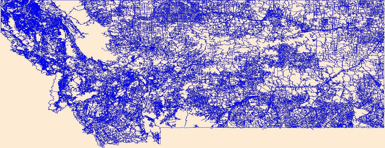
The National Hydrography Dataset (NHD) is a feature-based database that interconnects and uniquely identifies the stream segments or reaches that make up the nation's surface water drainage system. NHD data was originally developed at 1:100,000-scale and exists at that scale for the whole country. This high-resolution NHD, generally developed at 1:24,000/1:12,000 scale, adds detail to the original 1:100,000-scale NHD. (Data for Alaska, Puerto Rico and the Virgin Islands was developed at high-resolution, not 1:100,000 scale.) Local resolution NHD is being developed where partners and data exist. The NHD contains reach codes for networked features, flow direction, names, and centerline representations for areal water...
Tags: Administrative watershed units,
Administrative watershed units,
Area of Complex Channels,
Area to be submerged,
Basin, All tags...
Basin,
Bay/Inlet,
Boundaries,
Boundary,
Bridge,
Canal/Ditch,
Coastline,
Connector,
Dam/Weir,
Downloadable Data,
Drainage areas for surface water,
Drainageway,
Estuary,
Fergus,
Flow direction network,
Flume,
ForeShore,
Gaging Station,
Garfield,
Gate,
GeoPackage,
Golden Valley,
HU-8,
HU-8 Subbasin,
HU10,
HU12,
HU14,
HU16,
HU2,
HU4,
HU6,
HU8,
HU8_10040202,
HUC,
Hazard Zone,
Hydrographic,
Hydrography,
Hydrography,
Hydrography,
Hydrologic Unit Code,
Hydrologic Units,
Ice mass,
Inundation Area,
Levee,
Line,
Lock Chamber,
MT,
Marsh,
Montana,
Musselshell,
National Hydrography Dataset (NHD),
National Hydrography Dataset (NHD) Best Resolution,
National Hydrography Dataset (NHD) Best Resolution,
Nonearthen Shore,
Open Geospatial Consortium GeoPackage 1.2,
Orthoimage,
Petroleum,
Playa,
Point,
PointEvent,
Pond,
Rapids,
Rapids,
Reach,
Reach code,
Reef,
Region,
Reservoir,
Rock,
Rosebud,
Sea/Ocean,
Sink/Rise,
Sounding Datum Line,
Special Use Zone,
Special Use Zone Limit,
Spillway,
Stream,
Stream/River,
Sub-basin,
Sub-region,
Subbasin,
Submerged Stream,
Subregion,
Subwatershed,
Surface water systems,
Swamp,
Topographic,
Tunnel,
US,
Underground Conduit,
United States,
WBD,
WBD,
Wall,
Wash,
Water Intake Outflow,
Waterfall,
Watershed,
Watershed Boundaries,
Watershed Boundary Dataset,
Watershed Boundary Dataset,
Well,
Yellowstone,
artificial path,
boundaries,
dams,
drainage systems and characteristics,
inlandWaters,
lakes,
ngda,
rivers, Fewer tags
The Geographic Names Information System (GNIS) is the Federal standard for geographic nomenclature. The U.S. Geological Survey developed the GNIS for the U.S. Board on Geographic Names, a Federal inter-agency body chartered by public law to maintain uniform feature name usage throughout the Government and to promulgate standard names to the public. The GNIS is the official repository of domestic geographic names data; the official vehicle for geographic names use by all departments of the Federal Government; and the source for applying geographic names to Federal electronic and printed products of all types.
Tags: Antarctica,
Antarctica,
BGN,
Beaverhead,
Big Horn, All tags...
Blaine,
Board on Geographic Names,
Borough,
Broadwater,
Carbon,
Carter,
Cascade,
Census Area,
Chouteau,
Commonwealth,
County,
Custer,
Daniels,
Dawson,
Deer Lodge,
District,
Downloadable Data,
Fallon,
Feature class,
Feature coordinates,
Feature county,
Feature description,
Feature designation,
Feature history,
Feature indentification,
Feature name,
Feature state,
Fergus,
Flathead,
GNIS,
Gallatin,
Garfield,
Geographic Names,
Geographic Names Domestic Names,
Geographic Names Information System,
Geographic feature,
Geographic name,
Geographical feature,
Geographical name,
Glacier,
Golden Valley,
Granite,
Hill,
Jefferson,
Judith Basin,
Lake,
Lewis and Clark,
Liberty,
Lincoln,
MT,
Madison,
McCone,
Meagher,
Mineral,
Missoula,
Montana,
Municipio,
Musselshell,
National Geographic Names Information System (GNIS),
National Geographic Names Information System (GNIS),
Official feature name,
Outlying Area,
Parish,
Park,
Petroleum,
Phillips,
Place name,
Pondera,
Populated Place,
Powder River,
Powell,
Prairie,
Ravalli,
Richland,
Roosevelt,
Rosebud,
Sanders,
Sheridan,
Silver Bow,
State,
Stillwater,
Sweet Grass,
TXT (pipes),
Territories,
Territory,
Teton,
Toole,
Topographic Map,
Treasure,
U.S. Board on Geographic Names,
U.S. Geological Survey,
US,
USA,
USBGN,
USGS,
UTF-8 Pipe Delimited Text File nan,
United States,
United States,
United States,
Valley,
Variant name,
Wheatland,
Wibaux,
Yellowstone,
antarctic,
database,
economy,
environment,
feature,
gazetteer,
geographic,
geographic names,
geographical,
geography,
geospatial,
imageryBaseMapsEarthCover,
inlandWaters,
location,
map,
name,
place,
placename,
society,
structure,
topographic map,
toponymy, Fewer tags
This data set contains imagery from the National Agriculture Imagery Program (NAIP). The NAIP program is administered by USDA FSA and has been established to support two main FSA strategic goals centered on agricultural production. These are, increase stewardship of America's natural resources while enhancing the environment, and to ensure commodities are procured and distributed effectively and efficiently to increase food security. The NAIP program supports these goals by acquiring and providing ortho imagery that has been collected during the agricultural growing season in the U.S. The NAIP ortho imagery is tailored to meet FSA requirements and is a fundamental tool used to support FSA farm and conservation programs....
Types: Citation;
Tags: 3.75 x 3.75 minute,
30069,
4610805,
Aerial Compliance,
Compliance, All tags...
Digital Ortho rectified Image,
Downloadable Data,
JPEG2000,
MT,
MT069,
NAIP,
Ortho Rectification,
Orthoimagery,
PETROLEUM CO MT FSA,
Petroleum,
Quarter Quadrangle,
USDA National Agriculture Imagery Program (NAIP),
YELLOW WATER RESERVOIR,
YELLOW WATER RESERVOIR, NE,
farming, Fewer tags
This data set contains imagery from the National Agriculture Imagery Program (NAIP). The NAIP program is administered by USDA FSA and has been established to support two main FSA strategic goals centered on agricultural production. These are, increase stewardship of America's natural resources while enhancing the environment, and to ensure commodities are procured and distributed effectively and efficiently to increase food security. The NAIP program supports these goals by acquiring and providing ortho imagery that has been collected during the agricultural growing season in the U.S. The NAIP ortho imagery is tailored to meet FSA requirements and is a fundamental tool used to support FSA farm and conservation programs....
Types: Citation;
Tags: 3.75 x 3.75 minute,
30069,
4610805,
Aerial Compliance,
Compliance, All tags...
Digital Ortho rectified Image,
Downloadable Data,
JPEG2000,
MT,
MT069,
NAIP,
Ortho Rectification,
Orthoimagery,
PETROLEUM CO MT FSA,
Petroleum,
Quarter Quadrangle,
USDA National Agriculture Imagery Program (NAIP),
YELLOW WATER RESERVOIR,
YELLOW WATER RESERVOIR, SE,
farming, Fewer tags
This data set contains imagery from the National Agriculture Imagery Program (NAIP). The NAIP program is administered by USDA FSA and has been established to support two main FSA strategic goals centered on agricultural production. These are, increase stewardship of America's natural resources while enhancing the environment, and to ensure commodities are procured and distributed effectively and efficiently to increase food security. The NAIP program supports these goals by acquiring and providing ortho imagery that has been collected during the agricultural growing season in the U.S. The NAIP ortho imagery is tailored to meet FSA requirements and is a fundamental tool used to support FSA farm and conservation programs....
Types: Citation;
Tags: 3.75 x 3.75 minute,
30069,
4610805,
Aerial Compliance,
Compliance, All tags...
Digital Ortho rectified Image,
Downloadable Data,
JPEG2000,
MT,
MT069,
NAIP,
Ortho Rectification,
Orthoimagery,
PETROLEUM CO MT FSA,
Petroleum,
Quarter Quadrangle,
USDA National Agriculture Imagery Program (NAIP),
YELLOW WATER RESERVOIR,
YELLOW WATER RESERVOIR, SW,
farming, Fewer tags
This data set contains imagery from the National Agriculture Imagery Program (NAIP). The NAIP program is administered by USDA FSA and has been established to support two main FSA strategic goals centered on agricultural production. These are, increase stewardship of America's natural resources while enhancing the environment, and to ensure commodities are procured and distributed effectively and efficiently to increase food security. The NAIP program supports these goals by acquiring and providing ortho imagery that has been collected during the agricultural growing season in the U.S. The NAIP ortho imagery is tailored to meet FSA requirements and is a fundamental tool used to support FSA farm and conservation programs....
Types: Citation;
Tags: 3.75 x 3.75 minute,
30069,
4610808,
Aerial Compliance,
BREED SPRING, All tags...
BREED SPRING, NW,
Compliance,
Digital Ortho rectified Image,
Downloadable Data,
JPEG2000,
MT,
MT069,
NAIP,
Ortho Rectification,
Orthoimagery,
PETROLEUM CO MT FSA,
Petroleum,
Quarter Quadrangle,
USDA National Agriculture Imagery Program (NAIP),
farming, Fewer tags
This data set contains imagery from the National Agriculture Imagery Program (NAIP). The NAIP program is administered by USDA FSA and has been established to support two main FSA strategic goals centered on agricultural production. These are, increase stewardship of America's natural resources while enhancing the environment, and to ensure commodities are procured and distributed effectively and efficiently to increase food security. The NAIP program supports these goals by acquiring and providing ortho imagery that has been collected during the agricultural growing season in the U.S. The NAIP ortho imagery is tailored to meet FSA requirements and is a fundamental tool used to support FSA farm and conservation programs....
Types: Citation;
Tags: 3.75 x 3.75 minute,
30069,
4610811,
Aerial Compliance,
Compliance, All tags...
Digital Ortho rectified Image,
Downloadable Data,
JPEG2000,
MT,
MT069,
NAIP,
Ortho Rectification,
Orthoimagery,
PETROLEUM CO MT FSA,
PIKE CREEK HILLS WEST,
PIKE CREEK HILLS WEST, NE,
Petroleum,
Quarter Quadrangle,
USDA National Agriculture Imagery Program (NAIP),
farming, Fewer tags
This data set contains imagery from the National Agriculture Imagery Program (NAIP). The NAIP program is administered by USDA FSA and has been established to support two main FSA strategic goals centered on agricultural production. These are, increase stewardship of America's natural resources while enhancing the environment, and to ensure commodities are procured and distributed effectively and efficiently to increase food security. The NAIP program supports these goals by acquiring and providing ortho imagery that has been collected during the agricultural growing season in the U.S. The NAIP ortho imagery is tailored to meet FSA requirements and is a fundamental tool used to support FSA farm and conservation programs....
Types: Citation;
Tags: 3.75 x 3.75 minute,
30069,
4610813,
Aerial Compliance,
Compliance, All tags...
Digital Ortho rectified Image,
Downloadable Data,
FLATWILLOW,
FLATWILLOW, NW,
JPEG2000,
MT,
MT069,
NAIP,
Ortho Rectification,
Orthoimagery,
PETROLEUM CO MT FSA,
Petroleum,
Quarter Quadrangle,
USDA National Agriculture Imagery Program (NAIP),
farming, Fewer tags
This data set contains imagery from the National Agriculture Imagery Program (NAIP). The NAIP program is administered by USDA FSA and has been established to support two main FSA strategic goals centered on agricultural production. These are, increase stewardship of America's natural resources while enhancing the environment, and to ensure commodities are procured and distributed effectively and efficiently to increase food security. The NAIP program supports these goals by acquiring and providing ortho imagery that has been collected during the agricultural growing season in the U.S. The NAIP ortho imagery is tailored to meet FSA requirements and is a fundamental tool used to support FSA farm and conservation programs....
Types: Citation;
Tags: 3.75 x 3.75 minute,
30069,
4610814,
Aerial Compliance,
CROWLEY DAM, All tags...
CROWLEY DAM, NW,
Compliance,
Digital Ortho rectified Image,
Downloadable Data,
JPEG2000,
MT,
MT069,
NAIP,
Ortho Rectification,
Orthoimagery,
PETROLEUM CO MT FSA,
Petroleum,
Quarter Quadrangle,
USDA National Agriculture Imagery Program (NAIP),
farming, Fewer tags
This data set contains imagery from the National Agriculture Imagery Program (NAIP). The NAIP program is administered by USDA FSA and has been established to support two main FSA strategic goals centered on agricultural production. These are, increase stewardship of America's natural resources while enhancing the environment, and to ensure commodities are procured and distributed effectively and efficiently to increase food security. The NAIP program supports these goals by acquiring and providing ortho imagery that has been collected during the agricultural growing season in the U.S. The NAIP ortho imagery is tailored to meet FSA requirements and is a fundamental tool used to support FSA farm and conservation programs....
Types: Citation;
Tags: 3.75 x 3.75 minute,
30069,
4610701,
Aerial Compliance,
Compliance, All tags...
Digital Ortho rectified Image,
Downloadable Data,
JPEG2000,
MOSBY,
MOSBY, NW,
MT,
MT069,
NAIP,
Ortho Rectification,
Orthoimagery,
PETROLEUM CO MT FSA,
Petroleum,
Quarter Quadrangle,
USDA National Agriculture Imagery Program (NAIP),
farming, Fewer tags
This data set contains imagery from the National Agriculture Imagery Program (NAIP). The NAIP program is administered by USDA FSA and has been established to support two main FSA strategic goals centered on agricultural production. These are, increase stewardship of America's natural resources while enhancing the environment, and to ensure commodities are procured and distributed effectively and efficiently to increase food security. The NAIP program supports these goals by acquiring and providing ortho imagery that has been collected during the agricultural growing season in the U.S. The NAIP ortho imagery is tailored to meet FSA requirements and is a fundamental tool used to support FSA farm and conservation programs....
Types: Citation;
Tags: 3.75 x 3.75 minute,
30069,
4710843,
Aerial Compliance,
BEAR CREEK RESERVOIR, All tags...
BEAR CREEK RESERVOIR, SE,
Compliance,
Digital Ortho rectified Image,
Downloadable Data,
JPEG2000,
MT,
MT069,
NAIP,
Ortho Rectification,
Orthoimagery,
PETROLEUM CO MT FSA,
Petroleum,
Quarter Quadrangle,
USDA National Agriculture Imagery Program (NAIP),
farming, Fewer tags
This data set contains imagery from the National Agriculture Imagery Program (NAIP). The NAIP program is administered by USDA FSA and has been established to support two main FSA strategic goals centered on agricultural production. These are, increase stewardship of America's natural resources while enhancing the environment, and to ensure commodities are procured and distributed effectively and efficiently to increase food security. The NAIP program supports these goals by acquiring and providing ortho imagery that has been collected during the agricultural growing season in the U.S. The NAIP ortho imagery is tailored to meet FSA requirements and is a fundamental tool used to support FSA farm and conservation programs....
Types: Citation;
Tags: 3.75 x 3.75 minute,
30069,
4710847,
Aerial Compliance,
Compliance, All tags...
DAVIS SPRING,
DAVIS SPRING, SW,
Digital Ortho rectified Image,
Downloadable Data,
JPEG2000,
MT,
MT069,
NAIP,
Ortho Rectification,
Orthoimagery,
PETROLEUM CO MT FSA,
Petroleum,
Quarter Quadrangle,
USDA National Agriculture Imagery Program (NAIP),
farming, Fewer tags
|
|

